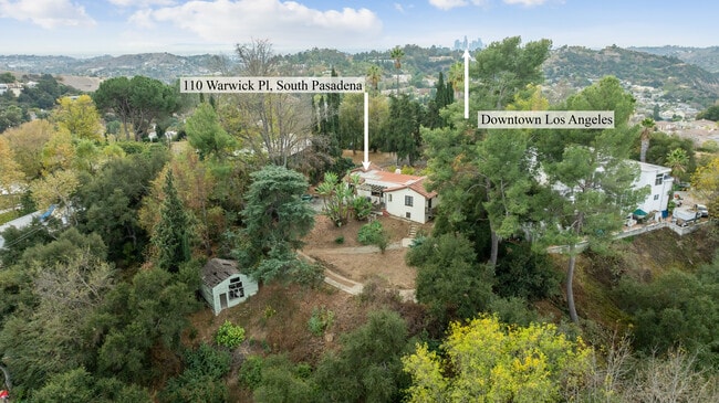
Property Record
0000, South Pasadena, CA 00000


Save to a Folder
{{folder.Name}}
{{folder.ListingIds.length}} Properties
{{folder.ListingIds.length}} Property
Create a New Folder
Property Detail
0000
Los Angeles-Long Beach-Glendale, CA
OAK RIDGE TRACT LOT COM AT MOST W COR OF LOT 226 TH N 73 5645 E 69.74 FT TH N 17 0555 W 21.82 FT TH N 0 55 E 193.50 FT TH N 65 26 W 106 FT TH S 11 36 E 157.9 FT TH S 68 08 W 44.75 FT TH S BEG PART OF VAC ST AND PART OF LOT 237
5311-006-013
LOS ANGELES
Residentialacreage
California
SPR110000*
226
B and X Area of moderate flood hazard, usually the area between the limits of the 100-year and 500-year floods.
0.15 AC
2025
Pasadena
2025
Los Angeles
480702
NEARBY LISTINGS FOR SALE OR LEASE
DEMOGRAPHICS near 0000
1 mile
3 mile
5 mile
2025 Total Population
26,026
242,638
674,039
2030 Population
25,753
239,921
666,296
Pop Growth 2025-2030
(1.05%)
(1.12%)
(1.15%)
Average Age
41
41
41
2025 Total Households
9,932
88,364
238,413
HH Growth 2025-2030
(1.24%)
(1.32%)
(1.31%)
Median Household Inc
$111,318
$102,257
$89,018
Avg Household Size
2.50
2.60
2.70
2025 Avg HH Vehicles
2.00
2.00
2.00
Median Home Value
$1,014,929
$1,012,418
$966,315
Median Year Built
1963
1955
1958
Nearby Places
Map Layers
Map Styles
 Street
 Aerial
Layers
 Traffic
 Biking
Places
Listings with unknown addresses are not visible on the map
- Restaurants
- Banks
- Shops
- Fitness
- Groceries
PUBLIC TRANSPORTATION
COMMUTER RAIL
L. A. Union Station Metrolink Station (91 Line - Southern California Regional Rail Authority (Metrolink), Antelope Valley Line - Southern California Regional Rail Authority (Metrolink), Orange County Line - Southern California Regional Rail Authority (Metrolink), Riverside Line - Southern California Regional Rail Authority (Metrolink), San Bernardino Line - Southern California Regional Rail Authority (Metrolink), Ventura County Line - Southern California Regional Rail Authority (Metrolink))
Drive
Walk
Distance
L. A. Union Station Metrolink Station (91 Line - Southern California Regional Rail Authority (Metrolink), Antelope Valley Line - Southern California Regional Rail Authority (Metrolink), Orange County Line - Southern California Regional Rail Authority (Metrolink), Riverside Line - Southern California Regional Rail Authority (Metrolink), San Bernardino Line - Southern California Regional Rail Authority (Metrolink), Ventura County Line - Southern California Regional Rail Authority (Metrolink))
12 min
6.5 mi
AIRPORT
Bob Hope
Drive
Walk
Distance
Bob Hope
26 min
17.3 mi
Los Angeles International
Drive
Walk
Distance
Los Angeles International
35 min
21.4 mi
Long Beach (Daugherty Field)
Drive
Walk
Distance
Long Beach (Daugherty Field)
40 min
25.1 mi
Freight Ports
Port of Long Beach
Drive
Walk
Distance
Port of Long Beach
41 min
27.9 mi
SALE & LEASE HISTORY
LISTING DATE
SALE/LEASE

Feb 10, 2025
For Sale
Nearby Properties
Address
Land Use
TOTAL SIZE
Lot Size
Zoning
Address
Land Use
TOTAL SIZE
Lot Size
Zoning
874,871 SF
25.01 AC
PSC*
Address
Land Use
TOTAL SIZE
Lot Size
Zoning
534,225 SF
Address
Land Use
TOTAL SIZE
Lot Size
Zoning
460,590 SF
23.95 AC
ALMPD*
Address
Land Use
TOTAL SIZE
Lot Size
Zoning
11,590 SF
14.43 AC
PSC*
Address
Land Use
TOTAL SIZE
Lot Size
Zoning
251,317 SF
114.56 AC
LAR1
Address
Land Use
TOTAL SIZE
Lot Size
Zoning
372,451 SF
3.24 AC
PSC*
Address
Land Use
TOTAL SIZE
Lot Size
Zoning
91,145 SF
1.21 AC
PSC-
Address
Land Use
TOTAL SIZE
Lot Size
Zoning
119,455 SF
5.04 AC
LACM
Address
Land Use
TOTAL SIZE
Lot Size
Zoning
130,553 SF
1.93 AC
PSR
Address
Land Use
TOTAL SIZE
Lot Size
Zoning
241,167 SF
1.57 AC
PSCD
Address
Land Use
TOTAL SIZE
Lot Size
Zoning
75,577 SF
1.92 AC
PSC-
Address
Land Use
TOTAL SIZE
Lot Size
Zoning
187,132 SF
1.64 AC
PSC-
Address
Land Use
TOTAL SIZE
Lot Size
Zoning
65,757 SF
0.91 AC
PSC-
Address
Land Use
TOTAL SIZE
Lot Size
Zoning
25,161 SF
0.58 AC
PSC-
Address
Land Use
TOTAL SIZE
Lot Size
Zoning
264,405 SF
1.92 AC
PSCD
Address
Land Use
TOTAL SIZE
Lot Size
Zoning
122,517 SF
1.90 AC
PSC-
Address
Land Use
TOTAL SIZE
Lot Size
Zoning
63,406 SF
5 AC
LAC4
Address
Land Use
TOTAL SIZE
Lot Size
Zoning
88,304 SF
0.96 AC
PSC*
Address
Land Use
TOTAL SIZE
Lot Size
Zoning
58,559 SF
0.60 AC
PSC-
Address
Land Use
TOTAL SIZE
Lot Size
Zoning
87,236 SF
2.62 AC
SPP*
Address
Land Use
TOTAL SIZE
Lot Size
Zoning
165,246 SF
1.10 AC
PSR*
Address
Land Use
TOTAL SIZE
Lot Size
Zoning
131,209 SF
1.51 AC
PSC-
Address
Land Use
TOTAL SIZE
Lot Size
Zoning
146,264 SF
1.87 AC
LAMR1
Address
Land Use
TOTAL SIZE
Lot Size
Zoning
155,339 SF
3.99 AC
LAMR1
Address
Land Use
TOTAL SIZE
Lot Size
Zoning
92,530 SF
3.16 AC
LARD1.5
Address
Land Use
TOTAL SIZE
Lot Size
Zoning
180,384 SF
2.03 AC
PSC*
Address
Land Use
TOTAL SIZE
Lot Size
Zoning
52,904 SF
0.69 AC
PSCD1*
Address
Land Use
TOTAL SIZE
Lot Size
Zoning
523,298 SF
5.74 AC
PSC-
Address
Land Use
TOTAL SIZE
Lot Size
Zoning
95,766 SF
0.70 AC
PSM*
Address
Land Use
TOTAL SIZE
Lot Size
Zoning
82,188 SF
1.20 AC
ALCBD/DRD*
The World's #1 Commercial Real Estate Marketplace
Connect with us
© 2026 CoStar Group
The information above has been obtained from sources believed reliable. While we do not doubt its accuracy we have not verified it and make no guarantee, warranty or representation about it. It is your responsibility to independently confirm its accuracy and completeness. Any projections, opinions, assumptions, or estimates used are for example only and do not represent the current or future performance of the property. The value of this transaction to you depends on tax and other factors which should be evaluated by your tax, financial, and legal advisors. You and your advisors should conduct a careful, independent investigation of the property to determine to your satisfaction the suitability of the property for your needs.