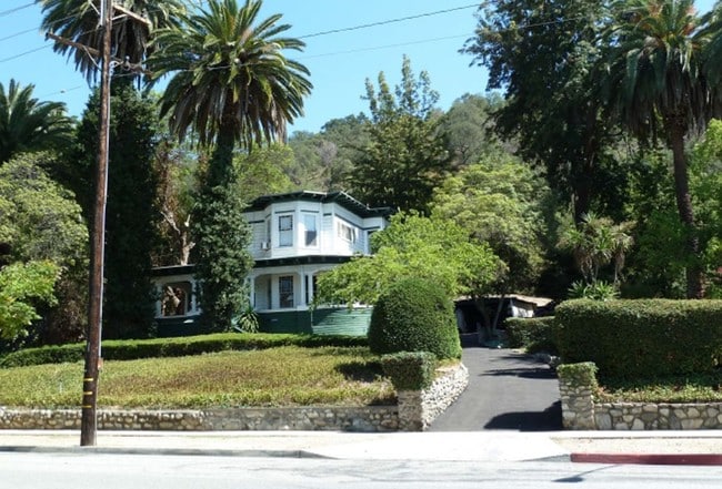
Property Record
0000, South Pasadena, CA 00000
NEARBY LISTINGS FOR SALE OR LEASE
Property Detail
0000
Los Angeles-Long Beach-Glendale, CA
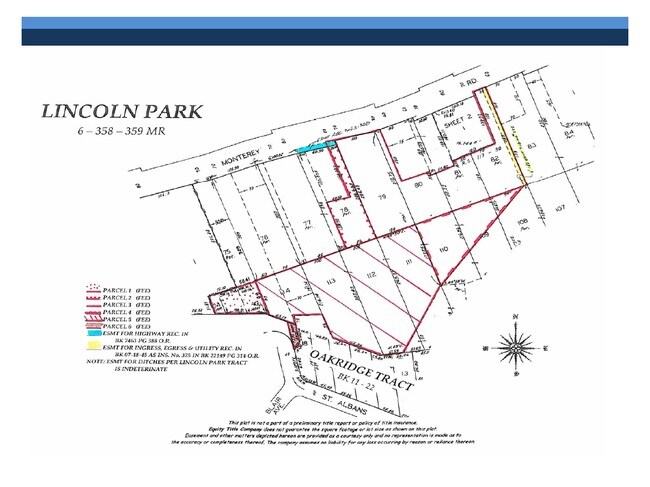
LINCOLN PARK LOT COM AT SE COR OF LOT 78 TH S 68 30 W 80 FT TH N 21 30 W 135.70 FT TH SE PARALLEL WITH NW LINE OF SD LOT 60.50 FT TH N 21 30 W 150.03 MORE OR LESS FT TO SE LINE OF MONTEREY RD TH SE MORE OR LESS FT TO BEG PART OF LOT 78
5311-015-034
Los Angeles
Residentialacreage
California
X
78
06037C1635F
0.10 AC
2024
Pasadena
2025
Los Angeles
480702
DEMOGRAPHICS near 0000
1 Mile
3 Mile
5 Mile
2024 Total Population
25,689
235,417
647,358
2029 Population
24,897
227,901
625,637
Pop Growth 2024-2029
(3.08%)
(3.19%)
(3.36%)
Average Age
41
41
41
2024 Total Households
9,795
87,704
229,811
HH Growth 2024-2029
(3.31%)
(3.39%)
(3.56%)
Median Household Inc
$109,603
$92,177
$80,060
Avg Household Size
2.60
2.60
2.70
2024 Avg HH Vehicles
2.00
2.00
2.00
Median Home Value
$1,003,384
$892,322
$860,593
Median Year Built
1960
1956
1957
Nearby Places
Map Layers
Map Styles
 Street
 Aerial
- Restaurants
- Banks
- Shops
- Fitness
- Groceries
PUBLIC TRANSPORTATION
COMMUTER RAIL
Glendale (Antelope Valley Line - Southern California Regional Rail Authority (Metrolink), Ventura County Line - Southern California Regional Rail Authority (Metrolink))
DRIVE
WALK
Distance
Glendale (Antelope Valley Line - Southern California Regional Rail Authority (Metrolink), Ventura County Line - Southern California Regional Rail Authority (Metrolink))
13 min
6.2 mi
AIRPORT
Bob Hope
DRIVE
WALK
Distance
Bob Hope
26 min
17.4 mi
Los Angeles International
DRIVE
WALK
Distance
Los Angeles International
35 min
21.7 mi
Long Beach (Daugherty Field)
DRIVE
WALK
Distance
Long Beach (Daugherty Field)
40 min
25.1 mi
Freight Ports
Port of Long Beach
DRIVE
WALK
Distance
Port of Long Beach
41 min
28.0 mi
Nearby Properties
Address
Land Use
TOTAL SIZE
Lot Size
Zoning
Address
Land Use
TOTAL SIZE
Lot Size
Zoning
874,871 SF
25.01 AC
PSC*
Address
Land Use
TOTAL SIZE
Lot Size
Zoning
1,067,590 SF
7.22 AC
PSC-
Address
Land Use
TOTAL SIZE
Lot Size
Zoning
534,225 SF
Address
Land Use
TOTAL SIZE
Lot Size
Zoning
460,590 SF
23.95 AC
ALMPD*
Address
Land Use
TOTAL SIZE
Lot Size
Zoning
11,590 SF
14.43 AC
PSC*
Address
Land Use
TOTAL SIZE
Lot Size
Zoning
251,317 SF
114.56 AC
LAR1
Address
Land Use
TOTAL SIZE
Lot Size
Zoning
516,474 SF
4.37 AC
ALCBD/DRD*
Address
Land Use
TOTAL SIZE
Lot Size
Zoning
588,972 SF
2.59 AC
PSC-
Address
Land Use
TOTAL SIZE
Lot Size
Zoning
372,451 SF
3.24 AC
PSC*
Address
Land Use
TOTAL SIZE
Lot Size
Zoning
246,000 SF
5.67 AC
PSC-
Address
Land Use
TOTAL SIZE
Lot Size
Zoning
91,145 SF
1.21 AC
PSC-
Address
Land Use
TOTAL SIZE
Lot Size
Zoning
100,653 SF
1.41 AC
PSC-
Address
Land Use
TOTAL SIZE
Lot Size
Zoning
119,455 SF
5.04 AC
LACM
Address
Land Use
TOTAL SIZE
Lot Size
Zoning
217,778 SF
1.81 AC
PSC-
Address
Land Use
TOTAL SIZE
Lot Size
Zoning
225,995 SF
10.86 AC
PSC2*
Address
Land Use
TOTAL SIZE
Lot Size
Zoning
345,558 SF
2.88 AC
PSC-
Address
Land Use
TOTAL SIZE
Lot Size
Zoning
158,307 SF
2.23 AC
PSC-
Address
Land Use
TOTAL SIZE
Lot Size
Zoning
130,553 SF
1.93 AC
PSR*
Address
Land Use
TOTAL SIZE
Lot Size
Zoning
52,970 SF
0.84 AC
PSC-
Address
Land Use
TOTAL SIZE
Lot Size
Zoning
241,167 SF
1.57 AC
PSCD
Address
Land Use
TOTAL SIZE
Lot Size
Zoning
75,577 SF
1.92 AC
PSC-
Address
Land Use
TOTAL SIZE
Lot Size
Zoning
118,260 SF
10.85 AC
PSC-
Address
Land Use
TOTAL SIZE
Lot Size
Zoning
187,132 SF
1.64 AC
PSC-
Address
Land Use
TOTAL SIZE
Lot Size
Zoning
65,757 SF
0.91 AC
PSC-
Address
Land Use
TOTAL SIZE
Lot Size
Zoning
158,996 SF
0.87 AC
PSC-
Address
Land Use
TOTAL SIZE
Lot Size
Zoning
100,611 SF
5.06 AC
PSC-
Address
Land Use
TOTAL SIZE
Lot Size
Zoning
25,161 SF
0.58 AC
PSC-
Address
Land Use
TOTAL SIZE
Lot Size
Zoning
264,405 SF
1.92 AC
PSCD
Address
Land Use
TOTAL SIZE
Lot Size
Zoning
87,738 SF
0.91 AC
PSC-
Address
Land Use
TOTAL SIZE
Lot Size
Zoning
122,517 SF
1.90 AC
PSC-
The World's #1 Commercial Real Estate Marketplace
Connect with us
© 2026 CoStar Group
The information above has been obtained from sources believed reliable. While we do not doubt its accuracy we have not verified it and make no guarantee, warranty or representation about it. It is your responsibility to independently confirm its accuracy and completeness. Any projections, opinions, assumptions, or estimates used are for example only and do not represent the current or future performance of the property. The value of this transaction to you depends on tax and other factors which should be evaluated by your tax, financial, and legal advisors. You and your advisors should conduct a careful, independent investigation of the property to determine to your satisfaction the suitability of the property for your needs.