Property Record
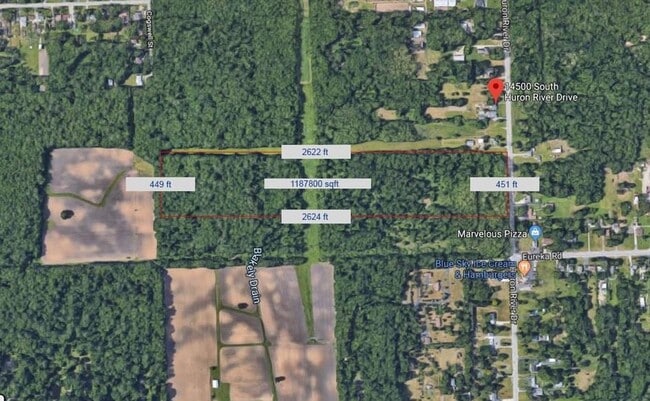
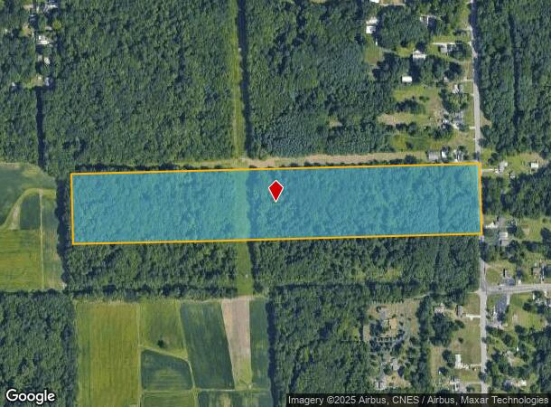
14500 S Huron River Dr, Romulus, MI 48174
This Property Is For Sale
NEARBY LISTINGS FOR SALE OR LEASE
Property Detail
14500 S Huron River Dr
Detroit-Warren-Dearborn, MI
30T2C1A PART OF SE 1/4 SEC 30 T3S R9E BEG AT S 1/4 COR SEC 30 T3S R9E TH N1DEG 20M W 798.97FT TH S89DEG 48M 50S E 2641.57FT
80-120-99-0010-001
Wayne
Residentialacreage
Michigan
X
0010
26163C0358E
26.83 AC
2024
Airport District
2025
Detroit
985400
DEMOGRAPHICS near 14500 S Huron River Dr
1 Mile
3 Mile
5 Mile
2024 Total Population
1,647
13,152
49,070
2029 Population
1,579
12,626
47,130
Pop Growth 2024-2029
(4.13%)
(4.00%)
(3.95%)
Average Age
42
42
40
2024 Total Households
631
5,407
19,876
HH Growth 2024-2029
(4.28%)
(3.98%)
(3.97%)
Median Household Inc
$74,870
$69,226
$70,301
Avg Household Size
2.60
2.40
2.40
2024 Avg HH Vehicles
2.00
2.00
2.00
Median Home Value
$175,493
$211,266
$211,276
Median Year Built
1963
1970
1976
Nearby Places
Map Layers
Map Styles
 Street
 Aerial
- Restaurants
- Banks
- Shops
- Fitness
- Groceries
PUBLIC TRANSPORTATION
AIRPORT
Detroit Metro Wayne County
DRIVE
WALK
Distance
Detroit Metro Wayne County
7 min
4.0 mi
Windsor International
DRIVE
WALK
Distance
Windsor International
53 min
32.4 mi
Freight Ports
Port of Toledo
DRIVE
WALK
Distance
Port of Toledo
58 min
45.7 mi
Nearby Properties
Address
Land Use
TOTAL SIZE
Lot Size
Zoning
Address
Land Use
TOTAL SIZE
Lot Size
Zoning
752,400 SF
72.97 AC
PDA
Address
Land Use
TOTAL SIZE
Lot Size
Zoning
516,762 SF
51.63 AC
PDA
Address
Land Use
TOTAL SIZE
Lot Size
Zoning
500,240 SF
M1-LIG
Address
Land Use
TOTAL SIZE
Lot Size
Zoning
146,562 SF
M2-GEN
Address
Land Use
TOTAL SIZE
Lot Size
Zoning
500,240 SF
55.95 AC
M2-GEN
Address
Land Use
TOTAL SIZE
Lot Size
Zoning
1,141,765 SF
154.21 AC
M2-GEN
Address
Land Use
TOTAL SIZE
Lot Size
Zoning
600,000 SF
M1-LIG
Address
Land Use
TOTAL SIZE
Lot Size
Zoning
199,922 SF
30.86 AC
M2-GEN
Address
Land Use
TOTAL SIZE
Lot Size
Zoning
250,263 SF
18.81 AC
RM-MLTI
Address
Land Use
TOTAL SIZE
Lot Size
Zoning
462,840 SF
45.66 AC
PDA
Address
Land Use
TOTAL SIZE
Lot Size
Zoning
161,794 SF
17.73 AC
RM MULT
Address
Land Use
TOTAL SIZE
Lot Size
Zoning
87,000 SF
18.02 AC
Address
Land Use
TOTAL SIZE
Lot Size
Zoning
88,790 SF
M2-GEN
Address
Land Use
TOTAL SIZE
Lot Size
Zoning
M1-LIG
Address
Land Use
TOTAL SIZE
Lot Size
Zoning
119,319 SF
10.23 AC
RM MULT
Address
Land Use
TOTAL SIZE
Lot Size
Zoning
201,184 SF
10.22 AC
M-2/PDA
Address
Land Use
TOTAL SIZE
Lot Size
Zoning
338,896 SF
14.35 AC
M2-GEN
Address
Land Use
TOTAL SIZE
Lot Size
Zoning
102,395 SF
11 AC
RM MULT
Address
Land Use
TOTAL SIZE
Lot Size
Zoning
65,518 SF
20.77 AC
R1A-S.F
Address
Land Use
TOTAL SIZE
Lot Size
Zoning
105,000 SF
15.26 AC
M2-GEN
Address
Land Use
TOTAL SIZE
Lot Size
Zoning
87,000 SF
17.20 AC
B1 LOCA
Address
Land Use
TOTAL SIZE
Lot Size
Zoning
88,790 SF
10.48 AC
M2-GEN
Address
Land Use
TOTAL SIZE
Lot Size
Zoning
79,895 SF
12.56 AC
M2-GEN
Address
Land Use
TOTAL SIZE
Lot Size
Zoning
174,163 SF
17.87 AC
M1 LIG
Address
Land Use
TOTAL SIZE
Lot Size
Zoning
157,099 SF
28.92 AC
M2-GEN
Address
Land Use
TOTAL SIZE
Lot Size
Zoning
117,695 SF
21.72 AC
M2-GEN
Address
Land Use
TOTAL SIZE
Lot Size
Zoning
88.62 AC
M1-LIG
Address
Land Use
TOTAL SIZE
Lot Size
Zoning
84,016 SF
8.44 AC
M2-GEN
Address
Land Use
TOTAL SIZE
Lot Size
Zoning
47.09 AC
I2 HEAV
Address
Land Use
TOTAL SIZE
Lot Size
Zoning
45,934 SF
35.95 AC
M2 GEN
The World's #1 Commercial Real Estate Marketplace
Connect with us
© 2025 CoStar Group
The information above has been obtained from sources believed reliable. While we do not doubt its accuracy we have not verified it and make no guarantee, warranty or representation about it. It is your responsibility to independently confirm its accuracy and completeness. Any projections, opinions, assumptions, or estimates used are for example only and do not represent the current or future performance of the property. The value of this transaction to you depends on tax and other factors which should be evaluated by your tax, financial, and legal advisors. You and your advisors should conduct a careful, independent investigation of the property to determine to your satisfaction the suitability of the property for your needs.