Property Record
1 W Main St, Ephrata, PA 17522
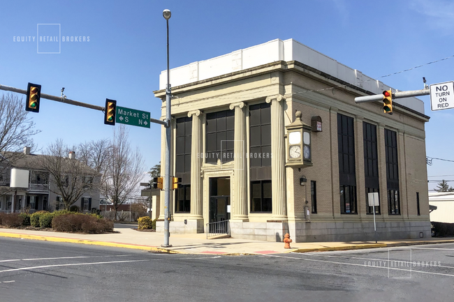

This Property Is For Sale
NEARBY LISTINGS FOR SALE OR LEASE
Property Detail
1 W Main St
Storebuilding
Lancaster
X
Pennsylvania
42071C0307F
0.29 AC
2024
Lancaster County
2025
Philadelphia
012301
Lancaster, PA
2,940 SF
450-14577-0-0000
DEMOGRAPHICS near 1 W Main St
1 Mile
3 Mile
5 Mile
2024 Total Population
6,950
18,282
46,027
2029 Population
7,016
18,460
46,372
Pop Growth 2024-2029
+ 0.95%
+ 0.97%
+ 0.75%
Average Age
43
43
42
2024 Total Households
3,002
7,806
18,266
HH Growth 2024-2029
+ 1.00%
+ 1.09%
+ 0.82%
Median Household Inc
$65,219
$75,812
$81,391
Avg Household Size
2.30
2.30
2.50
2024 Avg HH Vehicles
2.00
2.00
2.00
Median Home Value
$231,497
$256,013
$243,613
Median Year Built
1975
1986
1983
Nearby Places
Map Layers
Map Styles
 Street
 Aerial
- Restaurants
- Banks
- Shops
- Fitness
- Groceries
PUBLIC TRANSPORTATION
COMMUTER RAIL
Mount Joy Amtrak (Keystone Service - Amtrak)
DRIVE
WALK
Distance
Mount Joy Amtrak (Keystone Service - Amtrak)
0 min
1 min
0.1 mi
Elizabethtown Amtrak Station (Keystone Service - Amtrak, Pennsylvanian - Amtrak)
DRIVE
WALK
Distance
Elizabethtown Amtrak Station (Keystone Service - Amtrak, Pennsylvanian - Amtrak)
11 min
6.8 mi
AIRPORT
Harrisburg International
DRIVE
WALK
Distance
Harrisburg International
28 min
16.7 mi
Freight Ports
Port of Baltimore
DRIVE
WALK
Distance
Port of Baltimore
105 min
74.3 mi
Nearby Properties
Address
Land Use
TOTAL SIZE
Lot Size
Zoning
Address
Land Use
TOTAL SIZE
Lot Size
Zoning
431,583 SF
24.30 AC
R-2
Address
Land Use
TOTAL SIZE
Lot Size
Zoning
410,000 SF
30.35 AC
I
Address
Land Use
TOTAL SIZE
Lot Size
Zoning
125,610 SF
88.12 AC
A
Address
Land Use
TOTAL SIZE
Lot Size
Zoning
112,675 SF
61.94 AC
Address
Land Use
TOTAL SIZE
Lot Size
Zoning
302,400 SF
32.51 AC
I
Address
Land Use
TOTAL SIZE
Lot Size
Zoning
102,465 SF
17.14 AC
GC
Address
Land Use
TOTAL SIZE
Lot Size
Zoning
128,444 SF
33.65 AC
R-1
Address
Land Use
TOTAL SIZE
Lot Size
Zoning
55,728 SF
2.33 AC
Address
Land Use
TOTAL SIZE
Lot Size
Zoning
181,478 SF
20.96 AC
CI
Address
Land Use
TOTAL SIZE
Lot Size
Zoning
239,448 SF
28.74 AC
Address
Land Use
TOTAL SIZE
Lot Size
Zoning
231,575 SF
21.11 AC
I
Address
Land Use
TOTAL SIZE
Lot Size
Zoning
108,699 SF
65.62 AC
Address
Land Use
TOTAL SIZE
Lot Size
Zoning
120,757 SF
3 AC
TN
Address
Land Use
TOTAL SIZE
Lot Size
Zoning
91,050 SF
30.10 AC
MHDR
Address
Land Use
TOTAL SIZE
Lot Size
Zoning
50,904 SF
Address
Land Use
TOTAL SIZE
Lot Size
Zoning
49,730 SF
14 AC
I
Address
Land Use
TOTAL SIZE
Lot Size
Zoning
4,160 SF
101.10 AC
A
Address
Land Use
TOTAL SIZE
Lot Size
Zoning
70,515 SF
10.60 AC
HC
Address
Land Use
TOTAL SIZE
Lot Size
Zoning
57,780 SF
3.38 AC
R-2
Address
Land Use
TOTAL SIZE
Lot Size
Zoning
46,890 SF
1 AC
MDR
Address
Land Use
TOTAL SIZE
Lot Size
Zoning
61,606 SF
14.60 AC
A
Address
Land Use
TOTAL SIZE
Lot Size
Zoning
71,425 SF
1 AC
TN
Address
Land Use
TOTAL SIZE
Lot Size
Zoning
71,326 SF
1 AC
TN
Address
Land Use
TOTAL SIZE
Lot Size
Zoning
34,753 SF
10 AC
Address
Land Use
TOTAL SIZE
Lot Size
Zoning
99,821 SF
18.10 AC
I
Address
Land Use
TOTAL SIZE
Lot Size
Zoning
90,120 SF
17.92 AC
I
Address
Land Use
TOTAL SIZE
Lot Size
Zoning
44,696 SF
4.79 AC
R-3
Address
Land Use
TOTAL SIZE
Lot Size
Zoning
23,763 SF
13 AC
Address
Land Use
TOTAL SIZE
Lot Size
Zoning
48,454 SF
89.90 AC
A
Address
Land Use
TOTAL SIZE
Lot Size
Zoning
144,878 SF
22.50 AC
CI
The World's #1 Commercial Real Estate Marketplace
Connect with us
© 2025 CoStar Group
The information above has been obtained from sources believed reliable. While we do not doubt its accuracy we have not verified it and make no guarantee, warranty or representation about it. It is your responsibility to independently confirm its accuracy and completeness. Any projections, opinions, assumptions, or estimates used are for example only and do not represent the current or future performance of the property. The value of this transaction to you depends on tax and other factors which should be evaluated by your tax, financial, and legal advisors. You and your advisors should conduct a careful, independent investigation of the property to determine to your satisfaction the suitability of the property for your needs.