Property Record
1 Avocado Ln, Eustis, FL 32726
Property Detail
1 Avocado Ln
34-18-26-0004-000-01000
BEG SE COR OF W 1/2 OF SE 1/4 RUN W 440 FT N 02-01-0 E 38.82 FT S 88-57-50 W 146.13 FT TO HWY BEG AGAIN AT POB RUN N TO NE COR OF NW 1/4 OF SE 1/4 W TO RR SWLY ALONG RR TO PT 1240.41 FT NELY OF INTERSECTION OF ELY LINE OF RR WITH NELY LINE OF HWY 452
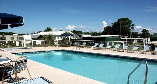
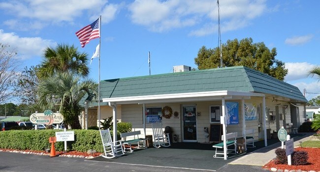
Campgroundrvpark
LAKE
A
Florida
A Areas with a 1% annual chance of flooding and a 26% chance of flooding over the life of a 30-year mortgage.
10
0
43.71 AC
2026
Lake County
030210
Orlando
12,573 SF
Orlando-Kissimmee-Sanford, FL
NEARBY LISTINGS FOR SALE OR LEASE
-
-
View all Eustis listings for sale on LoopNet.com
DEMOGRAPHICS near 1 Avocado Ln
1 mile
3 mile
5 mile
2025 Total Population
4,219
24,875
67,619
2030 Population
4,881
28,347
76,957
Pop Growth 2025-2030
+ 15.69%
+ 13.96%
+ 13.81%
Average Age
49
43
45
2025 Total Households
2,083
10,200
28,915
HH Growth 2025-2030
+ 16.23%
+ 14.27%
+ 14.05%
Median Household Inc
$39,674
$65,650
$64,198
Avg Household Size
2.00
2.40
2.30
2025 Avg HH Vehicles
2.00
2.00
2.00
Median Home Value
$207,113
$264,894
$266,400
Median Year Built
1988
1984
1986
Nearby Places
Map Layers
Map Styles
 Street
 Aerial
Transit
 Traffic
 Biking
Places
Listings with unknown addresses are not visible on the map
- Restaurants
- Banks
- Shops
- Fitness
- Groceries
PUBLIC TRANSPORTATION
AIRPORT
Orlando Sanford International
Drive
Walk
Distance
Orlando Sanford International
58 min
37.2 mi
Freight Ports
Port Canaveral
Drive
Walk
Distance
Port Canaveral
118 min
95.2 mi
Nearby Properties
Address
Land Use
TOTAL SIZE
Lot Size
Zoning
Address
Land Use
TOTAL SIZE
Lot Size
Zoning
174,744 SF
38.45 AC
GI
Address
Land Use
TOTAL SIZE
Lot Size
Zoning
60,476 SF
6.76 AC
MCR
Address
Land Use
TOTAL SIZE
Lot Size
Zoning
46,374 SF
6.96 AC
GC
Address
Land Use
TOTAL SIZE
Lot Size
Zoning
48,624 SF
12.01 AC
MCR
Address
Land Use
TOTAL SIZE
Lot Size
Zoning
2,000 SF
21.47 AC
SR
Address
Land Use
TOTAL SIZE
Lot Size
Zoning
113,572 SF
21.17 AC
LM
Address
Land Use
TOTAL SIZE
Lot Size
Zoning
43,472 SF
3.52 AC
UR
Address
Land Use
TOTAL SIZE
Lot Size
Zoning
65,868 SF
9.33 AC
MCR
Address
Land Use
TOTAL SIZE
Lot Size
Zoning
2,000 SF
35.84 AC
PI
Address
Land Use
TOTAL SIZE
Lot Size
Zoning
71.58 AC
Address
Land Use
TOTAL SIZE
Lot Size
Zoning
62,342 SF
5.12 AC
SR
Address
Land Use
TOTAL SIZE
Lot Size
Zoning
90,584 SF
11.14 AC
HM
Address
Land Use
TOTAL SIZE
Lot Size
Zoning
20,680 SF
0.47 AC
Address
Land Use
TOTAL SIZE
Lot Size
Zoning
776.54 AC
A
Address
Land Use
TOTAL SIZE
Lot Size
Zoning
34.62 AC
C2
Address
Land Use
TOTAL SIZE
Lot Size
Zoning
31,806 SF
9.46 AC
GI
Address
Land Use
TOTAL SIZE
Lot Size
Zoning
41,670 SF
2.93 AC
CP
Address
Land Use
TOTAL SIZE
Lot Size
Zoning
60,524 SF
9.61 AC
RP
Address
Land Use
TOTAL SIZE
Lot Size
Zoning
40,130 SF
4.88 AC
R6
Address
Land Use
TOTAL SIZE
Lot Size
Zoning
24,800 SF
13.08 AC
Address
Land Use
TOTAL SIZE
Lot Size
Zoning
23,424 SF
3.05 AC
Address
Land Use
TOTAL SIZE
Lot Size
Zoning
28,020 SF
4.48 AC
UR
Address
Land Use
TOTAL SIZE
Lot Size
Zoning
15,111 SF
2.14 AC
NC
Address
Land Use
TOTAL SIZE
Lot Size
Zoning
23,855 SF
1.61 AC
RT
Address
Land Use
TOTAL SIZE
Lot Size
Zoning
31,908 SF
1.59 AC
GC
Address
Land Use
TOTAL SIZE
Lot Size
Zoning
2,000 SF
30.97 AC
PI
Address
Land Use
TOTAL SIZE
Lot Size
Zoning
24,000 SF
2.67 AC
Address
Land Use
TOTAL SIZE
Lot Size
Zoning
23,506 SF
2.48 AC
R6
Address
Land Use
TOTAL SIZE
Lot Size
Zoning
43,368 SF
5.02 AC
UR
The World's #1 Commercial Real Estate Marketplace
Connect with us
© 2026 CoStar Group
The information above has been obtained from sources believed reliable. While we do not doubt its accuracy we have not verified it and make no guarantee, warranty or representation about it. It is your responsibility to independently confirm its accuracy and completeness. Any projections, opinions, assumptions, or estimates used are for example only and do not represent the current or future performance of the property. The value of this transaction to you depends on tax and other factors which should be evaluated by your tax, financial, and legal advisors. You and your advisors should conduct a careful, independent investigation of the property to determine to your satisfaction the suitability of the property for your needs.