Property Record
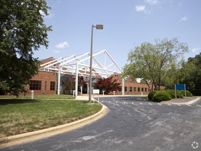
1 Becton Cir, Durham, NC 27712


Property Detail
1 Becton Cir
193007
PROP-CORNING INCORPORATED PL:207-362
Manufacturinglight
Durham
IL
North Carolina
AE The base floodplain where base flood elevations are provided. AE Zones are now used on new format FIRMs instead of A1-A30 Zones.
114.99 AC
2025
North Durham
2025
Raleigh/Durham
002100
Durham-Chapel Hill, NC
527,109 SF
NEARBY LISTINGS FOR SALE OR LEASE
-
-
View all Durham listings for sale on LoopNet.com
DEMOGRAPHICS near 1 Becton Cir
1 mile
3 mile
5 mile
2025 Total Population
154
9,451
47,026
2030 Population
160
9,874
49,348
Pop Growth 2025-2030
+ 3.90%
+ 4.48%
+ 4.94%
Average Age
47
44
40
2025 Total Households
54
3,406
17,042
HH Growth 2025-2030
+ 3.70%
+ 4.67%
+ 5.09%
Median Household Inc
$78,125
$97,040
$71,235
Avg Household Size
2.60
2.60
2.60
2025 Avg HH Vehicles
2.00
2.00
2.00
Median Home Value
$435,000
$390,076
$350,656
Median Year Built
1975
1991
1987
Nearby Places
Map Layers
Map Styles
 Street
 Aerial
Transit
 Traffic
 Biking
Places
Listings with unknown addresses are not visible on the map
- Restaurants
- Banks
- Shops
- Fitness
- Groceries
PUBLIC TRANSPORTATION
COMMUTER RAIL
Durham Amtrak Station (Carolinian - Amtrak, Piedmont - Amtrak)
Drive
Walk
Distance
Durham Amtrak Station (Carolinian - Amtrak, Piedmont - Amtrak)
21 min
8.8 mi
AIRPORT
Raleigh-Durham International
Drive
Walk
Distance
Raleigh-Durham International
35 min
21.7 mi
Freight Ports
Virginia Port Authority - Richmond
Drive
Walk
Distance
Virginia Port Authority - Richmond
168 min
144.9 mi
Nearby Properties
Address
Land Use
TOTAL SIZE
Lot Size
Zoning
Address
Land Use
TOTAL SIZE
Lot Size
Zoning
906,736 SF
258.08 AC
IL
Address
Land Use
TOTAL SIZE
Lot Size
Zoning
851,552 SF
123.42 AC
IL
Address
Land Use
TOTAL SIZE
Lot Size
Zoning
385,175 SF
130.35 AC
SRP
Address
Land Use
TOTAL SIZE
Lot Size
Zoning
139,872 SF
49.06 AC
IL
Address
Land Use
TOTAL SIZE
Lot Size
Zoning
1,661.50 AC
RR
Address
Land Use
TOTAL SIZE
Lot Size
Zoning
98,638 SF
24.59 AC
IL
Address
Land Use
TOTAL SIZE
Lot Size
Zoning
156,483 SF
31.52 AC
RR
Address
Land Use
TOTAL SIZE
Lot Size
Zoning
187,680 SF
38.82 AC
Address
Land Use
TOTAL SIZE
Lot Size
Zoning
209,900 SF
30.20 AC
RR
Address
Land Use
TOTAL SIZE
Lot Size
Zoning
85,651 SF
23.23 AC
PDR 2.240
Address
Land Use
TOTAL SIZE
Lot Size
Zoning
89,440 SF
15 AC
IL
Address
Land Use
TOTAL SIZE
Lot Size
Zoning
120.14 AC
IL
Address
Land Use
TOTAL SIZE
Lot Size
Zoning
475.76 AC
RR
Address
Land Use
TOTAL SIZE
Lot Size
Zoning
225,877 SF
87.41 AC
Address
Land Use
TOTAL SIZE
Lot Size
Zoning
405.60 AC
RR
Address
Land Use
TOTAL SIZE
Lot Size
Zoning
70.44 AC
RS-20
Address
Land Use
TOTAL SIZE
Lot Size
Zoning
50,864 SF
10.04 AC
PDR 2.240
Address
Land Use
TOTAL SIZE
Lot Size
Zoning
57.10 AC
IL (D)
Address
Land Use
TOTAL SIZE
Lot Size
Zoning
11,740 SF
249.03 AC
RR,RS-20
Address
Land Use
TOTAL SIZE
Lot Size
Zoning
47.92 AC
IL (D)
Address
Land Use
TOTAL SIZE
Lot Size
Zoning
11,881 SF
14.25 AC
IL
Address
Land Use
TOTAL SIZE
Lot Size
Zoning
38,702 SF
210.53 AC
PDR 2.240
Address
Land Use
TOTAL SIZE
Lot Size
Zoning
50.18 AC
IL
Address
Land Use
TOTAL SIZE
Lot Size
Zoning
109.05 AC
IL
Address
Land Use
TOTAL SIZE
Lot Size
Zoning
70,080 SF
19.50 AC
IL
Address
Land Use
TOTAL SIZE
Lot Size
Zoning
41,121 SF
28.04 AC
IL
Address
Land Use
TOTAL SIZE
Lot Size
Zoning
27,000 SF
10.02 AC
IL
Address
Land Use
TOTAL SIZE
Lot Size
Zoning
249.49 AC
RR
Address
Land Use
TOTAL SIZE
Lot Size
Zoning
244.77 AC
RR
The World's #1 Commercial Real Estate Marketplace
Connect with us
© 2026 CoStar Group
The information above has been obtained from sources believed reliable. While we do not doubt its accuracy we have not verified it and make no guarantee, warranty or representation about it. It is your responsibility to independently confirm its accuracy and completeness. Any projections, opinions, assumptions, or estimates used are for example only and do not represent the current or future performance of the property. The value of this transaction to you depends on tax and other factors which should be evaluated by your tax, financial, and legal advisors. You and your advisors should conduct a careful, independent investigation of the property to determine to your satisfaction the suitability of the property for your needs.