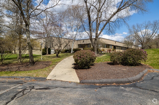
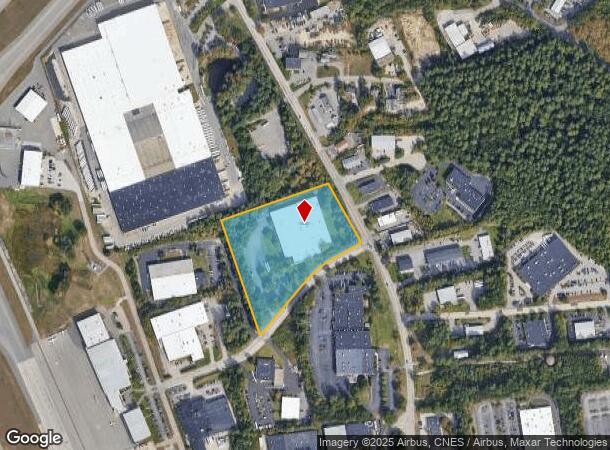
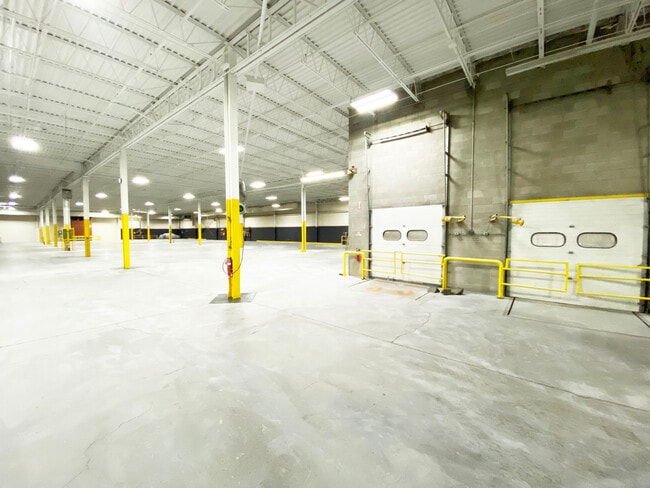
Property Record
1 Bouchard St, Manchester, NH 03103
Current Lease Availabilities
NEARBY LISTINGS FOR SALE OR LEASE
Property Detail
1 Bouchard St
MNCH-000721-000000-000005
Hillsborough
Warehouse
New Hampshire
X
5
33011C0395D
7.72 AC
2024
Hillsborough
2024
Boston
980101
Manchester-Nashua, NH
83,184 SF
DEMOGRAPHICS near 1 Bouchard St
1 Mile
3 Mile
5 Mile
2024 Total Population
636
35,614
125,156
2029 Population
673
36,458
127,635
Pop Growth 2024-2029
+ 5.82%
+ 2.37%
+ 1.98%
Average Age
44
41
40
2024 Total Households
265
14,468
50,896
HH Growth 2024-2029
+ 6.04%
+ 2.38%
+ 1.96%
Median Household Inc
$78,030
$83,465
$79,206
Avg Household Size
2.40
2.40
2.40
2024 Avg HH Vehicles
2.00
2.00
2.00
Median Home Value
$304,762
$310,173
$335,653
Median Year Built
1989
1978
1971
Nearby Places
- Restaurants
- Banks
- Shops
- Fitness
- Groceries
PUBLIC TRANSPORTATION
AIRPORT
Manchester Boston Regional
DRIVE
WALK
Distance
Manchester Boston Regional
12 min
4.5 mi
Freight Ports
Port of Boston
DRIVE
WALK
Distance
Port of Boston
79 min
51.9 mi
Nearby Properties
Address
Land Use
TOTAL SIZE
Lot Size
Zoning
Address
Land Use
TOTAL SIZE
Lot Size
Zoning
768,020 SF
74.47 AC
I-II
Address
Land Use
TOTAL SIZE
Lot Size
Zoning
383,493 SF
34.51 AC
Address
Land Use
TOTAL SIZE
Lot Size
Zoning
603,357 SF
45.12 AC
GB
Address
Land Use
TOTAL SIZE
Lot Size
Zoning
8,064 SF
34.29 AC
Address
Land Use
TOTAL SIZE
Lot Size
Zoning
46,906 SF
552.35 AC
Address
Land Use
TOTAL SIZE
Lot Size
Zoning
29,803 SF
31.46 AC
PZ
Address
Land Use
TOTAL SIZE
Lot Size
Zoning
3,748 SF
14.69 AC
Address
Land Use
TOTAL SIZE
Lot Size
Zoning
0.60 AC
PZ
Address
Land Use
TOTAL SIZE
Lot Size
Zoning
217,697 SF
43.25 AC
Address
Land Use
TOTAL SIZE
Lot Size
Zoning
42,228 SF
15.58 AC
PZ
Address
Land Use
TOTAL SIZE
Lot Size
Zoning
50.47 AC
GB
Address
Land Use
TOTAL SIZE
Lot Size
Zoning
22,101 SF
8.33 AC
Address
Land Use
TOTAL SIZE
Lot Size
Zoning
723,875 SF
38.08 AC
Address
Land Use
TOTAL SIZE
Lot Size
Zoning
49,788 SF
34.73 AC
Address
Land Use
TOTAL SIZE
Lot Size
Zoning
180,600 SF
14.19 AC
IND-I
Address
Land Use
TOTAL SIZE
Lot Size
Zoning
366,008 SF
41.69 AC
IND-I
Address
Land Use
TOTAL SIZE
Lot Size
Zoning
487,970 SF
79.74 AC
IND-I
Address
Land Use
TOTAL SIZE
Lot Size
Zoning
201,831 SF
18.46 AC
IND-II
Address
Land Use
TOTAL SIZE
Lot Size
Zoning
151,002 SF
6.95 AC
PZ
Address
Land Use
TOTAL SIZE
Lot Size
Zoning
139,616 SF
18.47 AC
PZ
Address
Land Use
TOTAL SIZE
Lot Size
Zoning
119,139 SF
25.87 AC
IND-I
Address
Land Use
TOTAL SIZE
Lot Size
Zoning
142,318 SF
26.13 AC
GB
Address
Land Use
TOTAL SIZE
Lot Size
Zoning
180,474 SF
18.60 AC
Address
Land Use
TOTAL SIZE
Lot Size
Zoning
227,589 SF
GB
Address
Land Use
TOTAL SIZE
Lot Size
Zoning
244,637 SF
27.28 AC
IND-II
Address
Land Use
TOTAL SIZE
Lot Size
Zoning
304,312 SF
29.62 AC
IND-II
Address
Land Use
TOTAL SIZE
Lot Size
Zoning
Address
Land Use
TOTAL SIZE
Lot Size
Zoning
171,811 SF
44.42 AC
Address
Land Use
TOTAL SIZE
Lot Size
Zoning
13,395 SF
8.16 AC
PZ
Address
Land Use
TOTAL SIZE
Lot Size
Zoning
6,110 SF
12.99 AC
The World's #1 Commercial Real Estate Marketplace
Connect with us
© 2025 CoStar Group
The information above has been obtained from sources believed reliable. While we do not doubt its accuracy we have not verified it and make no guarantee, warranty or representation about it. It is your responsibility to independently confirm its accuracy and completeness. Any projections, opinions, assumptions, or estimates used are for example only and do not represent the current or future performance of the property. The value of this transaction to you depends on tax and other factors which should be evaluated by your tax, financial, and legal advisors. You and your advisors should conduct a careful, independent investigation of the property to determine to your satisfaction the suitability of the property for your needs.