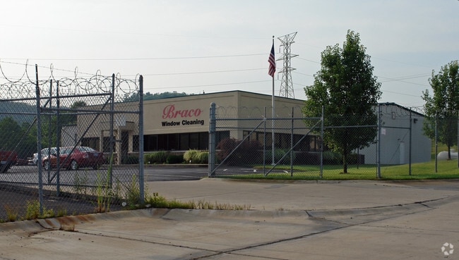
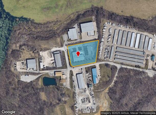
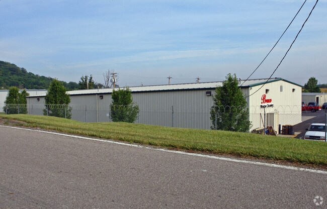
Property Record
1 Braco Int Blvd, Wilder, KY 41076
NEARBY LISTINGS FOR SALE OR LEASE
Property Detail
1 Braco Int Blvd
Cincinnati, OH-KY-IN
Vine Street Industrial Subdivision
999-99-20-164.01
VINE ST INDUSTRIAL SUBD LOT 1 1.926 ACRES
Commercialnec
Campbell
X
Kentucky
21037C0038E
1
2024
1.93 AC
2025
Campbell County
053302
Cincinnati/Dayton
9,975 SF
DEMOGRAPHICS near 1 Braco Int Blvd
1 Mile
3 Mile
5 Mile
2024 Total Population
2,702
44,773
139,659
2029 Population
2,741
45,520
142,490
Pop Growth 2024-2029
+ 1.44%
+ 1.67%
+ 2.03%
Average Age
42
40
40
2024 Total Households
1,084
19,313
59,776
HH Growth 2024-2029
+ 1.29%
+ 1.61%
+ 2.09%
Median Household Inc
$68,099
$56,697
$67,068
Avg Household Size
2.30
2.20
2.20
2024 Avg HH Vehicles
2.00
2.00
2.00
Median Home Value
$188,795
$181,827
$227,033
Median Year Built
1970
1972
1965
Nearby Places
Map Layers
Map Styles
 Street
 Aerial
- Restaurants
- Banks
- Shops
- Fitness
- Groceries
PUBLIC TRANSPORTATION
AIRPORT
Cincinnati/Northern Kentucky International
DRIVE
WALK
Distance
Cincinnati/Northern Kentucky International
23 min
12.7 mi
Nearby Properties
Address
Land Use
TOTAL SIZE
Lot Size
Zoning
Address
Land Use
TOTAL SIZE
Lot Size
Zoning
560 SF
218.94 AC
Address
Land Use
TOTAL SIZE
Lot Size
Zoning
243,000 SF
11.30 AC
Address
Land Use
TOTAL SIZE
Lot Size
Zoning
0.95 AC
Address
Land Use
TOTAL SIZE
Lot Size
Zoning
0.83 AC
Address
Land Use
TOTAL SIZE
Lot Size
Zoning
0.74 AC
Address
Land Use
TOTAL SIZE
Lot Size
Zoning
0.71 AC
Address
Land Use
TOTAL SIZE
Lot Size
Zoning
0.71 AC
Address
Land Use
TOTAL SIZE
Lot Size
Zoning
360,000 SF
Address
Land Use
TOTAL SIZE
Lot Size
Zoning
0.53 AC
Address
Land Use
TOTAL SIZE
Lot Size
Zoning
0.56 AC
Address
Land Use
TOTAL SIZE
Lot Size
Zoning
0.57 AC
Address
Land Use
TOTAL SIZE
Lot Size
Zoning
0.49 AC
Address
Land Use
TOTAL SIZE
Lot Size
Zoning
0.59 AC
Address
Land Use
TOTAL SIZE
Lot Size
Zoning
25.08 AC
Address
Land Use
TOTAL SIZE
Lot Size
Zoning
0.48 AC
Address
Land Use
TOTAL SIZE
Lot Size
Zoning
0.40 AC
Address
Land Use
TOTAL SIZE
Lot Size
Zoning
441,907 SF
Address
Land Use
TOTAL SIZE
Lot Size
Zoning
1,049,050 SF
8.60 AC
Address
Land Use
TOTAL SIZE
Lot Size
Zoning
0.33 AC
Address
Land Use
TOTAL SIZE
Lot Size
Zoning
20.49 AC
Address
Land Use
TOTAL SIZE
Lot Size
Zoning
15.05 AC
Address
Land Use
TOTAL SIZE
Lot Size
Zoning
12.60 AC
Address
Land Use
TOTAL SIZE
Lot Size
Zoning
7.82 AC
Address
Land Use
TOTAL SIZE
Lot Size
Zoning
Address
Land Use
TOTAL SIZE
Lot Size
Zoning
20.01 AC
Address
Land Use
TOTAL SIZE
Lot Size
Zoning
1,800 SF
10.18 AC
Address
Land Use
TOTAL SIZE
Lot Size
Zoning
15,570 SF
21.35 AC
Address
Land Use
TOTAL SIZE
Lot Size
Zoning
25.96 AC
Address
Land Use
TOTAL SIZE
Lot Size
Zoning
179,770 SF
Address
Land Use
TOTAL SIZE
Lot Size
Zoning
18,288 SF
41.21 AC
The World's #1 Commercial Real Estate Marketplace
Connect with us
© 2025 CoStar Group
The information above has been obtained from sources believed reliable. While we do not doubt its accuracy we have not verified it and make no guarantee, warranty or representation about it. It is your responsibility to independently confirm its accuracy and completeness. Any projections, opinions, assumptions, or estimates used are for example only and do not represent the current or future performance of the property. The value of this transaction to you depends on tax and other factors which should be evaluated by your tax, financial, and legal advisors. You and your advisors should conduct a careful, independent investigation of the property to determine to your satisfaction the suitability of the property for your needs.