Property Record
1 Brook Valley Ter, Kinnelon, NJ 07405
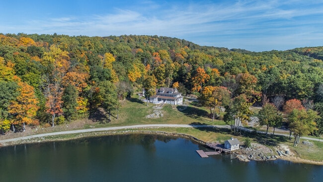
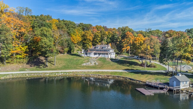

This Property Is For Sale
NEARBY LISTINGS FOR SALE OR LEASE
Property Detail
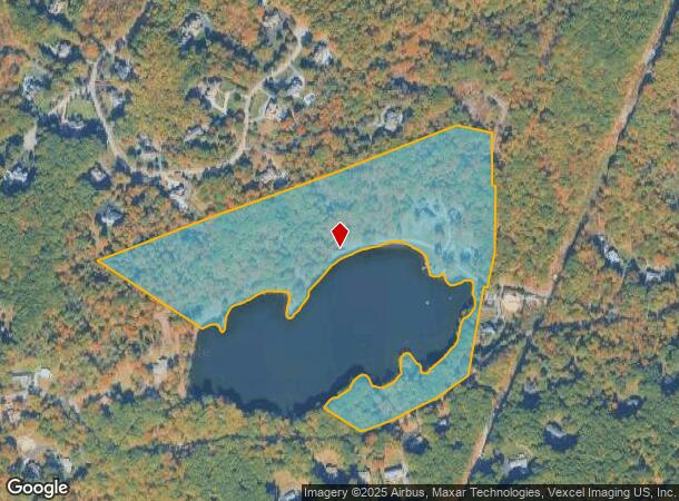
1 Brook Valley Ter
Newark, NJ-PA
Morris
15-56701-0000-00103
New Jersey
Farms
103
2024
3 AC
2025
Eastern Morris
040701
Northern New Jersey
6,130 SF
DEMOGRAPHICS near 1 Brook Valley Ter
1 Mile
3 Mile
5 Mile
2024 Total Population
1,197
29,275
108,440
2029 Population
1,196
29,259
108,009
Pop Growth 2024-2029
(0.08%)
(0.05%)
(0.40%)
Average Age
44
45
43
2024 Total Households
404
11,133
40,423
HH Growth 2024-2029
(0.25%)
(0.19%)
(0.51%)
Median Household Inc
$200,985
$128,832
$119,061
Avg Household Size
3.00
2.60
2.60
2024 Avg HH Vehicles
3.00
2.00
2.00
Median Home Value
$725,000
$552,631
$476,597
Median Year Built
1976
1970
1967
Nearby Places
Map Layers
Map Styles
 Street
 Aerial
- Restaurants
- Banks
- Shops
- Fitness
- Groceries
PUBLIC TRANSPORTATION
COMMUTER RAIL
Towaco (Montclair-Boonton Line - NJ Transit Commuter Rail (NJ Transit))
DRIVE
WALK
Distance
Towaco (Montclair-Boonton Line - NJ Transit Commuter Rail (NJ Transit))
12 min
4.1 mi
Lincoln Park (Montclair-Boonton Line - NJ Transit Commuter Rail (NJ Transit))
DRIVE
WALK
Distance
Lincoln Park (Montclair-Boonton Line - NJ Transit Commuter Rail (NJ Transit))
16 min
6.3 mi
AIRPORT
Newark Liberty International
DRIVE
WALK
Distance
Newark Liberty International
44 min
31.2 mi
LaGuardia
DRIVE
WALK
Distance
LaGuardia
60 min
39.2 mi
Freight Ports
Port Newark Container Terminal
DRIVE
WALK
Distance
Port Newark Container Terminal
50 min
30.5 mi
Nearby Properties
Address
Land Use
TOTAL SIZE
Lot Size
Zoning
Address
Land Use
TOTAL SIZE
Lot Size
Zoning
143.16 AC
PUD
Address
Land Use
TOTAL SIZE
Lot Size
Zoning
32.21 AC
R-15
Address
Land Use
TOTAL SIZE
Lot Size
Zoning
5,880 SF
17.46 AC
I
Address
Land Use
TOTAL SIZE
Lot Size
Zoning
49,925 SF
4.08 AC
R-4
Address
Land Use
TOTAL SIZE
Lot Size
Zoning
25,064 SF
14.53 AC
HB
Address
Land Use
TOTAL SIZE
Lot Size
Zoning
131,306 SF
14.40 AC
HB
Address
Land Use
TOTAL SIZE
Lot Size
Zoning
10.07 AC
R-15
Address
Land Use
TOTAL SIZE
Lot Size
Zoning
109,848 SF
14.01 AC
HB
Address
Land Use
TOTAL SIZE
Lot Size
Zoning
13.72 AC
RO
Address
Land Use
TOTAL SIZE
Lot Size
Zoning
634 SF
14.76 AC
H
Address
Land Use
TOTAL SIZE
Lot Size
Zoning
23.15 AC
R
Address
Land Use
TOTAL SIZE
Lot Size
Zoning
70,398 SF
6.14 AC
HB
Address
Land Use
TOTAL SIZE
Lot Size
Zoning
10.97 AC
R-15
Address
Land Use
TOTAL SIZE
Lot Size
Zoning
54,176 SF
21.48 AC
R-4
Address
Land Use
TOTAL SIZE
Lot Size
Zoning
7.54 AC
R-15
Address
Land Use
TOTAL SIZE
Lot Size
Zoning
8.98 AC
R-11
Address
Land Use
TOTAL SIZE
Lot Size
Zoning
4,320 SF
11.59 AC
PRD
Address
Land Use
TOTAL SIZE
Lot Size
Zoning
114,540 SF
2.57 AC
OB2B
Address
Land Use
TOTAL SIZE
Lot Size
Zoning
112,860 SF
2.39 AC
HB
Address
Land Use
TOTAL SIZE
Lot Size
Zoning
11.51 AC
R
Address
Land Use
TOTAL SIZE
Lot Size
Zoning
26.36 AC
R
Address
Land Use
TOTAL SIZE
Lot Size
Zoning
1,434 SF
6.10 AC
I
Address
Land Use
TOTAL SIZE
Lot Size
Zoning
54,944 SF
4.89 AC
I
Address
Land Use
TOTAL SIZE
Lot Size
Zoning
91,880 SF
24.54 AC
I2
Address
Land Use
TOTAL SIZE
Lot Size
Zoning
2.97 AC
I-2
Address
Land Use
TOTAL SIZE
Lot Size
Zoning
44,440 SF
1.42 AC
R40
Address
Land Use
TOTAL SIZE
Lot Size
Zoning
18,352 SF
4.19 AC
OB2A
Address
Land Use
TOTAL SIZE
Lot Size
Zoning
8.53 AC
AG-1
Address
Land Use
TOTAL SIZE
Lot Size
Zoning
44.61 AC
I1A
Address
Land Use
TOTAL SIZE
Lot Size
Zoning
43,862 SF
4.01 AC
TI
The World's #1 Commercial Real Estate Marketplace
Connect with us
© 2025 CoStar Group
The information above has been obtained from sources believed reliable. While we do not doubt its accuracy we have not verified it and make no guarantee, warranty or representation about it. It is your responsibility to independently confirm its accuracy and completeness. Any projections, opinions, assumptions, or estimates used are for example only and do not represent the current or future performance of the property. The value of this transaction to you depends on tax and other factors which should be evaluated by your tax, financial, and legal advisors. You and your advisors should conduct a careful, independent investigation of the property to determine to your satisfaction the suitability of the property for your needs.