Property Record
1 Cirrus Dr, Ashland, MA 01721
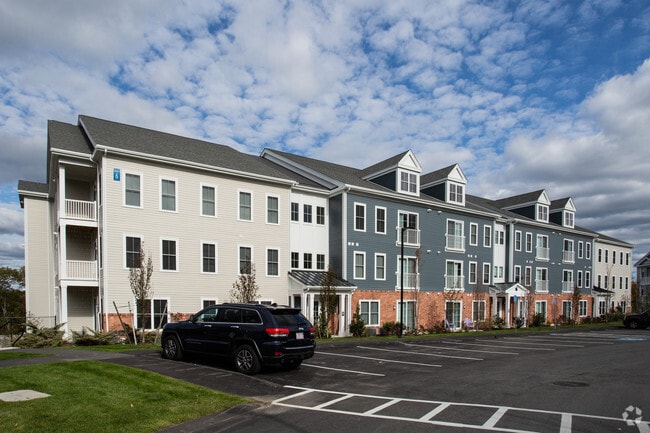
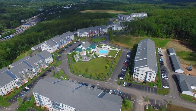
Property Detail
1 Cirrus Dr
Apartment
MIDDLESEX
R4
Massachusetts
B and X Area of moderate flood hazard, usually the area between the limits of the 100-year and 500-year floods.
28.44 AC
2025
495-South
2025
Boston
385204
Boston-Cambridge-Newton, MA-NH
556,849 SF
ASHL-0140130015200000
NEARBY LISTINGS FOR SALE OR LEASE
-
-
View all Ashland listings for sale on LoopNet.com
DEMOGRAPHICS near 1 Cirrus Dr
1 mile
3 mile
5 mile
2025 Total Population
4,733
38,657
116,200
2030 Population
4,904
40,393
121,374
Pop Growth 2025-2030
+ 3.61%
+ 4.49%
+ 4.45%
Average Age
41
41
40
2025 Total Households
1,827
14,945
42,951
HH Growth 2025-2030
+ 3.67%
+ 4.73%
+ 4.61%
Median Household Inc
$139,953
$138,877
$120,514
Avg Household Size
2.60
2.50
2.60
2025 Avg HH Vehicles
2.00
2.00
2.00
Median Home Value
$752,157
$721,544
$722,092
Median Year Built
1996
1982
1973
Nearby Places
Map Layers
Map Styles
 Street
 Aerial
Layers
 Traffic
 Biking
Places
Listings with unknown addresses are not visible on the map
- Restaurants
- Banks
- Shops
- Fitness
- Groceries
PUBLIC TRANSPORTATION
COMMUTER RAIL
Ashland (Framingham/Worcester Line - Massachusetts Bay Transportation Authority Commuter Rail (Purple Line))
Drive
Walk
Distance
Ashland (Framingham/Worcester Line - Massachusetts Bay Transportation Authority Commuter Rail (Purple Line))
4 min
16 min
0.8 mi
Southborough (Framingham/Worcester Line - Massachusetts Bay Transportation Authority Commuter Rail (Purple Line))
Drive
Walk
Distance
Southborough (Framingham/Worcester Line - Massachusetts Bay Transportation Authority Commuter Rail (Purple Line))
13 min
4.9 mi
AIRPORT
Worcester Regional
Drive
Walk
Distance
Worcester Regional
48 min
25.9 mi
General Edward Lawrence Logan International
Drive
Walk
Distance
General Edward Lawrence Logan International
52 min
29.5 mi
Freight Ports
Port of Boston
Drive
Walk
Distance
Port of Boston
50 min
27.8 mi
Nearby Properties
Address
Land Use
TOTAL SIZE
Lot Size
Zoning
Address
Land Use
TOTAL SIZE
Lot Size
Zoning
51.50 AC
A2
Address
Land Use
TOTAL SIZE
Lot Size
Zoning
906,841 SF
47.93 AC
M1
Address
Land Use
TOTAL SIZE
Lot Size
Zoning
664,397 SF
15.78 AC
TP
Address
Land Use
TOTAL SIZE
Lot Size
Zoning
18.22 AC
OSMU
Address
Land Use
TOTAL SIZE
Lot Size
Zoning
340,840 SF
4.25 AC
B
Address
Land Use
TOTAL SIZE
Lot Size
Zoning
292,608 SF
5.19 AC
B
Address
Land Use
TOTAL SIZE
Lot Size
Zoning
293,180 SF
5.10 AC
B
Address
Land Use
TOTAL SIZE
Lot Size
Zoning
191,520 SF
7.99 AC
B
Address
Land Use
TOTAL SIZE
Lot Size
Zoning
191,520 SF
5.03 AC
B
Address
Land Use
TOTAL SIZE
Lot Size
Zoning
244,033 SF
25.75 AC
R1
Address
Land Use
TOTAL SIZE
Lot Size
Zoning
139,356 SF
52 AC
30
Address
Land Use
TOTAL SIZE
Lot Size
Zoning
174,988 SF
5.54 AC
TP
Address
Land Use
TOTAL SIZE
Lot Size
Zoning
15,204 SF
5.79 AC
BH
Address
Land Use
TOTAL SIZE
Lot Size
Zoning
150,636 SF
30.34 AC
GE
Address
Land Use
TOTAL SIZE
Lot Size
Zoning
154,724 SF
39.70 AC
R3
Address
Land Use
TOTAL SIZE
Lot Size
Zoning
289,642 SF
8.13 AC
M
Address
Land Use
TOTAL SIZE
Lot Size
Zoning
25.20 AC
A
Address
Land Use
TOTAL SIZE
Lot Size
Zoning
202,609 SF
1.70 AC
TP
Address
Land Use
TOTAL SIZE
Lot Size
Zoning
42,000 SF
3.82 AC
30
Address
Land Use
TOTAL SIZE
Lot Size
Zoning
82,554 SF
11.15 AC
RB
Address
Land Use
TOTAL SIZE
Lot Size
Zoning
149,806 SF
11.20 AC
B
Address
Land Use
TOTAL SIZE
Lot Size
Zoning
121,889 SF
2.01 AC
M1
Address
Land Use
TOTAL SIZE
Lot Size
Zoning
101,140 SF
10 AC
TP
Address
Land Use
TOTAL SIZE
Lot Size
Zoning
6,420 SF
28 AC
IP
Address
Land Use
TOTAL SIZE
Lot Size
Zoning
237,486 SF
18.61 AC
TP
Address
Land Use
TOTAL SIZE
Lot Size
Zoning
122,031 SF
4.90 AC
B
Address
Land Use
TOTAL SIZE
Lot Size
Zoning
90,256 SF
14.48 AC
R4
Address
Land Use
TOTAL SIZE
Lot Size
Zoning
226,884 SF
6.16 AC
WMUSD
Address
Land Use
TOTAL SIZE
Lot Size
Zoning
113,540 SF
5.89 AC
CS
The World's #1 Commercial Real Estate Marketplace
Connect with us
© 2026 CoStar Group
The information above has been obtained from sources believed reliable. While we do not doubt its accuracy we have not verified it and make no guarantee, warranty or representation about it. It is your responsibility to independently confirm its accuracy and completeness. Any projections, opinions, assumptions, or estimates used are for example only and do not represent the current or future performance of the property. The value of this transaction to you depends on tax and other factors which should be evaluated by your tax, financial, and legal advisors. You and your advisors should conduct a careful, independent investigation of the property to determine to your satisfaction the suitability of the property for your needs.