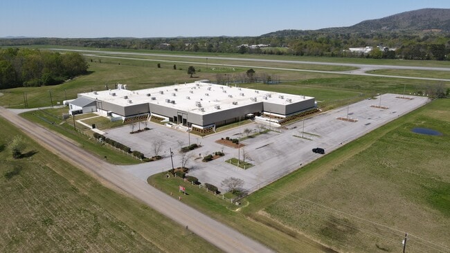
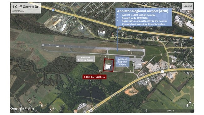
Property Record
1 Cliff Garrett Dr, Oxford, AL 36203

NEARBY LISTINGS FOR SALE OR LEASE
Property Detail
1 Cliff Garrett Dr
22-07-36-0-006-064.002
SEC 36 TSP 16S RNG 07E BEG 1800 W & 160 N OF SE COR SEC 36 TH NW 726 NE 600 SE 726 SW 600 TO POB OXFORD AL
Storebuilding
Calhoun
AE
Alabama
01015C0403E
10 AC
0
Gadsden/Anniston Area
2025
Other Market Areas
001103
Anniston-Oxford-Jacksonville, AL
81,920 SF
DEMOGRAPHICS near 1 Cliff Garrett Dr
1 Mile
3 Mile
5 Mile
2024 Total Population
1,602
14,387
30,940
2029 Population
1,552
14,038
30,424
Pop Growth 2024-2029
(3.12%)
(2.43%)
(1.67%)
Average Age
39
40
41
2024 Total Households
610
5,529
12,152
HH Growth 2024-2029
(3.11%)
(2.62%)
(1.79%)
Median Household Inc
$63,786
$54,730
$53,091
Avg Household Size
2.60
2.50
2.40
2024 Avg HH Vehicles
2.00
2.00
2.00
Median Home Value
$136,301
$157,946
$147,830
Median Year Built
1977
1980
1978
Nearby Places
Map Layers
Map Styles
 Street
 Aerial
- Restaurants
- Banks
- Shops
- Fitness
- Groceries
PUBLIC TRANSPORTATION
COMMUTER RAIL
DRIVE
WALK
Distance
11 min
5.5 mi
SALE & LEASE HISTORY
LISTING DATE
SALE/LEASE

Sep 06, 2022
For Lease
Jan 27, 2021
For Lease
Feb 17, 2022
For Sale
Nearby Properties
Address
Land Use
TOTAL SIZE
Lot Size
Zoning
Address
Land Use
TOTAL SIZE
Lot Size
Zoning
128,399 SF
17 AC
Address
Land Use
TOTAL SIZE
Lot Size
Zoning
7,752 SF
182 AC
Address
Land Use
TOTAL SIZE
Lot Size
Zoning
1,972 SF
22.80 AC
Address
Land Use
TOTAL SIZE
Lot Size
Zoning
87,750 SF
25 AC
Address
Land Use
TOTAL SIZE
Lot Size
Zoning
201,670 SF
27.50 AC
Address
Land Use
TOTAL SIZE
Lot Size
Zoning
14,015 SF
8.50 AC
Address
Land Use
TOTAL SIZE
Lot Size
Zoning
12,695 SF
0.75 AC
Address
Land Use
TOTAL SIZE
Lot Size
Zoning
31,104 SF
36 AC
Address
Land Use
TOTAL SIZE
Lot Size
Zoning
128,064 SF
7.70 AC
Address
Land Use
TOTAL SIZE
Lot Size
Zoning
82,787 SF
8.55 AC
Address
Land Use
TOTAL SIZE
Lot Size
Zoning
3.50 AC
Address
Land Use
TOTAL SIZE
Lot Size
Zoning
23,307 SF
4.51 AC
Address
Land Use
TOTAL SIZE
Lot Size
Zoning
85,305 SF
1.11 AC
Address
Land Use
TOTAL SIZE
Lot Size
Zoning
15,080 SF
24 AC
Address
Land Use
TOTAL SIZE
Lot Size
Zoning
31,522 SF
4.23 AC
Address
Land Use
TOTAL SIZE
Lot Size
Zoning
81,250 SF
18 AC
Address
Land Use
TOTAL SIZE
Lot Size
Zoning
171,881 SF
29 AC
Address
Land Use
TOTAL SIZE
Lot Size
Zoning
19,016 SF
4 AC
Address
Land Use
TOTAL SIZE
Lot Size
Zoning
52,340 SF
1.80 AC
Address
Land Use
TOTAL SIZE
Lot Size
Zoning
0.21 AC
Address
Land Use
TOTAL SIZE
Lot Size
Zoning
34,350 SF
2.60 AC
Address
Land Use
TOTAL SIZE
Lot Size
Zoning
20,446 SF
4.80 AC
Address
Land Use
TOTAL SIZE
Lot Size
Zoning
42,781 SF
3.30 AC
Address
Land Use
TOTAL SIZE
Lot Size
Zoning
17,500 SF
4 AC
Address
Land Use
TOTAL SIZE
Lot Size
Zoning
105,252 SF
7.60 AC
Address
Land Use
TOTAL SIZE
Lot Size
Zoning
18,834 SF
2.37 AC
Address
Land Use
TOTAL SIZE
Lot Size
Zoning
128,749 SF
11 AC
Address
Land Use
TOTAL SIZE
Lot Size
Zoning
1.11 AC
Address
Land Use
TOTAL SIZE
Lot Size
Zoning
1.25 AC
The World's #1 Commercial Real Estate Marketplace
Connect with us
© 2026 CoStar Group
The information above has been obtained from sources believed reliable. While we do not doubt its accuracy we have not verified it and make no guarantee, warranty or representation about it. It is your responsibility to independently confirm its accuracy and completeness. Any projections, opinions, assumptions, or estimates used are for example only and do not represent the current or future performance of the property. The value of this transaction to you depends on tax and other factors which should be evaluated by your tax, financial, and legal advisors. You and your advisors should conduct a careful, independent investigation of the property to determine to your satisfaction the suitability of the property for your needs.