Property Record
1 County Route 1 Cir, Warwick, NY 10990
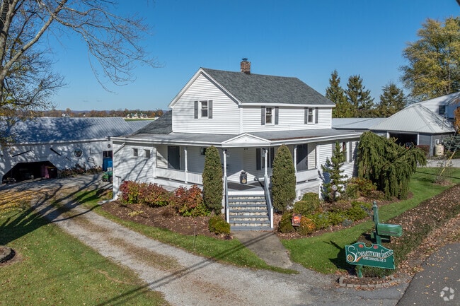

This Property Is For Sale
Property Detail
1 County Route 1 Cir
335489-012-000-0004-061.000-0000
ORANGE
Truckcrops
New York
00115
60.00
B and X Area of moderate flood hazard, usually the area between the limits of the 100-year and 500-year floods.
3 AC
2024
Monroe
2024
Northern New Jersey
014501
Kiryas Joel-Poughkeepsie-Newburgh, NY
NEARBY LISTINGS FOR SALE OR LEASE
-
-
View all Warwick listings for sale on LoopNet.com
DEMOGRAPHICS near 1 County Route 1 Cir
1 mile
3 mile
5 mile
2025 Total Population
1,140
5,023
16,696
2030 Population
1,165
5,137
16,962
Pop Growth 2025-2030
+ 2.19%
+ 2.27%
+ 1.59%
Average Age
42
43
43
2025 Total Households
400
1,790
6,081
HH Growth 2025-2030
+ 2.25%
+ 2.35%
+ 1.63%
Median Household Inc
$131,510
$137,231
$123,335
Avg Household Size
2.80
2.80
2.70
2025 Avg HH Vehicles
3.00
2.00
2.00
Median Home Value
$547,143
$600,388
$479,578
Median Year Built
1972
1977
1976
Nearby Places
Map Layers
Map Styles
 Street
 Aerial
Transit
 Traffic
 Biking
Places
Listings with unknown addresses are not visible on the map
- Restaurants
- Banks
- Shops
- Fitness
- Groceries
PUBLIC TRANSPORTATION
AIRPORT
New York Stewart International
Drive
Walk
Distance
New York Stewart International
53 min
29.5 mi
Freight Ports
Port Newark Container Terminal
Drive
Walk
Distance
Port Newark Container Terminal
89 min
58.2 mi
Nearby Properties
Address
Land Use
TOTAL SIZE
Lot Size
Zoning
Address
Land Use
TOTAL SIZE
Lot Size
Zoning
5,880 SF
260.40 AC
CONF
Address
Land Use
TOTAL SIZE
Lot Size
Zoning
50 AC
R1
Address
Land Use
TOTAL SIZE
Lot Size
Zoning
1,428 SF
1 AC
Address
Land Use
TOTAL SIZE
Lot Size
Zoning
14,710 SF
2.10 AC
00415
Address
Land Use
TOTAL SIZE
Lot Size
Zoning
198.50 AC
AP
Address
Land Use
TOTAL SIZE
Lot Size
Zoning
169.80 AC
AP
Address
Land Use
TOTAL SIZE
Lot Size
Zoning
13,369 SF
43.70 AC
00220
Address
Land Use
TOTAL SIZE
Lot Size
Zoning
4,311 SF
52.20 AC
00220
Address
Land Use
TOTAL SIZE
Lot Size
Zoning
155 AC
AP
Address
Land Use
TOTAL SIZE
Lot Size
Zoning
3,392 SF
132.10 AC
AR
Address
Land Use
TOTAL SIZE
Lot Size
Zoning
3,369 SF
145.10 AC
00220
Address
Land Use
TOTAL SIZE
Lot Size
Zoning
8,729 SF
76.60 AC
00220
Address
Land Use
TOTAL SIZE
Lot Size
Zoning
6,989 SF
27.80 AC
00220
Address
Land Use
TOTAL SIZE
Lot Size
Zoning
132.90 AC
AP
Address
Land Use
TOTAL SIZE
Lot Size
Zoning
4,557 SF
201.30 AC
00240
Address
Land Use
TOTAL SIZE
Lot Size
Zoning
8,556 SF
0.41 AC
00205
Address
Land Use
TOTAL SIZE
Lot Size
Zoning
4,438 SF
194.10 AC
00220
Address
Land Use
TOTAL SIZE
Lot Size
Zoning
37,482 SF
5.80 AC
00115
Address
Land Use
TOTAL SIZE
Lot Size
Zoning
3,365 SF
95.90 AC
00220
Address
Land Use
TOTAL SIZE
Lot Size
Zoning
2,107 SF
44 AC
00115
Address
Land Use
TOTAL SIZE
Lot Size
Zoning
1,395 SF
98.80 AC
00220
Address
Land Use
TOTAL SIZE
Lot Size
Zoning
49,942 SF
300.30 AC
00115
Address
Land Use
TOTAL SIZE
Lot Size
Zoning
5,326 SF
62.30 AC
00220
Address
Land Use
TOTAL SIZE
Lot Size
Zoning
2,960 SF
161.70 AC
00220
Address
Land Use
TOTAL SIZE
Lot Size
Zoning
32.80 AC
00215
Address
Land Use
TOTAL SIZE
Lot Size
Zoning
10,998 SF
11.40 AC
00215
Address
Land Use
TOTAL SIZE
Lot Size
Zoning
6,300 SF
1.90 AC
00415
Address
Land Use
TOTAL SIZE
Lot Size
Zoning
14,864 SF
0.70 AC
00415
Address
Land Use
TOTAL SIZE
Lot Size
Zoning
19,124 SF
14.20 AC
00720
Address
Land Use
TOTAL SIZE
Lot Size
Zoning
37,910 SF
6.40 AC
00415
The World's #1 Commercial Real Estate Marketplace
Connect with us
© 2026 CoStar Group
The information above has been obtained from sources believed reliable. While we do not doubt its accuracy we have not verified it and make no guarantee, warranty or representation about it. It is your responsibility to independently confirm its accuracy and completeness. Any projections, opinions, assumptions, or estimates used are for example only and do not represent the current or future performance of the property. The value of this transaction to you depends on tax and other factors which should be evaluated by your tax, financial, and legal advisors. You and your advisors should conduct a careful, independent investigation of the property to determine to your satisfaction the suitability of the property for your needs.