Property Record
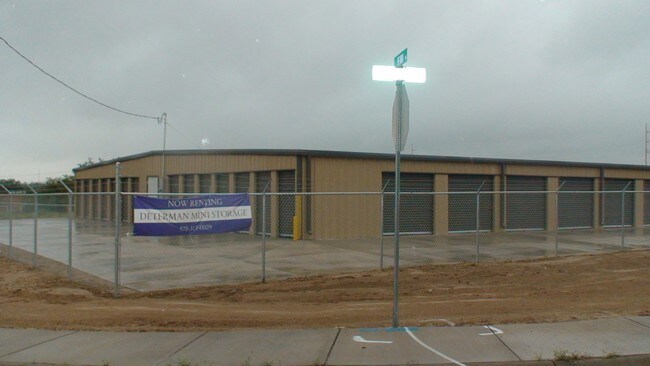
2 Determan Ln, Roswell, NM 88201


Property Detail
2 Determan Ln
R005124
Franklin Determan Industrial Park
Realpropertynec
SUBD: FRANKLIN DETERMAN INDUSTRIAL PARK SUBDIVISION TRACT: C QUARTER: NW S: 33 T: 10S R: 24E DOC# 202208693 WD
AO
Chaves
35005C1370D
New Mexico
2024
7.82 AC
2025
Other Market Areas
001002
Roswell, NM
6,400 SF
NEARBY LISTINGS FOR SALE OR LEASE
-
-
View all Roswell listings for sale on LoopNet.com
DEMOGRAPHICS near 2 Determan Ln
1 mile
3 mile
5 mile
2024 Total Population
6,113
40,790
50,541
2029 Population
6,037
40,211
49,848
Pop Growth 2024-2029
(1.24%)
(1.42%)
(1.37%)
Average Age
37
38
38
2024 Total Households
2,350
15,377
18,949
HH Growth 2024-2029
(1.32%)
(1.53%)
(1.47%)
Median Household Inc
$37,794
$47,560
$48,613
Avg Household Size
2.40
2.60
2.60
2024 Avg HH Vehicles
2.00
2.00
2.00
Median Home Value
$97,179
$143,539
$142,878
Median Year Built
1963
1968
1969
Nearby Places
Map Layers
Map Styles
 Street
 Aerial
Transit
 Traffic
 Biking
Places
Listings with unknown addresses are not visible on the map
- Restaurants
- Banks
- Shops
- Fitness
- Groceries
PUBLIC TRANSPORTATION
AIRPORT
Roswell Air Center
Drive
Walk
Distance
Roswell Air Center
18 min
8.1 mi
SALE & LEASE HISTORY
LISTING DATE
SALE/LEASE

Nov 04, 2016
For Sale
Apr 13, 2018
For Sale
Nearby Properties
Address
Land Use
TOTAL SIZE
Lot Size
Zoning
Address
Land Use
TOTAL SIZE
Lot Size
Zoning
1,829,640 SF
3.68 AC
CENTRAL BU
Address
Land Use
TOTAL SIZE
Lot Size
Zoning
10,644 SF
5.81 AC
COMMUNITY
Address
Land Use
TOTAL SIZE
Lot Size
Zoning
42.76 AC
RESIDENTIA
Address
Land Use
TOTAL SIZE
Lot Size
Zoning
23.93 AC
RESIDENTIA
Address
Land Use
TOTAL SIZE
Lot Size
Zoning
18.18 AC
COMMUNITY
Address
Land Use
TOTAL SIZE
Lot Size
Zoning
230,872 SF
9.40 AC
COMMUNITY
Address
Land Use
TOTAL SIZE
Lot Size
Zoning
10 AC
RESIDENTIA
Address
Land Use
TOTAL SIZE
Lot Size
Zoning
2.54 AC
RESIDENTIA
Address
Land Use
TOTAL SIZE
Lot Size
Zoning
2.58 AC
COMMUNITY
Address
Land Use
TOTAL SIZE
Lot Size
Zoning
150.96 AC
RESIDENTIA
Address
Land Use
TOTAL SIZE
Lot Size
Zoning
1.59 AC
CENTRAL BU
Address
Land Use
TOTAL SIZE
Lot Size
Zoning
56.23 AC
Address
Land Use
TOTAL SIZE
Lot Size
Zoning
11.02 AC
RESIDENTIA
Address
Land Use
TOTAL SIZE
Lot Size
Zoning
18,630 SF
9.10 AC
COMMUNITY
Address
Land Use
TOTAL SIZE
Lot Size
Zoning
17,567 SF
1.24 AC
RESIDENTIA
Address
Land Use
TOTAL SIZE
Lot Size
Zoning
6.47 AC
RESIDENTIA
Address
Land Use
TOTAL SIZE
Lot Size
Zoning
2.36 AC
RESIDENTIA
Address
Land Use
TOTAL SIZE
Lot Size
Zoning
9.52 AC
RESIDENTIA
Address
Land Use
TOTAL SIZE
Lot Size
Zoning
3.58 AC
RESIDENTIA
Address
Land Use
TOTAL SIZE
Lot Size
Zoning
2.10 AC
CENTRAL BU
Address
Land Use
TOTAL SIZE
Lot Size
Zoning
5 AC
RESIDENTIA
Address
Land Use
TOTAL SIZE
Lot Size
Zoning
Address
Land Use
TOTAL SIZE
Lot Size
Zoning
134,448 SF
15.85 AC
COMMUNITY
Address
Land Use
TOTAL SIZE
Lot Size
Zoning
4.91 AC
RESIDENTIA
Address
Land Use
TOTAL SIZE
Lot Size
Zoning
38,671 SF
6.59 AC
COMMUNITY
Address
Land Use
TOTAL SIZE
Lot Size
Zoning
21,500 SF
4.78 AC
COMMUNITY
Address
Land Use
TOTAL SIZE
Lot Size
Zoning
2.61 AC
RESIDENTIA
Address
Land Use
TOTAL SIZE
Lot Size
Zoning
44,153 SF
1.29 AC
CENTRAL BU
Address
Land Use
TOTAL SIZE
Lot Size
Zoning
20.23 AC
RESIDENTIA
Address
Land Use
TOTAL SIZE
Lot Size
Zoning
39,382 SF
1.90 AC
COMMUNITY
The World's #1 Commercial Real Estate Marketplace
Connect with us
© 2026 CoStar Group
The information above has been obtained from sources believed reliable. While we do not doubt its accuracy we have not verified it and make no guarantee, warranty or representation about it. It is your responsibility to independently confirm its accuracy and completeness. Any projections, opinions, assumptions, or estimates used are for example only and do not represent the current or future performance of the property. The value of this transaction to you depends on tax and other factors which should be evaluated by your tax, financial, and legal advisors. You and your advisors should conduct a careful, independent investigation of the property to determine to your satisfaction the suitability of the property for your needs.