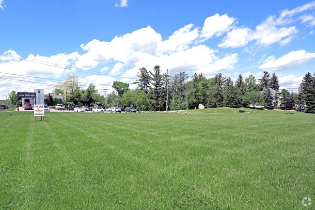
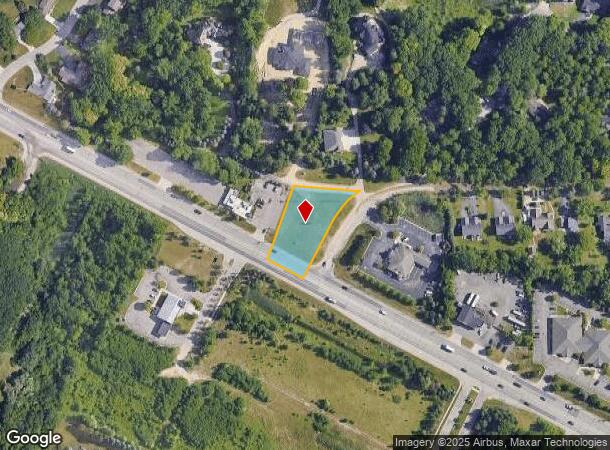
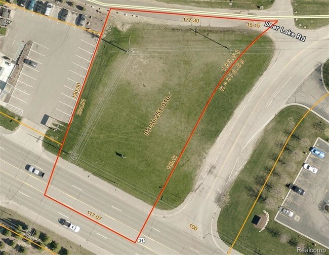
Property Record
7450 Dixie Hwy, Clarkston, MI 48346
NEARBY LISTINGS FOR SALE OR LEASE
Property Detail
7450 Dixie Hwy
08-30-251-010
T4N, R9E, SEC 30 PART OF NE 1/4 BEG AT PT DIST S 00-15-48 E 2673.58 FT & N 60-31-30 W 255.23 FT & N 60-28-00 W 1016.15 FT & N
Commercialnec
Oakland
X
Michigan
26125C0331F
0.82 AC
2024
Lakes Area
2025
Detroit
127500
Detroit-Warren-Dearborn, MI
DEMOGRAPHICS near 7450 Dixie Hwy
1 Mile
3 Mile
5 Mile
2024 Total Population
3,797
27,249
64,104
2029 Population
3,807
26,957
63,418
Pop Growth 2024-2029
+ 0.26%
(1.07%)
(1.07%)
Average Age
45
43
43
2024 Total Households
1,470
10,771
25,351
HH Growth 2024-2029
+ 0.07%
(1.15%)
(1.16%)
Median Household Inc
$120,767
$96,796
$94,336
Avg Household Size
2.50
2.50
2.50
2024 Avg HH Vehicles
2.00
2.00
2.00
Median Home Value
$366,759
$313,730
$302,461
Median Year Built
1982
1978
1977
Nearby Places
Map Layers
Map Styles
 Street
 Aerial
- Restaurants
- Banks
- Shops
- Fitness
- Groceries
PUBLIC TRANSPORTATION
AIRPORT
Bishop International
DRIVE
WALK
Distance
Bishop International
40 min
26.7 mi
Freight Ports
Port of Toledo
DRIVE
WALK
Distance
Port of Toledo
110 min
85.5 mi
SALE & LEASE HISTORY
LISTING DATE
SALE/LEASE

Sep 24, 2016
For Sale
Jul 06, 2017
For Sale
Nearby Properties
Address
Land Use
TOTAL SIZE
Lot Size
Zoning
Address
Land Use
TOTAL SIZE
Lot Size
Zoning
1,075,040 SF
90.26 AC
II
Address
Land Use
TOTAL SIZE
Lot Size
Zoning
17.63 AC
R3
Address
Land Use
TOTAL SIZE
Lot Size
Zoning
208,006 SF
1.24 AC
R2
Address
Land Use
TOTAL SIZE
Lot Size
Zoning
68,725 SF
4.96 AC
PUD
Address
Land Use
TOTAL SIZE
Lot Size
Zoning
21,719 SF
26.34 AC
R2
Address
Land Use
TOTAL SIZE
Lot Size
Zoning
249,200 SF
48.39 AC
R2
Address
Land Use
TOTAL SIZE
Lot Size
Zoning
327,288 SF
19.85 AC
R2
Address
Land Use
TOTAL SIZE
Lot Size
Zoning
78,261 SF
7.80 AC
PUD
Address
Land Use
TOTAL SIZE
Lot Size
Zoning
7.18 AC
PUD
Address
Land Use
TOTAL SIZE
Lot Size
Zoning
44.10 AC
PUD
Address
Land Use
TOTAL SIZE
Lot Size
Zoning
87,130 SF
9.01 AC
C-3
Address
Land Use
TOTAL SIZE
Lot Size
Zoning
327,288 SF
29.09 AC
REC
Address
Land Use
TOTAL SIZE
Lot Size
Zoning
19,504 SF
3.16 AC
ML
Address
Land Use
TOTAL SIZE
Lot Size
Zoning
151,736 SF
26.03 AC
C-2
Address
Land Use
TOTAL SIZE
Lot Size
Zoning
111,760 SF
29.33 AC
R2
Address
Land Use
TOTAL SIZE
Lot Size
Zoning
48,645 SF
6.68 AC
PUD
Address
Land Use
TOTAL SIZE
Lot Size
Zoning
49,169 SF
5.02 AC
PUD
Address
Land Use
TOTAL SIZE
Lot Size
Zoning
44,915 SF
0.47 AC
PUD
Address
Land Use
TOTAL SIZE
Lot Size
Zoning
32,059 SF
BLL
Address
Land Use
TOTAL SIZE
Lot Size
Zoning
143,550 SF
11.92 AC
R2
Address
Land Use
TOTAL SIZE
Lot Size
Zoning
739 SF
5.36 AC
R1A
Address
Land Use
TOTAL SIZE
Lot Size
Zoning
62,944 SF
6.65 AC
C-2
Address
Land Use
TOTAL SIZE
Lot Size
Zoning
116,816 SF
12.75 AC
R2
Address
Land Use
TOTAL SIZE
Lot Size
Zoning
82,864 SF
30.65 AC
MH
Address
Land Use
TOTAL SIZE
Lot Size
Zoning
34,111 SF
20.14 AC
Address
Land Use
TOTAL SIZE
Lot Size
Zoning
70,140 SF
6.67 AC
BI
Address
Land Use
TOTAL SIZE
Lot Size
Zoning
34,807 SF
3.34 AC
OS-2
Address
Land Use
TOTAL SIZE
Lot Size
Zoning
30,726 SF
3.44 AC
R3
Address
Land Use
TOTAL SIZE
Lot Size
Zoning
2,220 SF
80 AC
REC
Address
Land Use
TOTAL SIZE
Lot Size
Zoning
80,974 SF
8.37 AC
C-3
The World's #1 Commercial Real Estate Marketplace
Connect with us
© 2025 CoStar Group
The information above has been obtained from sources believed reliable. While we do not doubt its accuracy we have not verified it and make no guarantee, warranty or representation about it. It is your responsibility to independently confirm its accuracy and completeness. Any projections, opinions, assumptions, or estimates used are for example only and do not represent the current or future performance of the property. The value of this transaction to you depends on tax and other factors which should be evaluated by your tax, financial, and legal advisors. You and your advisors should conduct a careful, independent investigation of the property to determine to your satisfaction the suitability of the property for your needs.