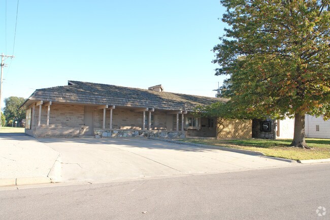
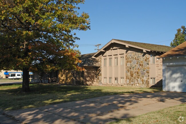
Property Record
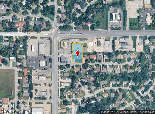
1 E 30Th Ave, Hutchinson, KS 67502
NEARBY LISTINGS FOR SALE OR LEASE
Property Detail
1 E 30Th Ave
121-01-0-10-03-007.01
Tracts
Officebuilding
TRACTS, S01, T23, R06W, TR COM AT NW COR NE/4 TH S 112FT FOR POB TH CONT S 223FT TH E 137FT TH N 223FT TH W 137FT TO POB
X
Reno
20155C0283G
Kansas
2024
0.70 AC
2024
Kansas Area
000300
Other Market Areas
3,783 SF
Hutchinson, KS
DEMOGRAPHICS near 1 E 30Th Ave
1 Mile
3 Mile
5 Mile
2024 Total Population
7,683
37,291
45,522
2029 Population
7,572
37,167
45,333
Pop Growth 2024-2029
(1.44%)
(0.33%)
(0.42%)
Average Age
44
41
42
2024 Total Households
3,341
15,985
19,367
HH Growth 2024-2029
(1.47%)
(0.36%)
(0.45%)
Median Household Inc
$60,548
$51,988
$52,113
Avg Household Size
2.20
2.20
2.20
2024 Avg HH Vehicles
2.00
2.00
2.00
Median Home Value
$145,092
$109,599
$116,507
Median Year Built
1962
1958
1961
Nearby Places
Map Layers
Map Styles
 Street
 Aerial
- Restaurants
- Banks
- Shops
- Fitness
- Groceries
SALE & LEASE HISTORY
LISTING DATE
SALE/LEASE

May 05, 2017
For Lease
Nearby Properties
Address
Land Use
TOTAL SIZE
Lot Size
Zoning
Address
Land Use
TOTAL SIZE
Lot Size
Zoning
19,260 SF
11 AC
P
Address
Land Use
TOTAL SIZE
Lot Size
Zoning
89,458 SF
1.88 AC
P
Address
Land Use
TOTAL SIZE
Lot Size
Zoning
2,502 SF
44.42 AC
P
Address
Land Use
TOTAL SIZE
Lot Size
Zoning
3,120 SF
36.34 AC
PI
Address
Land Use
TOTAL SIZE
Lot Size
Zoning
2,400 SF
18 AC
Address
Land Use
TOTAL SIZE
Lot Size
Zoning
20,582 SF
8.85 AC
R5
Address
Land Use
TOTAL SIZE
Lot Size
Zoning
1,728 SF
10.68 AC
P
Address
Land Use
TOTAL SIZE
Lot Size
Zoning
59.65 AC
P
Address
Land Use
TOTAL SIZE
Lot Size
Zoning
54,149 SF
9.27 AC
Address
Land Use
TOTAL SIZE
Lot Size
Zoning
42,659 SF
4.58 AC
P
Address
Land Use
TOTAL SIZE
Lot Size
Zoning
121,446 SF
14.69 AC
PI
Address
Land Use
TOTAL SIZE
Lot Size
Zoning
143 SF
110.23 AC
P
Address
Land Use
TOTAL SIZE
Lot Size
Zoning
4,000 SF
19.83 AC
C1
Address
Land Use
TOTAL SIZE
Lot Size
Zoning
64,700 SF
5.73 AC
C4
Address
Land Use
TOTAL SIZE
Lot Size
Zoning
29,431 SF
1.50 AC
C5
Address
Land Use
TOTAL SIZE
Lot Size
Zoning
64,802 SF
14.07 AC
P
Address
Land Use
TOTAL SIZE
Lot Size
Zoning
43,928 SF
4.99 AC
R5
Address
Land Use
TOTAL SIZE
Lot Size
Zoning
1,320 SF
5.94 AC
Address
Land Use
TOTAL SIZE
Lot Size
Zoning
3,648 SF
15.60 AC
CR
Address
Land Use
TOTAL SIZE
Lot Size
Zoning
101,932 SF
1.50 AC
P
Address
Land Use
TOTAL SIZE
Lot Size
Zoning
89,591 SF
3.31 AC
P
Address
Land Use
TOTAL SIZE
Lot Size
Zoning
840 SF
17.62 AC
P
Address
Land Use
TOTAL SIZE
Lot Size
Zoning
3,064 SF
3.46 AC
Address
Land Use
TOTAL SIZE
Lot Size
Zoning
3,240 SF
13.17 AC
P
Address
Land Use
TOTAL SIZE
Lot Size
Zoning
59,962 SF
2.52 AC
P
Address
Land Use
TOTAL SIZE
Lot Size
Zoning
16,116 SF
1.37 AC
C1
Address
Land Use
TOTAL SIZE
Lot Size
Zoning
65,156 SF
8.10 AC
P
Address
Land Use
TOTAL SIZE
Lot Size
Zoning
196,881 SF
27.83 AC
C4
Address
Land Use
TOTAL SIZE
Lot Size
Zoning
56,680 SF
14.06 AC
Address
Land Use
TOTAL SIZE
Lot Size
Zoning
33,881 SF
6.23 AC
The World's #1 Commercial Real Estate Marketplace
Connect with us
© 2025 CoStar Group
The information above has been obtained from sources believed reliable. While we do not doubt its accuracy we have not verified it and make no guarantee, warranty or representation about it. It is your responsibility to independently confirm its accuracy and completeness. Any projections, opinions, assumptions, or estimates used are for example only and do not represent the current or future performance of the property. The value of this transaction to you depends on tax and other factors which should be evaluated by your tax, financial, and legal advisors. You and your advisors should conduct a careful, independent investigation of the property to determine to your satisfaction the suitability of the property for your needs.