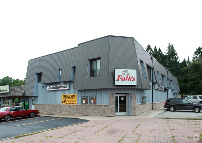
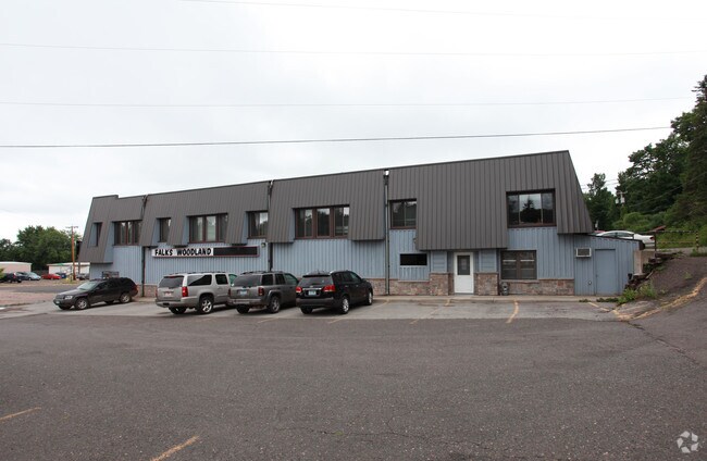
Property Record
1 E Calvary Rd, Duluth, MN 55803

Property Detail
1 E Calvary Rd
010066000010
EX THAT PART DESCRIBED AS FOLLOWS BEG ATSW CORNER RUNNING THENCE N AT RT ANGLES164.67 FT THENCE WLY 27.49 FT TO NWCORNER THENCE SLY 168.65 FT TO POINT OFBEGINING AND ALL OF OUTLOT A & INC PART OFVAC CALVARY RD ADJ & INC PART OF VAC WOODLAND SERIAL #
Apartment
Saint Louis
C1
Minnesota
B and X Area of moderate flood hazard, usually the area between the limits of the 100-year and 500-year floods.
19
2025
0.13 AC
2024
North Duluth
000100
Duluth
12,028 SF
Duluth, MN-WI
NEARBY LISTINGS FOR SALE OR LEASE
-
-
View all Duluth listings for lease on LoopNet.com
DEMOGRAPHICS near 1 E Calvary Rd
1 mile
3 mile
5 mile
2025 Total Population
3,750
28,667
55,711
2030 Population
3,668
28,236
54,914
Pop Growth 2025-2030
(2.19%)
(1.50%)
(1.43%)
Average Age
40
38
38
2025 Total Households
1,476
10,250
22,636
HH Growth 2025-2030
(2.24%)
(1.78%)
(1.67%)
Median Household Inc
$100,504
$96,114
$69,173
Avg Household Size
2.40
2.40
2.10
2025 Avg HH Vehicles
2.00
2.00
2.00
Median Home Value
$276,542
$302,697
$292,090
Median Year Built
1954
1954
1954
Nearby Places
Map Layers
Map Styles
 Street
 Aerial
Transit
 Traffic
 Biking
Places
Listings with unknown addresses are not visible on the map
- Restaurants
- Banks
- Shops
- Fitness
- Groceries
PUBLIC TRANSPORTATION
AIRPORT
Duluth International
Drive
Walk
Distance
Duluth International
18 min
9.8 mi
Freight Ports
Port of Baltimore
Drive
Walk
Distance
Port of Baltimore
1 min
938.7 mi
SALE & LEASE HISTORY
LISTING DATE
SALE/LEASE

Sep 25, 2016
For Lease
Nearby Properties
Address
Land Use
TOTAL SIZE
Lot Size
Zoning
Address
Land Use
TOTAL SIZE
Lot Size
Zoning
210,288 SF
146 AC
Address
Land Use
TOTAL SIZE
Lot Size
Zoning
299,603 SF
27.91 AC
Address
Land Use
TOTAL SIZE
Lot Size
Zoning
143,370 SF
8.69 AC
Address
Land Use
TOTAL SIZE
Lot Size
Zoning
143,132 SF
41.55 AC
Address
Land Use
TOTAL SIZE
Lot Size
Zoning
6,500 SF
3.31 AC
R3
Address
Land Use
TOTAL SIZE
Lot Size
Zoning
132,316 SF
2.13 AC
Address
Land Use
TOTAL SIZE
Lot Size
Zoning
164,700 SF
2.69 AC
R4
Address
Land Use
TOTAL SIZE
Lot Size
Zoning
126,349 SF
8.35 AC
Address
Land Use
TOTAL SIZE
Lot Size
Zoning
82,119 SF
5.21 AC
Address
Land Use
TOTAL SIZE
Lot Size
Zoning
91,053 SF
0.60 AC
Address
Land Use
TOTAL SIZE
Lot Size
Zoning
77,816 SF
4.43 AC
Address
Land Use
TOTAL SIZE
Lot Size
Zoning
140,999 SF
1.57 AC
Address
Land Use
TOTAL SIZE
Lot Size
Zoning
177,479 SF
1.69 AC
Address
Land Use
TOTAL SIZE
Lot Size
Zoning
97,573 SF
4.26 AC
R3
Address
Land Use
TOTAL SIZE
Lot Size
Zoning
91,980 SF
0.58 AC
R4
Address
Land Use
TOTAL SIZE
Lot Size
Zoning
39,615 SF
1.73 AC
Address
Land Use
TOTAL SIZE
Lot Size
Zoning
61,088 SF
4.58 AC
R4
Address
Land Use
TOTAL SIZE
Lot Size
Zoning
158,388 SF
6.21 AC
Address
Land Use
TOTAL SIZE
Lot Size
Zoning
81,456 SF
78.03 AC
Address
Land Use
TOTAL SIZE
Lot Size
Zoning
177,479 SF
0.77 AC
Address
Land Use
TOTAL SIZE
Lot Size
Zoning
19,127 SF
9.48 AC
Address
Land Use
TOTAL SIZE
Lot Size
Zoning
58,756 SF
126.18 AC
Address
Land Use
TOTAL SIZE
Lot Size
Zoning
61,088 SF
0.32 AC
Address
Land Use
TOTAL SIZE
Lot Size
Zoning
28,764 SF
0.11 AC
Address
Land Use
TOTAL SIZE
Lot Size
Zoning
29,274 SF
0.28 AC
Address
Land Use
TOTAL SIZE
Lot Size
Zoning
8.86 AC
Address
Land Use
TOTAL SIZE
Lot Size
Zoning
50,322 SF
1.60 AC
R4
Address
Land Use
TOTAL SIZE
Lot Size
Zoning
61,980 SF
2.43 AC
R3
Address
Land Use
TOTAL SIZE
Lot Size
Zoning
45,290 SF
3.07 AC
The World's #1 Commercial Real Estate Marketplace
Connect with us
© 2026 CoStar Group
The information above has been obtained from sources believed reliable. While we do not doubt its accuracy we have not verified it and make no guarantee, warranty or representation about it. It is your responsibility to independently confirm its accuracy and completeness. Any projections, opinions, assumptions, or estimates used are for example only and do not represent the current or future performance of the property. The value of this transaction to you depends on tax and other factors which should be evaluated by your tax, financial, and legal advisors. You and your advisors should conduct a careful, independent investigation of the property to determine to your satisfaction the suitability of the property for your needs.