Property Record
1 E High St, Metamora, MI 48455
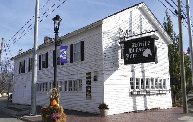

Property Detail
1 E High St
045-509-051-00
15 56 000 000 00 SEC 9 T6N R10E VILLAGE OF METAMORA COM ON E LN OF TERRITORIAL RD [AKA OAK ST] AT NORTH LINE OF HWY M-181
Restaurantbuilding
Lapeer
COMMERCIAL
Michigan
B and X Area of moderate flood hazard, usually the area between the limits of the 100-year and 500-year floods.
0.79 AC
2024
St Clair & Lapeer Counties
2025
Detroit
341500
Detroit-Warren-Dearborn, MI
10,892 SF
NEARBY LISTINGS FOR SALE OR LEASE
DEMOGRAPHICS near 1 E High St
1 mile
3 mile
5 mile
2025 Total Population
1,153
4,016
9,869
2030 Population
1,175
4,097
10,006
Pop Growth 2025-2030
+ 1.91%
+ 2.02%
+ 1.39%
Average Age
43
45
45
2025 Total Households
423
1,573
3,781
HH Growth 2025-2030
+ 1.89%
+ 1.97%
+ 1.38%
Median Household Inc
$111,363
$95,364
$97,035
Avg Household Size
2.70
2.50
2.60
2025 Avg HH Vehicles
2.00
2.00
2.00
Median Home Value
$368,181
$346,069
$353,035
Median Year Built
1985
1981
1980
Nearby Places
Map Layers
Map Styles
 Street
 Aerial
Layers
 Traffic
 Biking
Places
Listings with unknown addresses are not visible on the map
- Restaurants
- Banks
- Shops
- Fitness
- Groceries
PUBLIC TRANSPORTATION
COMMUTER RAIL
Lapeer Amtrak Station (Blue Water - Amtrak)
Drive
Walk
Distance
Lapeer Amtrak Station (Blue Water - Amtrak)
16 min
9.5 mi
AIRPORT
Bishop International
Drive
Walk
Distance
Bishop International
50 min
34.4 mi
Freight Ports
Port of Toledo
Drive
Walk
Distance
Port of Toledo
141 min
111.0 mi
Nearby Properties
Address
Land Use
TOTAL SIZE
Lot Size
Zoning
Address
Land Use
TOTAL SIZE
Lot Size
Zoning
240 AC
RC
Address
Land Use
TOTAL SIZE
Lot Size
Zoning
147,978 SF
6.87 AC
INDUSTRIAL
Address
Land Use
TOTAL SIZE
Lot Size
Zoning
160 AC
RC
Address
Land Use
TOTAL SIZE
Lot Size
Zoning
208.46 AC
A-2
Address
Land Use
TOTAL SIZE
Lot Size
Zoning
576 SF
24.63 AC
MH
Address
Land Use
TOTAL SIZE
Lot Size
Zoning
220.81 AC
A-2
Address
Land Use
TOTAL SIZE
Lot Size
Zoning
6,962 SF
395 AC
AE
Address
Land Use
TOTAL SIZE
Lot Size
Zoning
80,800 SF
5.32 AC
M-1
Address
Land Use
TOTAL SIZE
Lot Size
Zoning
83 AC
A-2
Address
Land Use
TOTAL SIZE
Lot Size
Zoning
16,680 SF
10.95 AC
B-2
Address
Land Use
TOTAL SIZE
Lot Size
Zoning
2,461 SF
100.21 AC
A-2
Address
Land Use
TOTAL SIZE
Lot Size
Zoning
121.60 AC
A-2
Address
Land Use
TOTAL SIZE
Lot Size
Zoning
71.64 AC
A-2
Address
Land Use
TOTAL SIZE
Lot Size
Zoning
6,782 SF
31.97 AC
A-2
Address
Land Use
TOTAL SIZE
Lot Size
Zoning
208 AC
R-1
Address
Land Use
TOTAL SIZE
Lot Size
Zoning
228.30 AC
R-1
Address
Land Use
TOTAL SIZE
Lot Size
Zoning
80 AC
A-2
Address
Land Use
TOTAL SIZE
Lot Size
Zoning
11,180 SF
2.05 AC
B-2
Address
Land Use
TOTAL SIZE
Lot Size
Zoning
5,305 SF
2.27 AC
B-2
Address
Land Use
TOTAL SIZE
Lot Size
Zoning
183.40 AC
A-2
Address
Land Use
TOTAL SIZE
Lot Size
Zoning
45.96 AC
R-1
Address
Land Use
TOTAL SIZE
Lot Size
Zoning
102.31 AC
A-2
Address
Land Use
TOTAL SIZE
Lot Size
Zoning
177.92 AC
R-1
Address
Land Use
TOTAL SIZE
Lot Size
Zoning
995 SF
156.21 AC
A-1
Address
Land Use
TOTAL SIZE
Lot Size
Zoning
19,740 SF
3.01 AC
B-2
Address
Land Use
TOTAL SIZE
Lot Size
Zoning
10,558 SF
7.48 AC
B-2
Address
Land Use
TOTAL SIZE
Lot Size
Zoning
3,168 SF
1.43 AC
B-2
Address
Land Use
TOTAL SIZE
Lot Size
Zoning
1,990 SF
2.20 AC
B-2
Address
Land Use
TOTAL SIZE
Lot Size
Zoning
1,720 SF
51.45 AC
A-2
The World's #1 Commercial Real Estate Marketplace
Connect with us
© 2026 CoStar Group
The information above has been obtained from sources believed reliable. While we do not doubt its accuracy we have not verified it and make no guarantee, warranty or representation about it. It is your responsibility to independently confirm its accuracy and completeness. Any projections, opinions, assumptions, or estimates used are for example only and do not represent the current or future performance of the property. The value of this transaction to you depends on tax and other factors which should be evaluated by your tax, financial, and legal advisors. You and your advisors should conduct a careful, independent investigation of the property to determine to your satisfaction the suitability of the property for your needs.