Property Record
1 E Main St, Riverhead, NY 11901


Save to a Folder
{{folder.Name}}
{{folder.ListingIds.length}} Properties
{{folder.ListingIds.length}} Property
Create a New Folder
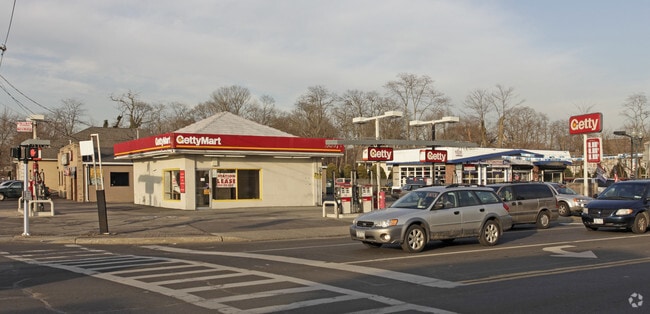
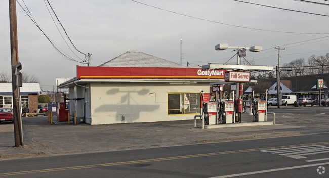
This Property Is For Sale
Property Detail
1 E Main St
Nassau County-Suffolk County, NY
X2224205Y185311 N060N00000000
0500-372-00-02-00-041-000
Suffolk
Servicestation
New York
BUS1
200
B and X Area of moderate flood hazard, usually the area between the limits of the 100-year and 500-year floods.
0.19 AC
0
Southwestern Suffolk
2025
Long Island (New York)
134908
NEARBY LISTINGS FOR SALE OR LEASE
DEMOGRAPHICS near 1 E Main St
1 mile
3 mile
5 mile
2025 Total Population
12,551
64,342
175,756
2030 Population
12,483
63,510
172,405
Pop Growth 2025-2030
(0.54%)
(1.29%)
(1.91%)
Average Age
42
41
40
2025 Total Households
4,368
21,360
52,726
HH Growth 2025-2030
(0.85%)
(1.25%)
(1.78%)
Median Household Inc
$144,635
$124,697
$118,464
Avg Household Size
2.80
2.90
3.10
2025 Avg HH Vehicles
2.00
2.00
2.00
Median Home Value
$681,169
$595,737
$518,539
Median Year Built
1959
1965
1965
Nearby Places
Map Layers
Map Styles
 Street
 Aerial
Layers
 Traffic
 Biking
Places
Listings with unknown addresses are not visible on the map
- Restaurants
- Banks
- Shops
- Fitness
- Groceries
PUBLIC TRANSPORTATION
TRANSIT/SUBWAY
Riverhead Station (Greenport Branch - Long Island Rail Road)
Drive
Walk
Distance
Riverhead Station (Greenport Branch - Long Island Rail Road)
1 min
8 min
0.4 mi
COMMUTER RAIL
Riverhead Station (Greenport Branch - Long Island Rail Road)
Drive
Walk
Distance
Riverhead Station (Greenport Branch - Long Island Rail Road)
1 min
8 min
0.4 mi
Westhampton Station (Montauk Branch - Long Island Rail Road)
Drive
Walk
Distance
Westhampton Station (Montauk Branch - Long Island Rail Road)
11 min
6.6 mi
AIRPORT
Long Island MacArthur
Drive
Walk
Distance
Long Island MacArthur
42 min
27.6 mi
Freight Ports
Port of New Haven
Drive
Walk
Distance
Port of New Haven
148 min
60.1 mi
Nearby Properties
Address
Land Use
TOTAL SIZE
Lot Size
Zoning
Address
Land Use
TOTAL SIZE
Lot Size
Zoning
233,668 SF
82.70 AC
CR200
Address
Land Use
TOTAL SIZE
Lot Size
Zoning
450,000 SF
8.50 AC
3
Address
Land Use
TOTAL SIZE
Lot Size
Zoning
252,053 SF
31.60 AC
3
Address
Land Use
TOTAL SIZE
Lot Size
Zoning
42.70 AC
9
Address
Land Use
TOTAL SIZE
Lot Size
Zoning
49,680 SF
1.30 AC
8
Address
Land Use
TOTAL SIZE
Lot Size
Zoning
176,704 SF
34.70 AC
3
Address
Land Use
TOTAL SIZE
Lot Size
Zoning
51.70 AC
R15
Address
Land Use
TOTAL SIZE
Lot Size
Zoning
47.30 AC
9
Address
Land Use
TOTAL SIZE
Lot Size
Zoning
18,880 SF
213 AC
CR200
Address
Land Use
TOTAL SIZE
Lot Size
Zoning
8,100 SF
4.31 AC
LI40
Address
Land Use
TOTAL SIZE
Lot Size
Zoning
197.50 AC
Address
Land Use
TOTAL SIZE
Lot Size
Zoning
127,334 SF
49.72 AC
04
Address
Land Use
TOTAL SIZE
Lot Size
Zoning
17 AC
CR200
Address
Land Use
TOTAL SIZE
Lot Size
Zoning
151,290 SF
6.17 AC
08
Address
Land Use
TOTAL SIZE
Lot Size
Zoning
81.70 AC
R60
Address
Land Use
TOTAL SIZE
Lot Size
Zoning
36,883 SF
14.80 AC
R15
Address
Land Use
TOTAL SIZE
Lot Size
Zoning
23,743 SF
5.80 AC
MTL
Address
Land Use
TOTAL SIZE
Lot Size
Zoning
25,620 SF
7.03 AC
9
Address
Land Use
TOTAL SIZE
Lot Size
Zoning
13.92 AC
04
Address
Land Use
TOTAL SIZE
Lot Size
Zoning
16,699 SF
24.81 AC
03
Address
Land Use
TOTAL SIZE
Lot Size
Zoning
20.72 AC
09
Address
Land Use
TOTAL SIZE
Lot Size
Zoning
29.72 AC
R20
Address
Land Use
TOTAL SIZE
Lot Size
Zoning
68.90 AC
H2O
Address
Land Use
TOTAL SIZE
Lot Size
Zoning
31,462 SF
5.74 AC
LI200
Address
Land Use
TOTAL SIZE
Lot Size
Zoning
26.39 AC
04
Address
Land Use
TOTAL SIZE
Lot Size
Zoning
108,572 SF
17.30 AC
04
Address
Land Use
TOTAL SIZE
Lot Size
Zoning
108,504 SF
31.20 AC
SC
Address
Land Use
TOTAL SIZE
Lot Size
Zoning
3,468 SF
17.70 AC
CR60
Address
Land Use
TOTAL SIZE
Lot Size
Zoning
13,773 SF
11.65 AC
03
Address
Land Use
TOTAL SIZE
Lot Size
Zoning
36.60 AC
RC
The World's #1 Commercial Real Estate Marketplace
Connect with us
© 2026 CoStar Group
The information above has been obtained from sources believed reliable. While we do not doubt its accuracy we have not verified it and make no guarantee, warranty or representation about it. It is your responsibility to independently confirm its accuracy and completeness. Any projections, opinions, assumptions, or estimates used are for example only and do not represent the current or future performance of the property. The value of this transaction to you depends on tax and other factors which should be evaluated by your tax, financial, and legal advisors. You and your advisors should conduct a careful, independent investigation of the property to determine to your satisfaction the suitability of the property for your needs.