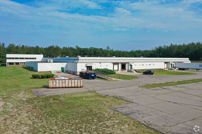
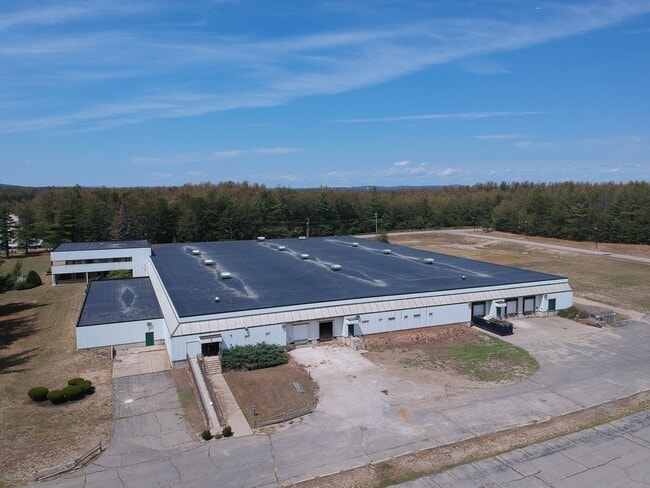
Property Record
1 Eagle Dr, Sanford, ME 04073

Current Lease Availabilities
Property Detail
1 Eagle Dr
Manufacturinglight
York
IB
Maine
B and X Area of moderate flood hazard, usually the area between the limits of the 100-year and 500-year floods.
12.56 AC
2025
York County
2025
Portland/South Portland
030300
Portland-South Portland, ME
95,901 SF
SANF-000002A-R000019
NEARBY LISTINGS FOR SALE OR LEASE
DEMOGRAPHICS near 1 Eagle Dr
1 mile
3 mile
5 mile
2025 Total Population
396
6,076
23,677
2030 Population
406
6,208
24,198
Pop Growth 2025-2030
+ 2.53%
+ 2.17%
+ 2.20%
Average Age
47
45
43
2025 Total Households
177
2,559
9,653
HH Growth 2025-2030
+ 2.82%
+ 2.11%
+ 2.13%
Median Household Inc
$71,911
$78,766
$74,989
Avg Household Size
2.20
2.30
2.40
2025 Avg HH Vehicles
2.00
2.00
2.00
Median Home Value
$277,026
$323,556
$332,396
Median Year Built
1984
1983
1977
Nearby Places
Map Layers
Map Styles
 Street
 Aerial
Layers
 Traffic
 Biking
Places
Listings with unknown addresses are not visible on the map
- Restaurants
- Banks
- Shops
- Fitness
- Groceries
PUBLIC TRANSPORTATION
COMMUTER RAIL
Drive
Walk
Distance
16 min
8.0 mi
AIRPORT
Portsmouth International at Pease
Drive
Walk
Distance
Portsmouth International at Pease
45 min
30.6 mi
Portland International Jetport
Drive
Walk
Distance
Portland International Jetport
49 min
34.1 mi
Freight Ports
Portland, ME
Drive
Walk
Distance
Portland, ME
50 min
36.6 mi
Nearby Properties
Address
Land Use
TOTAL SIZE
Lot Size
Zoning
Address
Land Use
TOTAL SIZE
Lot Size
Zoning
220,000 SF
137 AC
GR
Address
Land Use
TOTAL SIZE
Lot Size
Zoning
450 AC
RMU
Address
Land Use
TOTAL SIZE
Lot Size
Zoning
198,252 SF
21.38 AC
IB
Address
Land Use
TOTAL SIZE
Lot Size
Zoning
283,350 SF
17.14 AC
AD
Address
Land Use
TOTAL SIZE
Lot Size
Zoning
30.33 AC
SB
Address
Land Use
TOTAL SIZE
Lot Size
Zoning
101 AC
IB
Address
Land Use
TOTAL SIZE
Lot Size
Zoning
134,480 SF
15.35 AC
IB
Address
Land Use
TOTAL SIZE
Lot Size
Zoning
1,271.85 AC
DZ
Address
Land Use
TOTAL SIZE
Lot Size
Zoning
24,959 SF
19.77 AC
IB
Address
Land Use
TOTAL SIZE
Lot Size
Zoning
9 AC
GR
Address
Land Use
TOTAL SIZE
Lot Size
Zoning
6.81 AC
Address
Land Use
TOTAL SIZE
Lot Size
Zoning
6.71 AC
SB
Address
Land Use
TOTAL SIZE
Lot Size
Zoning
4.08 AC
IB
Address
Land Use
TOTAL SIZE
Lot Size
Zoning
2.59 AC
Address
Land Use
TOTAL SIZE
Lot Size
Zoning
107.11 AC
AD
Address
Land Use
TOTAL SIZE
Lot Size
Zoning
14,044 SF
2.62 AC
CC
Address
Land Use
TOTAL SIZE
Lot Size
Zoning
25.50 AC
AD
Address
Land Use
TOTAL SIZE
Lot Size
Zoning
4.09 AC
IB
Address
Land Use
TOTAL SIZE
Lot Size
Zoning
2.65 AC
CC
Address
Land Use
TOTAL SIZE
Lot Size
Zoning
5,996 SF
17.10 AC
RMU
Address
Land Use
TOTAL SIZE
Lot Size
Zoning
92,944 SF
19.38 AC
SB
Address
Land Use
TOTAL SIZE
Lot Size
Zoning
155 AC
RMU
Address
Land Use
TOTAL SIZE
Lot Size
Zoning
26,748 SF
1.20 AC
Address
Land Use
TOTAL SIZE
Lot Size
Zoning
7,469 SF
5.04 AC
IB
Address
Land Use
TOTAL SIZE
Lot Size
Zoning
89,638 SF
10.05 AC
IB
Address
Land Use
TOTAL SIZE
Lot Size
Zoning
7,200 SF
5.33 AC
SB
Address
Land Use
TOTAL SIZE
Lot Size
Zoning
2.33 AC
CC
Address
Land Use
TOTAL SIZE
Lot Size
Zoning
3,360 SF
4.30 AC
RD
Address
Land Use
TOTAL SIZE
Lot Size
Zoning
4.50 AC
AD
Address
Land Use
TOTAL SIZE
Lot Size
Zoning
26,050 SF
12.24 AC
IB
The World's #1 Commercial Real Estate Marketplace
Connect with us
© 2026 CoStar Group
The information above has been obtained from sources believed reliable. While we do not doubt its accuracy we have not verified it and make no guarantee, warranty or representation about it. It is your responsibility to independently confirm its accuracy and completeness. Any projections, opinions, assumptions, or estimates used are for example only and do not represent the current or future performance of the property. The value of this transaction to you depends on tax and other factors which should be evaluated by your tax, financial, and legal advisors. You and your advisors should conduct a careful, independent investigation of the property to determine to your satisfaction the suitability of the property for your needs.