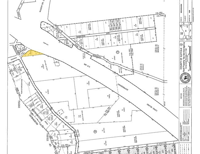
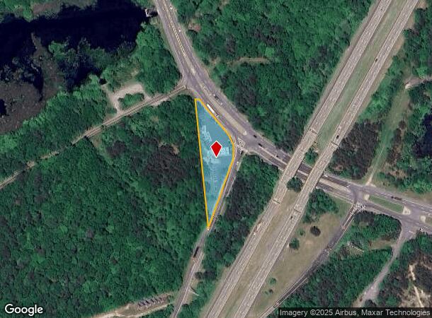
Property Record
1 Edwards Ave, Calverton, NY 11933
NEARBY LISTINGS FOR SALE OR LEASE
Property Detail
1 Edwards Ave
Nassau County-Suffolk County, NY
Riverhead Calverton
0200-299-00-02-00-021-000
N TO PT&EDWARDSAVE E LI EXP SVCE RD
Supermarket
Suffolk
X
New York
36103C0463H
21
2024
0.99 AC
2024
Eastern Suffolk
159410
Long Island (New York)
DEMOGRAPHICS near 1 Edwards Ave
1 Mile
3 Mile
5 Mile
2024 Total Population
874
6,000
33,308
2029 Population
870
5,924
33,245
Pop Growth 2024-2029
(0.46%)
(1.27%)
(0.19%)
Average Age
38
47
44
2024 Total Households
309
2,585
12,477
HH Growth 2024-2029
(0.65%)
(1.55%)
(0.25%)
Median Household Inc
$82,589
$63,684
$71,780
Avg Household Size
2.70
2.30
2.60
2024 Avg HH Vehicles
2.00
2.00
2.00
Median Home Value
$376,922
$287,292
$446,538
Median Year Built
1978
1984
1989
Nearby Places
- Restaurants
- Banks
- Shops
- Fitness
- Groceries
PUBLIC TRANSPORTATION
COMMUTER RAIL
Riverhead Station (Greenport Branch - Long Island Rail Road)
DRIVE
WALK
Distance
Riverhead Station (Greenport Branch - Long Island Rail Road)
7 min
4.6 mi
AIRPORT
Long Island MacArthur
DRIVE
WALK
Distance
Long Island MacArthur
36 min
23.4 mi
Freight Ports
Port of New Haven
DRIVE
WALK
Distance
Port of New Haven
142 min
56.9 mi
Nearby Properties
Address
Land Use
TOTAL SIZE
Lot Size
Zoning
Address
Land Use
TOTAL SIZE
Lot Size
Zoning
42.70 AC
9
Address
Land Use
TOTAL SIZE
Lot Size
Zoning
1,980.10 AC
10
Address
Land Use
TOTAL SIZE
Lot Size
Zoning
47.30 AC
9
Address
Land Use
TOTAL SIZE
Lot Size
Zoning
127,334 SF
49.72 AC
04
Address
Land Use
TOTAL SIZE
Lot Size
Zoning
109.90 AC
Address
Land Use
TOTAL SIZE
Lot Size
Zoning
17 AC
CR200
Address
Land Use
TOTAL SIZE
Lot Size
Zoning
95.60 AC
PIP
Address
Land Use
TOTAL SIZE
Lot Size
Zoning
2,010 SF
115.10 AC
09
Address
Land Use
TOTAL SIZE
Lot Size
Zoning
25,620 SF
7.03 AC
9
Address
Land Use
TOTAL SIZE
Lot Size
Zoning
9,715 SF
82.50 AC
9
Address
Land Use
TOTAL SIZE
Lot Size
Zoning
13.92 AC
04
Address
Land Use
TOTAL SIZE
Lot Size
Zoning
20.72 AC
09
Address
Land Use
TOTAL SIZE
Lot Size
Zoning
26.39 AC
04
Address
Land Use
TOTAL SIZE
Lot Size
Zoning
92.73 AC
Address
Land Use
TOTAL SIZE
Lot Size
Zoning
1,435 SF
13.20 AC
Address
Land Use
TOTAL SIZE
Lot Size
Zoning
32.33 AC
Address
Land Use
TOTAL SIZE
Lot Size
Zoning
1,190 SF
32.16 AC
09
Address
Land Use
TOTAL SIZE
Lot Size
Zoning
45.10 AC
Address
Land Use
TOTAL SIZE
Lot Size
Zoning
70,775 SF
13 AC
4
Address
Land Use
TOTAL SIZE
Lot Size
Zoning
66,340 SF
6.81 AC
BC
Address
Land Use
TOTAL SIZE
Lot Size
Zoning
1,333 SF
4.20 AC
CR200
Address
Land Use
TOTAL SIZE
Lot Size
Zoning
32.44 AC
Address
Land Use
TOTAL SIZE
Lot Size
Zoning
159.70 AC
CR200
Address
Land Use
TOTAL SIZE
Lot Size
Zoning
15,840 SF
50 AC
LI
Address
Land Use
TOTAL SIZE
Lot Size
Zoning
191.70 AC
04
Address
Land Use
TOTAL SIZE
Lot Size
Zoning
49,960 SF
5.08 AC
09
Address
Land Use
TOTAL SIZE
Lot Size
Zoning
131,859 SF
28.62 AC
09
Address
Land Use
TOTAL SIZE
Lot Size
Zoning
2,880 SF
5.20 AC
09
Address
Land Use
TOTAL SIZE
Lot Size
Zoning
46,150 SF
2 AC
9
Address
Land Use
TOTAL SIZE
Lot Size
Zoning
13.50 AC
CR200
The World's #1 Commercial Real Estate Marketplace
Connect with us
© 2025 CoStar Group
The information above has been obtained from sources believed reliable. While we do not doubt its accuracy we have not verified it and make no guarantee, warranty or representation about it. It is your responsibility to independently confirm its accuracy and completeness. Any projections, opinions, assumptions, or estimates used are for example only and do not represent the current or future performance of the property. The value of this transaction to you depends on tax and other factors which should be evaluated by your tax, financial, and legal advisors. You and your advisors should conduct a careful, independent investigation of the property to determine to your satisfaction the suitability of the property for your needs.