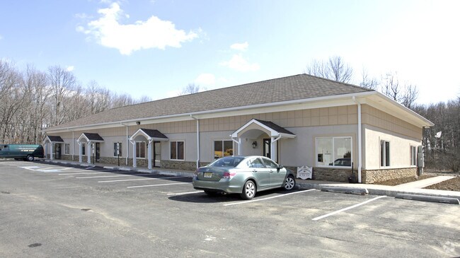
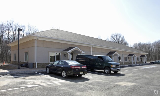
Property Record
1 Executive Dr, Monmouth Junction, NJ 08852
NEARBY LISTINGS FOR SALE OR LEASE
Property Detail
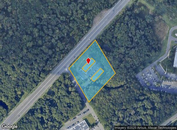
1 Executive Dr
21-00086-04-00021-04
3.53 AC COMMON ELEMENT
Officebuilding
Middlesex
X
New Jersey
34023C0116F
21.4
0
3.53 AC
2025
Brunswick West
008501
Northern New Jersey
1,521 SF
New York-Jersey City-White Plains, NY-NJ
DEMOGRAPHICS near 1 Executive Dr
1 Mile
3 Mile
5 Mile
2024 Total Population
5,838
68,782
111,181
2029 Population
5,818
68,722
110,843
Pop Growth 2024-2029
(0.34%)
(0.09%)
(0.30%)
Average Age
38
39
40
2024 Total Households
1,977
24,342
38,748
HH Growth 2024-2029
(0.46%)
(0.15%)
(0.37%)
Median Household Inc
$126,258
$117,375
$121,862
Avg Household Size
2.90
2.80
2.80
2024 Avg HH Vehicles
2.00
2.00
2.00
Median Home Value
$639,502
$444,541
$465,519
Median Year Built
1985
1988
1986
Nearby Places
Map Layers
Map Styles
 Street
 Aerial
- Restaurants
- Banks
- Shops
- Fitness
- Groceries
PUBLIC TRANSPORTATION
COMMUTER RAIL
Jersey Avenue (Northeast Corridor Line - NJ Transit Commuter Rail (NJ Transit))
DRIVE
WALK
Distance
Jersey Avenue (Northeast Corridor Line - NJ Transit Commuter Rail (NJ Transit))
14 min
5.8 mi
New Brunswick (Northeast Corridor Line - NJ Transit Commuter Rail (NJ Transit))
DRIVE
WALK
Distance
New Brunswick (Northeast Corridor Line - NJ Transit Commuter Rail (NJ Transit))
14 min
7.6 mi
AIRPORT
Trenton Mercer
DRIVE
WALK
Distance
Trenton Mercer
31 min
22.5 mi
Newark Liberty International
DRIVE
WALK
Distance
Newark Liberty International
44 min
34.4 mi
Freight Ports
New York Container Terminal
DRIVE
WALK
Distance
New York Container Terminal
39 min
27.2 mi
Nearby Properties
Address
Land Use
TOTAL SIZE
Lot Size
Zoning
Address
Land Use
TOTAL SIZE
Lot Size
Zoning
31.07 AC
ERR
Address
Land Use
TOTAL SIZE
Lot Size
Zoning
2,530 SF
20.05 AC
R10B
Address
Land Use
TOTAL SIZE
Lot Size
Zoning
34.75 AC
CR
Address
Land Use
TOTAL SIZE
Lot Size
Zoning
27.23 AC
CR
Address
Land Use
TOTAL SIZE
Lot Size
Zoning
103.93 AC
ERR
Address
Land Use
TOTAL SIZE
Lot Size
Zoning
419,094 SF
49.17 AC
CR
Address
Land Use
TOTAL SIZE
Lot Size
Zoning
0.46 AC
AH
Address
Land Use
TOTAL SIZE
Lot Size
Zoning
141,554 SF
15 AC
NB
Address
Land Use
TOTAL SIZE
Lot Size
Zoning
2,676 SF
16.50 AC
CR
Address
Land Use
TOTAL SIZE
Lot Size
Zoning
95,064 SF
14.41 AC
CR
Address
Land Use
TOTAL SIZE
Lot Size
Zoning
42.66 AC
PUD2
Address
Land Use
TOTAL SIZE
Lot Size
Zoning
192,072 SF
19.83 AC
CR
Address
Land Use
TOTAL SIZE
Lot Size
Zoning
72.62 AC
PL
Address
Land Use
TOTAL SIZE
Lot Size
Zoning
23.39 AC
PUD2
Address
Land Use
TOTAL SIZE
Lot Size
Zoning
97,470 SF
11 AC
NB
Address
Land Use
TOTAL SIZE
Lot Size
Zoning
28.96 AC
R10B
Address
Land Use
TOTAL SIZE
Lot Size
Zoning
27.47 AC
R5
Address
Land Use
TOTAL SIZE
Lot Size
Zoning
3,555 SF
25.73 AC
PL
Address
Land Use
TOTAL SIZE
Lot Size
Zoning
6.36 AC
R10B
Address
Land Use
TOTAL SIZE
Lot Size
Zoning
Address
Land Use
TOTAL SIZE
Lot Size
Zoning
17.13 AC
PUD2
Address
Land Use
TOTAL SIZE
Lot Size
Zoning
48.73 AC
ERR
Address
Land Use
TOTAL SIZE
Lot Size
Zoning
249 SF
19.46 AC
R6
Address
Land Use
TOTAL SIZE
Lot Size
Zoning
626,675 SF
54.07 AC
LI-2
Address
Land Use
TOTAL SIZE
Lot Size
Zoning
22.82 AC
PUD2
Address
Land Use
TOTAL SIZE
Lot Size
Zoning
23.58 AC
PL
Address
Land Use
TOTAL SIZE
Lot Size
Zoning
14.97 AC
PUD2
Address
Land Use
TOTAL SIZE
Lot Size
Zoning
179 SF
11.77 AC
R6
Address
Land Use
TOTAL SIZE
Lot Size
Zoning
13.20 AC
TMU
Address
Land Use
TOTAL SIZE
Lot Size
Zoning
23.67 AC
I2
The World's #1 Commercial Real Estate Marketplace
Connect with us
© 2025 CoStar Group
The information above has been obtained from sources believed reliable. While we do not doubt its accuracy we have not verified it and make no guarantee, warranty or representation about it. It is your responsibility to independently confirm its accuracy and completeness. Any projections, opinions, assumptions, or estimates used are for example only and do not represent the current or future performance of the property. The value of this transaction to you depends on tax and other factors which should be evaluated by your tax, financial, and legal advisors. You and your advisors should conduct a careful, independent investigation of the property to determine to your satisfaction the suitability of the property for your needs.