Property Record
1 Firestone Dr, Suffield, CT 06078
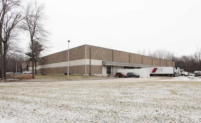

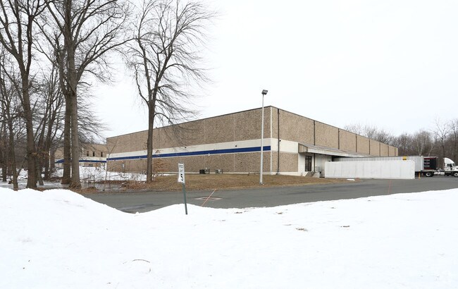
Property Detail
1 Firestone Dr
SUFF-000037H-000037-000003
Capitol
Manufacturinglight
Connecticut
PDIP
3
C and X Area of minimal flood hazard, usually depicted on FIRMs as above the 500-year flood level.
5.81 AC
2025
Suffield
2025
Hartford
477104
Hartford-West Hartford-East Hartford, CT
90,925 SF
NEARBY LISTINGS FOR SALE OR LEASE
DEMOGRAPHICS near 1 Firestone Dr
1 mile
3 mile
5 mile
2024 Total Population
1,328
22,206
59,875
2029 Population
1,360
22,741
61,251
Pop Growth 2024-2029
+ 2.41%
+ 2.41%
+ 2.30%
Average Age
41
44
43
2024 Total Households
474
9,031
24,360
HH Growth 2024-2029
+ 2.53%
+ 2.51%
+ 2.33%
Median Household Inc
$162,873
$94,866
$92,783
Avg Household Size
2.60
2.30
2.30
2024 Avg HH Vehicles
2.00
2.00
2.00
Median Home Value
$430,158
$302,458
$295,991
Median Year Built
1995
1968
1967
Nearby Places
Map Layers
Map Styles
 Street
 Aerial
Transit
 Traffic
 Biking
Places
Listings with unknown addresses are not visible on the map
- Restaurants
- Banks
- Shops
- Fitness
- Groceries
PUBLIC TRANSPORTATION
COMMUTER RAIL
Windsor Locks (Hartford Line - CT Rail (CTRail))
Drive
Walk
Distance
Windsor Locks (Hartford Line - CT Rail (CTRail))
9 min
3.7 mi
Drive
Walk
Distance
18 min
8.4 mi
AIRPORT
Bradley International
Drive
Walk
Distance
Bradley International
10 min
2.8 mi
Freight Ports
Port of New Haven
Drive
Walk
Distance
Port of New Haven
75 min
54.3 mi
Nearby Properties
Address
Land Use
TOTAL SIZE
Lot Size
Zoning
Address
Land Use
TOTAL SIZE
Lot Size
Zoning
723,830 SF
160.79 AC
IND1
Address
Land Use
TOTAL SIZE
Lot Size
Zoning
Address
Land Use
TOTAL SIZE
Lot Size
Zoning
30.30 AC
R25
Address
Land Use
TOTAL SIZE
Lot Size
Zoning
207,981 SF
60.48 AC
R45
Address
Land Use
TOTAL SIZE
Lot Size
Zoning
6,000 SF
62.78 AC
IND1
Address
Land Use
TOTAL SIZE
Lot Size
Zoning
64.41 AC
IND3
Address
Land Use
TOTAL SIZE
Lot Size
Zoning
32.40 AC
R90
Address
Land Use
TOTAL SIZE
Lot Size
Zoning
64,798 SF
1 AC
Address
Land Use
TOTAL SIZE
Lot Size
Zoning
143,800 SF
Address
Land Use
TOTAL SIZE
Lot Size
Zoning
176,152 SF
27 AC
R44
Address
Land Use
TOTAL SIZE
Lot Size
Zoning
177,366 SF
61.60 AC
RESA
Address
Land Use
TOTAL SIZE
Lot Size
Zoning
64.46 AC
R25
Address
Land Use
TOTAL SIZE
Lot Size
Zoning
12.14 AC
I
Address
Land Use
TOTAL SIZE
Lot Size
Zoning
124,964 SF
RESA
Address
Land Use
TOTAL SIZE
Lot Size
Zoning
135,228 SF
19.50 AC
R45
Address
Land Use
TOTAL SIZE
Lot Size
Zoning
Address
Land Use
TOTAL SIZE
Lot Size
Zoning
21.50 AC
R25
Address
Land Use
TOTAL SIZE
Lot Size
Zoning
451,937 SF
25.93 AC
IND3
Address
Land Use
TOTAL SIZE
Lot Size
Zoning
14,295 SF
24.45 AC
R-1
Address
Land Use
TOTAL SIZE
Lot Size
Zoning
14,864 SF
0.25 AC
IND1
Address
Land Use
TOTAL SIZE
Lot Size
Zoning
15.58 AC
RESA
Address
Land Use
TOTAL SIZE
Lot Size
Zoning
50,287 SF
1.74 AC
Address
Land Use
TOTAL SIZE
Lot Size
Zoning
243,624 SF
12.16 AC
I
Address
Land Use
TOTAL SIZE
Lot Size
Zoning
46,206 SF
2.70 AC
BUS1
Address
Land Use
TOTAL SIZE
Lot Size
Zoning
20.54 AC
R33
Address
Land Use
TOTAL SIZE
Lot Size
Zoning
80,408 SF
2.59 AC
BUS1
Address
Land Use
TOTAL SIZE
Lot Size
Zoning
106,851 SF
20.33 AC
R25
Address
Land Use
TOTAL SIZE
Lot Size
Zoning
260,002 SF
9.89 AC
IND3
Address
Land Use
TOTAL SIZE
Lot Size
Zoning
Address
Land Use
TOTAL SIZE
Lot Size
Zoning
10 AC
R45
The World's #1 Commercial Real Estate Marketplace
Connect with us
© 2026 CoStar Group
The information above has been obtained from sources believed reliable. While we do not doubt its accuracy we have not verified it and make no guarantee, warranty or representation about it. It is your responsibility to independently confirm its accuracy and completeness. Any projections, opinions, assumptions, or estimates used are for example only and do not represent the current or future performance of the property. The value of this transaction to you depends on tax and other factors which should be evaluated by your tax, financial, and legal advisors. You and your advisors should conduct a careful, independent investigation of the property to determine to your satisfaction the suitability of the property for your needs.