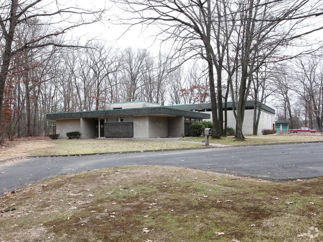
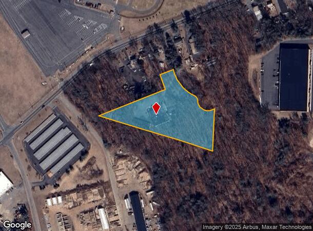
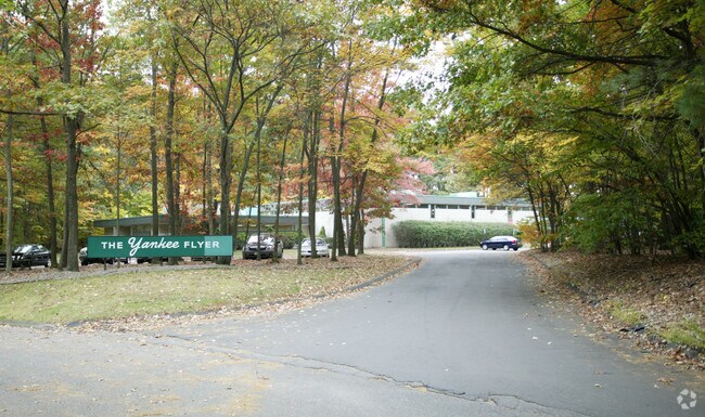
Property Record
1 Flyer Row, Bloomfield, CT 06002
Property Detail
1 Flyer Row
BLOO-000374-000000-001016-R002781
Hartford
Industrialgeneral
Connecticut
X
7
09003C0352F
3.03 AC
2024
Bloomfield
2025
Hartford
471500
Hartford-West Hartford-East Hartford, CT
9,870 SF
NEARBY LISTINGS FOR SALE OR LEASE
DEMOGRAPHICS near 1 Flyer Row
1 mile
3 mile
5 mile
2024 Total Population
232
31,237
82,724
2029 Population
231
31,124
82,286
Pop Growth 2024-2029
(0.43%)
(0.36%)
(0.53%)
Average Age
46
44
42
2024 Total Households
97
12,315
31,304
HH Growth 2024-2029
(1.03%)
(0.54%)
(0.62%)
Median Household Inc
$107,031
$89,073
$81,586
Avg Household Size
2.30
2.40
2.40
2024 Avg HH Vehicles
2.00
2.00
2.00
Median Home Value
$292,592
$241,462
$245,572
Median Year Built
1986
1969
1964
Nearby Places
Map Layers
Map Styles
 Street
 Aerial
Transit
 Traffic
 Biking
Places
Listings with unknown addresses are not visible on the map
- Restaurants
- Banks
- Shops
- Fitness
- Groceries
PUBLIC TRANSPORTATION
COMMUTER RAIL
Windsor (Hartford Line - CONN DOT)
Drive
Walk
Distance
Windsor (Hartford Line - CONN DOT)
8 min
3.3 mi
Windsor Locks (Hartford Line - CT Rail (CTRail))
Drive
Walk
Distance
Windsor Locks (Hartford Line - CT Rail (CTRail))
11 min
7.1 mi
AIRPORT
Bradley International
Drive
Walk
Distance
Bradley International
27 min
10.1 mi
Freight Ports
Port of New Haven
Drive
Walk
Distance
Port of New Haven
63 min
47.1 mi
Nearby Properties
Address
Land Use
TOTAL SIZE
Lot Size
Zoning
Address
Land Use
TOTAL SIZE
Lot Size
Zoning
105,796 SF
89.51 AC
Address
Land Use
TOTAL SIZE
Lot Size
Zoning
66.60 AC
I-2
Address
Land Use
TOTAL SIZE
Lot Size
Zoning
802,150 SF
96.24 AC
I-2
Address
Land Use
TOTAL SIZE
Lot Size
Zoning
68.36 AC
Address
Land Use
TOTAL SIZE
Lot Size
Zoning
227,898 SF
5.33 AC
BCD
Address
Land Use
TOTAL SIZE
Lot Size
Zoning
433,356 SF
45.53 AC
I-2
Address
Land Use
TOTAL SIZE
Lot Size
Zoning
93.79 AC
Address
Land Use
TOTAL SIZE
Lot Size
Zoning
65,042 SF
36.76 AC
I-2
Address
Land Use
TOTAL SIZE
Lot Size
Zoning
8.89 AC
Address
Land Use
TOTAL SIZE
Lot Size
Zoning
161,576 SF
4 AC
BCD
Address
Land Use
TOTAL SIZE
Lot Size
Zoning
82,938 SF
62.53 AC
I-1
Address
Land Use
TOTAL SIZE
Lot Size
Zoning
77,497 SF
14.17 AC
R-20
Address
Land Use
TOTAL SIZE
Lot Size
Zoning
135,344 SF
17.85 AC
PO
Address
Land Use
TOTAL SIZE
Lot Size
Zoning
180,964 SF
32.10 AC
R-15
Address
Land Use
TOTAL SIZE
Lot Size
Zoning
14.02 AC
PLR
Address
Land Use
TOTAL SIZE
Lot Size
Zoning
203,071 SF
17.46 AC
Address
Land Use
TOTAL SIZE
Lot Size
Zoning
39.47 AC
R-15
Address
Land Use
TOTAL SIZE
Lot Size
Zoning
451,806 SF
37.82 AC
I-2
Address
Land Use
TOTAL SIZE
Lot Size
Zoning
53.78 AC
R-30
Address
Land Use
TOTAL SIZE
Lot Size
Zoning
177,630 SF
32.64 AC
Address
Land Use
TOTAL SIZE
Lot Size
Zoning
247,428 SF
35.46 AC
Address
Land Use
TOTAL SIZE
Lot Size
Zoning
215,269 SF
41 AC
I-2
Address
Land Use
TOTAL SIZE
Lot Size
Zoning
488,812 SF
77.31 AC
Address
Land Use
TOTAL SIZE
Lot Size
Zoning
152,382 SF
10.46 AC
Address
Land Use
TOTAL SIZE
Lot Size
Zoning
183,263 SF
21.69 AC
Address
Land Use
TOTAL SIZE
Lot Size
Zoning
457,396 SF
72.99 AC
Address
Land Use
TOTAL SIZE
Lot Size
Zoning
14.90 AC
R-15
Address
Land Use
TOTAL SIZE
Lot Size
Zoning
62,592 SF
31.12 AC
R-15
Address
Land Use
TOTAL SIZE
Lot Size
Zoning
15.33 AC
R-15
Address
Land Use
TOTAL SIZE
Lot Size
Zoning
25,622 SF
19.80 AC
PLR
The World's #1 Commercial Real Estate Marketplace
Connect with us
© 2026 CoStar Group
The information above has been obtained from sources believed reliable. While we do not doubt its accuracy we have not verified it and make no guarantee, warranty or representation about it. It is your responsibility to independently confirm its accuracy and completeness. Any projections, opinions, assumptions, or estimates used are for example only and do not represent the current or future performance of the property. The value of this transaction to you depends on tax and other factors which should be evaluated by your tax, financial, and legal advisors. You and your advisors should conduct a careful, independent investigation of the property to determine to your satisfaction the suitability of the property for your needs.