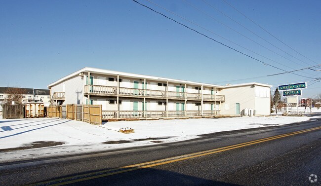
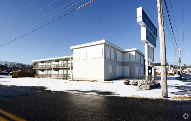
Property Record
1 Heath St, Old Orchard Beach, ME 04064
NEARBY LISTINGS FOR SALE OR LEASE
-
-
View all Old Orchard Beach listings for sale on LoopNet.com
Property Detail
1 Heath St
OOBH-000309-000009-000030
York
Parkinglot
Maine
X
30
23031C0319G
0.93 AC
2024
York County
2024
Portland/South Portland
006106
Portland-South Portland, ME
14,992 SF
DEMOGRAPHICS near 1 Heath St
1 Mile
3 Mile
5 Mile
2024 Total Population
6,058
20,945
53,989
2029 Population
6,706
22,774
57,532
Pop Growth 2024-2029
+ 10.70%
+ 8.73%
+ 6.56%
Average Age
49
48
43
2024 Total Households
3,194
10,109
24,298
HH Growth 2024-2029
+ 10.52%
+ 8.87%
+ 6.79%
Median Household Inc
$68,643
$76,453
$67,128
Avg Household Size
1.80
2.00
2.10
2024 Avg HH Vehicles
2.00
2.00
2.00
Median Home Value
$313,611
$354,259
$347,020
Median Year Built
1963
1983
1977
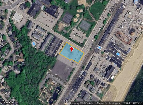
Nearby Places
Map Layers
Map Styles
 Street
 Aerial
- Restaurants
- Banks
- Shops
- Fitness
- Groceries
PUBLIC TRANSPORTATION
COMMUTER RAIL
Old Orchard Beach Amtrak (Downeaster - Amtrak)
DRIVE
WALK
Distance
Old Orchard Beach Amtrak (Downeaster - Amtrak)
0 min
2 min
0.1 mi
Saco Amtrak Station (Downeaster - Amtrak)
DRIVE
WALK
Distance
Saco Amtrak Station (Downeaster - Amtrak)
9 min
4.5 mi
AIRPORT
Portland International Jetport
DRIVE
WALK
Distance
Portland International Jetport
24 min
16.1 mi
Freight Ports
Portland, ME
DRIVE
WALK
Distance
Portland, ME
25 min
18.8 mi
Nearby Properties
Address
Land Use
TOTAL SIZE
Lot Size
Zoning
Address
Land Use
TOTAL SIZE
Lot Size
Zoning
2,295.68 AC
B-6
Address
Land Use
TOTAL SIZE
Lot Size
Zoning
7.86 AC
B2A
Address
Land Use
TOTAL SIZE
Lot Size
Zoning
2,637 SF
81.33 AC
MZ
Address
Land Use
TOTAL SIZE
Lot Size
Zoning
2.50 AC
R-1
Address
Land Use
TOTAL SIZE
Lot Size
Zoning
708 SF
52.01 AC
R-4
Address
Land Use
TOTAL SIZE
Lot Size
Zoning
62,610 SF
2.61 AC
R-1A
Address
Land Use
TOTAL SIZE
Lot Size
Zoning
19,725 SF
45.64 AC
16
Address
Land Use
TOTAL SIZE
Lot Size
Zoning
52,582 SF
12.58 AC
B-6
Address
Land Use
TOTAL SIZE
Lot Size
Zoning
3,033 SF
55.01 AC
RD
Address
Land Use
TOTAL SIZE
Lot Size
Zoning
49,518 SF
5.60 AC
R-1A
Address
Land Use
TOTAL SIZE
Lot Size
Zoning
63,300 SF
11.76 AC
B-2D
Address
Land Use
TOTAL SIZE
Lot Size
Zoning
104.72 AC
B-6
Address
Land Use
TOTAL SIZE
Lot Size
Zoning
4,296 SF
27.94 AC
MZ
Address
Land Use
TOTAL SIZE
Lot Size
Zoning
47,532 SF
4.76 AC
MZ
Address
Land Use
TOTAL SIZE
Lot Size
Zoning
7,216 SF
10.40 AC
MZ
Address
Land Use
TOTAL SIZE
Lot Size
Zoning
5,000 SF
8.30 AC
PMUD
Address
Land Use
TOTAL SIZE
Lot Size
Zoning
39,552 SF
56.22 AC
B-6
Address
Land Use
TOTAL SIZE
Lot Size
Zoning
8,007 SF
1.04 AC
12
Address
Land Use
TOTAL SIZE
Lot Size
Zoning
24,192 SF
1.80 AC
BRD
Address
Land Use
TOTAL SIZE
Lot Size
Zoning
1,768 SF
21.12 AC
MZ
Address
Land Use
TOTAL SIZE
Lot Size
Zoning
5.98 AC
MU3
Address
Land Use
TOTAL SIZE
Lot Size
Zoning
46,250 SF
2.14 AC
RBD
Address
Land Use
TOTAL SIZE
Lot Size
Zoning
15,043 SF
10.91 AC
MU3
Address
Land Use
TOTAL SIZE
Lot Size
Zoning
43.51 AC
R-4
Address
Land Use
TOTAL SIZE
Lot Size
Zoning
2.30 AC
ID
Address
Land Use
TOTAL SIZE
Lot Size
Zoning
2,260 SF
4.05 AC
R-3
Address
Land Use
TOTAL SIZE
Lot Size
Zoning
46,230 SF
12.10 AC
B-6
Address
Land Use
TOTAL SIZE
Lot Size
Zoning
2,986 SF
37.10 AC
R-1
Address
Land Use
TOTAL SIZE
Lot Size
Zoning
1.02 AC
15
Address
Land Use
TOTAL SIZE
Lot Size
Zoning
3,400 SF
7.34 AC
MZ
The World's #1 Commercial Real Estate Marketplace
Connect with us
© 2025 CoStar Group
The information above has been obtained from sources believed reliable. While we do not doubt its accuracy we have not verified it and make no guarantee, warranty or representation about it. It is your responsibility to independently confirm its accuracy and completeness. Any projections, opinions, assumptions, or estimates used are for example only and do not represent the current or future performance of the property. The value of this transaction to you depends on tax and other factors which should be evaluated by your tax, financial, and legal advisors. You and your advisors should conduct a careful, independent investigation of the property to determine to your satisfaction the suitability of the property for your needs.