Property Record
1 Industry Way, Staunton, VA 24401


Save to a Folder
{{folder.Name}}
{{folder.ListingIds.length}} Properties
{{folder.ListingIds.length}} Property
Create a New Folder
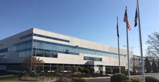
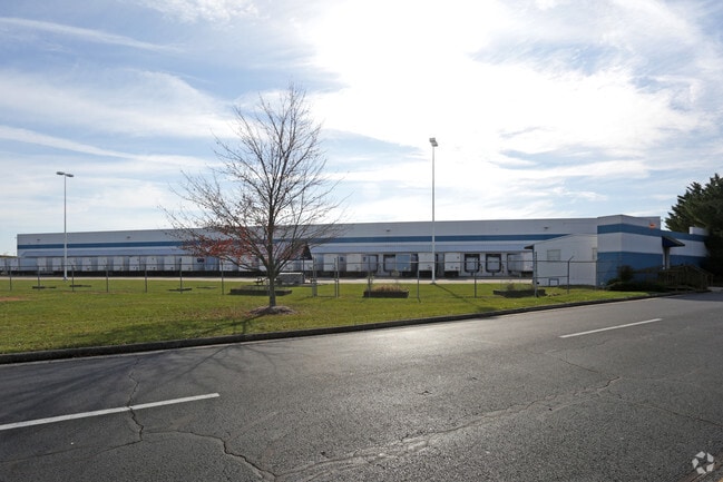
Property Detail
1 Industry Way
11083
PARCEL B (ON PLAT OF DIV-BRUCE MCINTOSH II PROP)-46.550 AC (BEST BUY SITE)
Warehouse
Staunton City
I2
Virginia
B and X Area of moderate flood hazard, usually the area between the limits of the 100-year and 500-year floods.
46.55 AC
2025
Staunton & Harrisonburg
2025
Other Market Areas
000500
Staunton-Stuarts Draft, VA
700,000 SF
NEARBY LISTINGS FOR SALE OR LEASE
-
-
View all Staunton listings for lease on LoopNet.com
DEMOGRAPHICS near 1 Industry Way
1 mile
3 mile
5 mile
2025 Total Population
315
13,261
36,543
2030 Population
329
13,545
37,427
Pop Growth 2025-2030
+ 4.44%
+ 2.14%
+ 2.42%
Average Age
47
43
43
2025 Total Households
127
5,181
15,577
HH Growth 2025-2030
+ 4.72%
+ 2.41%
+ 2.64%
Median Household Inc
$102,778
$70,034
$62,633
Avg Household Size
2.20
2.20
2.20
2025 Avg HH Vehicles
2.00
2.00
2.00
Median Home Value
$316,667
$289,282
$263,985
Median Year Built
1965
1971
1969
Nearby Places
Map Layers
Map Styles
 Street
 Aerial
Layers
 Traffic
 Biking
Places
Listings with unknown addresses are not visible on the map
- Restaurants
- Banks
- Shops
- Fitness
- Groceries
PUBLIC TRANSPORTATION
COMMUTER RAIL
Staunton Amtrak Station (Cardinal - Amtrak)
Drive
Walk
Distance
Staunton Amtrak Station (Cardinal - Amtrak)
8 min
4.4 mi
Freight Ports
Virginia Port Authority - Richmond
Drive
Walk
Distance
Virginia Port Authority - Richmond
137 min
116.9 mi
SALE & LEASE HISTORY
LISTING DATE
SALE/LEASE

Mar 21, 2017
For Lease
Mar 01, 2017
For Lease
Nearby Properties
Address
Land Use
TOTAL SIZE
Lot Size
Zoning
Address
Land Use
TOTAL SIZE
Lot Size
Zoning
360,085 SF
66.35 AC
I-1
Address
Land Use
TOTAL SIZE
Lot Size
Zoning
132,832 SF
50.44 AC
GENERAL BU
Address
Land Use
TOTAL SIZE
Lot Size
Zoning
262,369 SF
24.50 AC
GENERAL BU
Address
Land Use
TOTAL SIZE
Lot Size
Zoning
43,097 SF
72.85 AC
R3
Address
Land Use
TOTAL SIZE
Lot Size
Zoning
218,331 SF
40 AC
PLANNED CO
Address
Land Use
TOTAL SIZE
Lot Size
Zoning
4,232 SF
12.56 AC
GENERAL IN
Address
Land Use
TOTAL SIZE
Lot Size
Zoning
515,766 SF
81.76 AC
GENERAL IN
Address
Land Use
TOTAL SIZE
Lot Size
Zoning
101,384 SF
11.77 AC
R3
Address
Land Use
TOTAL SIZE
Lot Size
Zoning
222,668 SF
34.23 AC
I2
Address
Land Use
TOTAL SIZE
Lot Size
Zoning
38,772 SF
8.58 AC
GENERAL BU
Address
Land Use
TOTAL SIZE
Lot Size
Zoning
303,307 SF
146.93 AC
GENERAL IN
Address
Land Use
TOTAL SIZE
Lot Size
Zoning
158,300 SF
30 AC
R2
Address
Land Use
TOTAL SIZE
Lot Size
Zoning
61,798 SF
8.52 AC
R2
Address
Land Use
TOTAL SIZE
Lot Size
Zoning
48,904 SF
5.17 AC
P1
Address
Land Use
TOTAL SIZE
Lot Size
Zoning
107,455 SF
5.82 AC
P1
Address
Land Use
TOTAL SIZE
Lot Size
Zoning
174,284 SF
10.35 AC
GENERAL BU
Address
Land Use
TOTAL SIZE
Lot Size
Zoning
111,992 SF
7.13 AC
PLANNED CO
Address
Land Use
TOTAL SIZE
Lot Size
Zoning
101,604 SF
6.61 AC
R3
Address
Land Use
TOTAL SIZE
Lot Size
Zoning
107,814 SF
6.21 AC
R4
Address
Land Use
TOTAL SIZE
Lot Size
Zoning
41,954 SF
3.40 AC
R1
Address
Land Use
TOTAL SIZE
Lot Size
Zoning
107,440 SF
22.95 AC
GENERAL IN
Address
Land Use
TOTAL SIZE
Lot Size
Zoning
43,502 SF
15.61 AC
I2
Address
Land Use
TOTAL SIZE
Lot Size
Zoning
40,626 SF
8.51 AC
R3
Address
Land Use
TOTAL SIZE
Lot Size
Zoning
77,592 SF
9.49 AC
GENERAL BU
Address
Land Use
TOTAL SIZE
Lot Size
Zoning
65,080 SF
3.76 AC
R4
Address
Land Use
TOTAL SIZE
Lot Size
Zoning
20,858 SF
12.73 AC
GENERAL BU
Address
Land Use
TOTAL SIZE
Lot Size
Zoning
56,375 SF
4.69 AC
PLANNED CO
Address
Land Use
TOTAL SIZE
Lot Size
Zoning
46,074 SF
2.98 AC
R2
Address
Land Use
TOTAL SIZE
Lot Size
Zoning
40,146 SF
14.70 AC
R1
The World's #1 Commercial Real Estate Marketplace
Connect with us
© 2026 CoStar Group
The information above has been obtained from sources believed reliable. While we do not doubt its accuracy we have not verified it and make no guarantee, warranty or representation about it. It is your responsibility to independently confirm its accuracy and completeness. Any projections, opinions, assumptions, or estimates used are for example only and do not represent the current or future performance of the property. The value of this transaction to you depends on tax and other factors which should be evaluated by your tax, financial, and legal advisors. You and your advisors should conduct a careful, independent investigation of the property to determine to your satisfaction the suitability of the property for your needs.