Property Record
1 Kyle Dr, Pocasset, MA 02559


Save to a Folder
{{folder.Name}}
{{folder.ListingIds.length}} Properties
{{folder.ListingIds.length}} Property
Create a New Folder
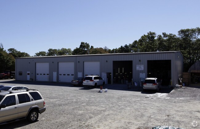
Property Detail
1 Kyle Dr
BOUR-000390-000068-000002
Barnstable
Commercialnec
Massachusetts
B and X Area of moderate flood hazard, usually the area between the limits of the 100-year and 500-year floods.
1.63 AC
2025
Other Market Areas
2025
Barnstable Town, MA
014002
NEARBY LISTINGS FOR SALE OR LEASE
DEMOGRAPHICS near 1 Kyle Dr
1 mile
3 mile
5 mile
2025 Total Population
1,389
7,397
24,146
2030 Population
1,328
7,110
23,588
Pop Growth 2025-2030
(4.39%)
(3.88%)
(2.31%)
Average Age
49
49
47
2025 Total Households
668
3,299
10,063
HH Growth 2025-2030
(4.79%)
(4.52%)
(2.52%)
Median Household Inc
$91,666
$91,045
$94,931
Avg Household Size
2.10
2.10
2.20
2025 Avg HH Vehicles
2.00
2.00
2.00
Median Home Value
$471,825
$656,487
$591,176
Median Year Built
1981
1976
1974
Nearby Places
Map Layers
Map Styles
 Street
 Aerial
Layers
 Traffic
 Biking
Places
Listings with unknown addresses are not visible on the map
- Restaurants
- Banks
- Shops
- Fitness
- Groceries
PUBLIC TRANSPORTATION
COMMUTER RAIL
Bourne (CapeFLYER - Cape Cod Regional Transit Authority)
Drive
Walk
Distance
Bourne (CapeFLYER - Cape Cod Regional Transit Authority)
7 min
4.3 mi
Buzzards Bay (CapeFLYER - Cape Cod Regional Transit Authority)
Drive
Walk
Distance
Buzzards Bay (CapeFLYER - Cape Cod Regional Transit Authority)
13 min
7.3 mi
AIRPORT
Martha's Vineyard
Drive
Walk
Distance
Martha's Vineyard
84 min
27.9 mi
Freight Ports
Port of New Bedford Harbor
Drive
Walk
Distance
Port of New Bedford Harbor
42 min
31.7 mi
Nearby Properties
Address
Land Use
TOTAL SIZE
Lot Size
Zoning
Address
Land Use
TOTAL SIZE
Lot Size
Zoning
46 AC
R40
Address
Land Use
TOTAL SIZE
Lot Size
Zoning
22,000 SF
749.29 AC
GD
Address
Land Use
TOTAL SIZE
Lot Size
Zoning
73,483 SF
16.18 AC
Address
Land Use
TOTAL SIZE
Lot Size
Zoning
74.05 AC
B-3
Address
Land Use
TOTAL SIZE
Lot Size
Zoning
68.53 AC
R40
Address
Land Use
TOTAL SIZE
Lot Size
Zoning
11.20 AC
Address
Land Use
TOTAL SIZE
Lot Size
Zoning
17.50 AC
Address
Land Use
TOTAL SIZE
Lot Size
Zoning
57,942 SF
7.20 AC
Address
Land Use
TOTAL SIZE
Lot Size
Zoning
45.85 AC
Address
Land Use
TOTAL SIZE
Lot Size
Zoning
2.82 AC
Address
Land Use
TOTAL SIZE
Lot Size
Zoning
1,452 SF
6.70 AC
Address
Land Use
TOTAL SIZE
Lot Size
Zoning
15.80 AC
Address
Land Use
TOTAL SIZE
Lot Size
Zoning
Address
Land Use
TOTAL SIZE
Lot Size
Zoning
3,172 SF
2.23 AC
R40
Address
Land Use
TOTAL SIZE
Lot Size
Zoning
Address
Land Use
TOTAL SIZE
Lot Size
Zoning
10.02 AC
R40
Address
Land Use
TOTAL SIZE
Lot Size
Zoning
7,856 SF
5.34 AC
R40
Address
Land Use
TOTAL SIZE
Lot Size
Zoning
38,800 SF
5.24 AC
B-4
Address
Land Use
TOTAL SIZE
Lot Size
Zoning
2.70 AC
R40
Address
Land Use
TOTAL SIZE
Lot Size
Zoning
6,853 SF
4.30 AC
R40
Address
Land Use
TOTAL SIZE
Lot Size
Zoning
118.50 AC
R40
Address
Land Use
TOTAL SIZE
Lot Size
Zoning
6,413 SF
3.23 AC
R40
Address
Land Use
TOTAL SIZE
Lot Size
Zoning
7,504 SF
1.15 AC
B-2
Address
Land Use
TOTAL SIZE
Lot Size
Zoning
2,951 SF
0.90 AC
R40
Address
Land Use
TOTAL SIZE
Lot Size
Zoning
5.40 AC
R-80
Address
Land Use
TOTAL SIZE
Lot Size
Zoning
0.72 AC
R40
Address
Land Use
TOTAL SIZE
Lot Size
Zoning
17,249 SF
4.10 AC
Address
Land Use
TOTAL SIZE
Lot Size
Zoning
10,443 SF
0.70 AC
Address
Land Use
TOTAL SIZE
Lot Size
Zoning
11.64 AC
R40
Address
Land Use
TOTAL SIZE
Lot Size
Zoning
7.70 AC
R40
The World's #1 Commercial Real Estate Marketplace
Connect with us
© 2026 CoStar Group
The information above has been obtained from sources believed reliable. While we do not doubt its accuracy we have not verified it and make no guarantee, warranty or representation about it. It is your responsibility to independently confirm its accuracy and completeness. Any projections, opinions, assumptions, or estimates used are for example only and do not represent the current or future performance of the property. The value of this transaction to you depends on tax and other factors which should be evaluated by your tax, financial, and legal advisors. You and your advisors should conduct a careful, independent investigation of the property to determine to your satisfaction the suitability of the property for your needs.