Property Record
1 Lake Shore Dr, Pierson, FL 32180
NEARBY LISTINGS FOR SALE OR LEASE
-
-
View all Pierson listings for sale on LoopNet.com
Property Detail
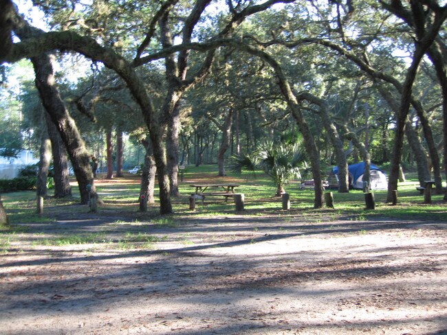
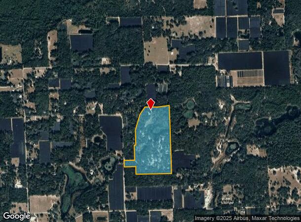
1 Lake Shore Dr
4826-00-00-0043
Parcel
Recreationalentertainmentgeneral
26 14 28 S 3/4 OF E 1/4 OF SW 1/4 OF NE 1/4 EXC N 548.3 FT & EXC IRREG PARCEL PER OR 1716 PG 0557 & E 3/4 OF NW 1/4 OF SE 1/4 & N 315.15 FT OF E 3/4 OF SW 1/4 OF SE 1/4 EXC IRREG PARCEL PER OR 1716 PG 0557 & S 100 FT OF W 1/4 OF NW 1/4 OF SE 1/4 & N
A
Volusia
12127C0150J
Florida
2025
11.36 AC
2026
NW Volusia County
090101
Deltona/Daytona Beach
2,268 SF
Deltona-Daytona Beach-Ormond Beach, FL
DEMOGRAPHICS near 1 Lake Shore Dr
1 Mile
3 Mile
5 Mile
2024 Total Population
473
1,974
3,315
2029 Population
515
2,161
3,635
Pop Growth 2024-2029
+ 8.88%
+ 9.47%
+ 9.65%
Average Age
43
41
42
2024 Total Households
179
684
1,193
HH Growth 2024-2029
+ 9.50%
+ 9.50%
+ 9.72%
Median Household Inc
$65,250
$64,583
$64,682
Avg Household Size
2.50
2.70
2.60
2024 Avg HH Vehicles
2.00
2.00
2.00
Median Home Value
$267,856
$266,948
$273,134
Median Year Built
1978
1979
1979
Nearby Places
Map Layers
Map Styles
 Street
 Aerial
- Restaurants
- Banks
- Shops
- Fitness
- Groceries
PUBLIC TRANSPORTATION
AIRPORT
Daytona Beach International
DRIVE
WALK
Distance
Daytona Beach International
55 min
35.6 mi
Freight Ports
Jacksonville Port
DRIVE
WALK
Distance
Jacksonville Port
133 min
102.2 mi
Nearby Properties
Address
Land Use
TOTAL SIZE
Lot Size
Zoning
Address
Land Use
TOTAL SIZE
Lot Size
Zoning
227,542 SF
90.24 AC
Address
Land Use
TOTAL SIZE
Lot Size
Zoning
93,639 SF
23.48 AC
A1
Address
Land Use
TOTAL SIZE
Lot Size
Zoning
46,635 SF
6.17 AC
Address
Land Use
TOTAL SIZE
Lot Size
Zoning
27,005 SF
7.38 AC
14A1
Address
Land Use
TOTAL SIZE
Lot Size
Zoning
38,891 SF
20.30 AC
A1
Address
Land Use
TOTAL SIZE
Lot Size
Zoning
11,564 SF
4.24 AC
Address
Land Use
TOTAL SIZE
Lot Size
Zoning
11,076 SF
145 AC
A2
Address
Land Use
TOTAL SIZE
Lot Size
Zoning
5,121 SF
85.04 AC
RC
Address
Land Use
TOTAL SIZE
Lot Size
Zoning
10,672 SF
1.69 AC
Address
Land Use
TOTAL SIZE
Lot Size
Zoning
17,566 SF
2.47 AC
Address
Land Use
TOTAL SIZE
Lot Size
Zoning
6,327 SF
33 AC
Address
Land Use
TOTAL SIZE
Lot Size
Zoning
28,834 SF
16.02 AC
MPUD
Address
Land Use
TOTAL SIZE
Lot Size
Zoning
4,620 SF
4.81 AC
Address
Land Use
TOTAL SIZE
Lot Size
Zoning
5,232 SF
349.31 AC
RC
Address
Land Use
TOTAL SIZE
Lot Size
Zoning
207 AC
Address
Land Use
TOTAL SIZE
Lot Size
Zoning
4,724 SF
11.20 AC
Address
Land Use
TOTAL SIZE
Lot Size
Zoning
9,748 SF
0.96 AC
Address
Land Use
TOTAL SIZE
Lot Size
Zoning
3,962 SF
32.09 AC
Address
Land Use
TOTAL SIZE
Lot Size
Zoning
25,120 SF
4 AC
14B2
Address
Land Use
TOTAL SIZE
Lot Size
Zoning
8,494 SF
1.24 AC
Address
Land Use
TOTAL SIZE
Lot Size
Zoning
5,725 SF
9.50 AC
A1
Address
Land Use
TOTAL SIZE
Lot Size
Zoning
4,500 SF
24.24 AC
A2
Address
Land Use
TOTAL SIZE
Lot Size
Zoning
78.21 AC
A1
Address
Land Use
TOTAL SIZE
Lot Size
Zoning
2,668 SF
30.21 AC
RC
Address
Land Use
TOTAL SIZE
Lot Size
Zoning
7,838 SF
0.49 AC
Address
Land Use
TOTAL SIZE
Lot Size
Zoning
6,782 SF
17.66 AC
RC
Address
Land Use
TOTAL SIZE
Lot Size
Zoning
27,211 SF
15.68 AC
Address
Land Use
TOTAL SIZE
Lot Size
Zoning
7,000 SF
3 AC
Address
Land Use
TOTAL SIZE
Lot Size
Zoning
5,310 SF
3.35 AC
The World's #1 Commercial Real Estate Marketplace
Connect with us
© 2026 CoStar Group
The information above has been obtained from sources believed reliable. While we do not doubt its accuracy we have not verified it and make no guarantee, warranty or representation about it. It is your responsibility to independently confirm its accuracy and completeness. Any projections, opinions, assumptions, or estimates used are for example only and do not represent the current or future performance of the property. The value of this transaction to you depends on tax and other factors which should be evaluated by your tax, financial, and legal advisors. You and your advisors should conduct a careful, independent investigation of the property to determine to your satisfaction the suitability of the property for your needs.