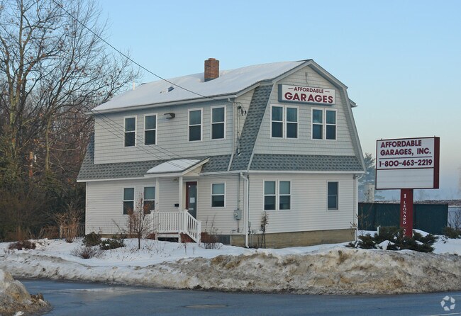
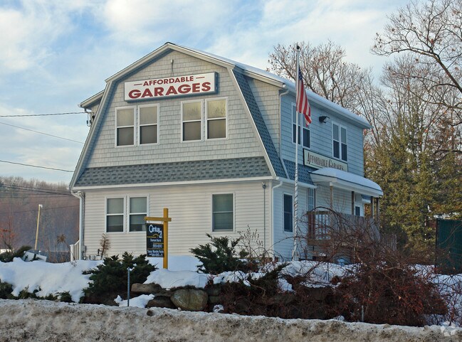
Property Record
1 Leonard Ave, Hooksett, NH 03106

Property Detail
1 Leonard Ave
Officebuilding
Merrimack
PZ
New Hampshire
B and X Area of moderate flood hazard, usually the area between the limits of the 100-year and 500-year floods.
0.16 AC
2024
Manchester/New Hampshire South Area
2024
Other Market Areas
003006
Concord, NH
1,600 SF
HOOK-000041-000000-000005
NEARBY LISTINGS FOR SALE OR LEASE
DEMOGRAPHICS near 1 Leonard Ave
1 mile
3 mile
5 mile
2025 Total Population
4,632
55,253
128,193
2030 Population
4,750
55,964
129,178
Pop Growth 2025-2030
+ 2.55%
+ 1.29%
+ 0.77%
Average Age
40
41
40
2025 Total Households
1,669
23,727
53,228
HH Growth 2025-2030
+ 2.82%
+ 1.38%
+ 0.83%
Median Household Inc
$111,395
$93,472
$86,028
Avg Household Size
2.50
2.20
2.20
2025 Avg HH Vehicles
2.00
2.00
2.00
Median Home Value
$423,198
$406,902
$375,958
Median Year Built
1979
1976
1969
Nearby Places
Map Layers
Map Styles
 Street
 Aerial
Transit
 Traffic
 Biking
Places
Listings with unknown addresses are not visible on the map
- Restaurants
- Banks
- Shops
- Fitness
- Groceries
PUBLIC TRANSPORTATION
AIRPORT
Manchester Boston Regional
Drive
Walk
Distance
Manchester Boston Regional
21 min
11.0 mi
Freight Ports
Port of Boston
Drive
Walk
Distance
Port of Boston
86 min
58.9 mi
SALE & LEASE HISTORY
LISTING DATE
SALE/LEASE

Feb 27, 2017
For Sale
Nearby Properties
Address
Land Use
TOTAL SIZE
Lot Size
Zoning
Address
Land Use
TOTAL SIZE
Lot Size
Zoning
26,232 SF
39.97 AC
Address
Land Use
TOTAL SIZE
Lot Size
Zoning
12.60 AC
PZ
Address
Land Use
TOTAL SIZE
Lot Size
Zoning
6,830 SF
17.24 AC
Address
Land Use
TOTAL SIZE
Lot Size
Zoning
135,686 SF
30.23 AC
Address
Land Use
TOTAL SIZE
Lot Size
Zoning
36,070 SF
141.66 AC
MUD4
Address
Land Use
TOTAL SIZE
Lot Size
Zoning
250,905 SF
1.16 AC
Address
Land Use
TOTAL SIZE
Lot Size
Zoning
229,089 SF
3.58 AC
Address
Land Use
TOTAL SIZE
Lot Size
Zoning
26,125 SF
150.66 AC
Address
Land Use
TOTAL SIZE
Lot Size
Zoning
143,630 SF
57.86 AC
Address
Land Use
TOTAL SIZE
Lot Size
Zoning
16,464 SF
15.19 AC
Address
Land Use
TOTAL SIZE
Lot Size
Zoning
237,634 SF
5.39 AC
Address
Land Use
TOTAL SIZE
Lot Size
Zoning
24,064 SF
19.44 AC
Address
Land Use
TOTAL SIZE
Lot Size
Zoning
16,000 SF
58.17 AC
Address
Land Use
TOTAL SIZE
Lot Size
Zoning
51.32 AC
MUD4
Address
Land Use
TOTAL SIZE
Lot Size
Zoning
211,525 SF
93.01 AC
Address
Land Use
TOTAL SIZE
Lot Size
Zoning
181,610 SF
0.58 AC
Address
Land Use
TOTAL SIZE
Lot Size
Zoning
154,363 SF
17.25 AC
MUD3
Address
Land Use
TOTAL SIZE
Lot Size
Zoning
264,671 SF
4.04 AC
Address
Land Use
TOTAL SIZE
Lot Size
Zoning
4,400 SF
76.15 AC
MUD4
Address
Land Use
TOTAL SIZE
Lot Size
Zoning
206,478 SF
3.91 AC
Address
Land Use
TOTAL SIZE
Lot Size
Zoning
1,998 SF
72.09 AC
MDR
Address
Land Use
TOTAL SIZE
Lot Size
Zoning
44,301 SF
71.24 AC
Address
Land Use
TOTAL SIZE
Lot Size
Zoning
Address
Land Use
TOTAL SIZE
Lot Size
Zoning
27,450 SF
9.10 AC
Address
Land Use
TOTAL SIZE
Lot Size
Zoning
131,003 SF
49.31 AC
Address
Land Use
TOTAL SIZE
Lot Size
Zoning
28,888 SF
5.50 AC
Address
Land Use
TOTAL SIZE
Lot Size
Zoning
367,086 SF
3.65 AC
Address
Land Use
TOTAL SIZE
Lot Size
Zoning
41,252 SF
6.87 AC
Address
Land Use
TOTAL SIZE
Lot Size
Zoning
107,144 SF
8.75 AC
Address
Land Use
TOTAL SIZE
Lot Size
Zoning
82,670 SF
27.76 AC
PZ
The World's #1 Commercial Real Estate Marketplace
Connect with us
© 2026 CoStar Group
The information above has been obtained from sources believed reliable. While we do not doubt its accuracy we have not verified it and make no guarantee, warranty or representation about it. It is your responsibility to independently confirm its accuracy and completeness. Any projections, opinions, assumptions, or estimates used are for example only and do not represent the current or future performance of the property. The value of this transaction to you depends on tax and other factors which should be evaluated by your tax, financial, and legal advisors. You and your advisors should conduct a careful, independent investigation of the property to determine to your satisfaction the suitability of the property for your needs.