Property Record
1 Lone Pine Dr, Berkeley Heights, NJ 07922
NEARBY LISTINGS FOR SALE OR LEASE
-
-
View all Berkeley Heights listings for sale on LoopNet.com
Property Detail
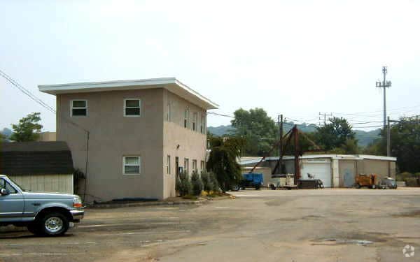
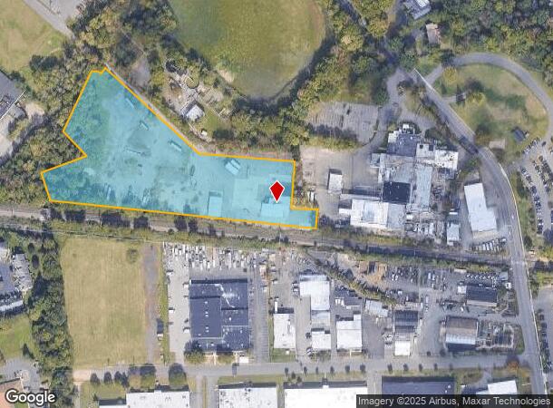
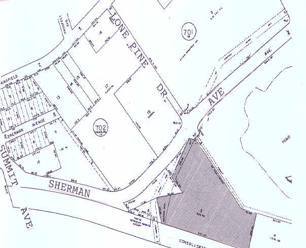
1 Lone Pine Dr
Newark, NJ-PA
Altansps Land Title Surv
01-00703-0000-00004
FACILITY NAME: IN-LIEU TAX PAYMENT
Taxexempt
Union
X
New Jersey
34035C0091E
4
2024
5.26 AC
2025
Route 78 East
038202
Northern New Jersey
DEMOGRAPHICS near 1 Lone Pine Dr
1 Mile
3 Mile
5 Mile
2024 Total Population
8,345
44,962
184,700
2029 Population
8,437
44,899
183,542
Pop Growth 2024-2029
+ 1.10%
(0.14%)
(0.63%)
Average Age
42
42
40
2024 Total Households
2,870
15,658
62,419
HH Growth 2024-2029
+ 0.94%
(0.35%)
(0.73%)
Median Household Inc
$148,791
$165,925
$133,913
Avg Household Size
2.80
2.80
2.90
2024 Avg HH Vehicles
2.00
2.00
2.00
Median Home Value
$707,736
$718,185
$699,362
Median Year Built
1968
1964
1958
Nearby Places
Map Layers
Map Styles
 Street
 Aerial
- Restaurants
- Banks
- Shops
- Fitness
- Groceries
PUBLIC TRANSPORTATION
COMMUTER RAIL
Berkeley Heights (Morris & Essex Gladstone Branch - NJ Transit Commuter Rail (NJ Transit))
DRIVE
WALK
Distance
Berkeley Heights (Morris & Essex Gladstone Branch - NJ Transit Commuter Rail (NJ Transit))
5 min
1.3 mi
Gillette (Morris & Essex Gladstone Branch - NJ Transit Commuter Rail (NJ Transit))
DRIVE
WALK
Distance
Gillette (Morris & Essex Gladstone Branch - NJ Transit Commuter Rail (NJ Transit))
8 min
2.9 mi
AIRPORT
Newark Liberty International
DRIVE
WALK
Distance
Newark Liberty International
26 min
18.3 mi
Freight Ports
New York Container Terminal
DRIVE
WALK
Distance
New York Container Terminal
36 min
21.2 mi
Nearby Properties
Address
Land Use
TOTAL SIZE
Lot Size
Zoning
Address
Land Use
TOTAL SIZE
Lot Size
Zoning
151,088 SF
26.48 AC
CCRC
Address
Land Use
TOTAL SIZE
Lot Size
Zoning
153.40 AC
OR
Address
Land Use
TOTAL SIZE
Lot Size
Zoning
439.33 AC
Address
Land Use
TOTAL SIZE
Lot Size
Zoning
0.42 AC
R-1
Address
Land Use
TOTAL SIZE
Lot Size
Zoning
26.87 AC
H-D
Address
Land Use
TOTAL SIZE
Lot Size
Zoning
47.69 AC
MU
Address
Land Use
TOTAL SIZE
Lot Size
Zoning
47.80 AC
H-D
Address
Land Use
TOTAL SIZE
Lot Size
Zoning
34.60 AC
MU
Address
Land Use
TOTAL SIZE
Lot Size
Zoning
140,732 SF
42.73 AC
OR
Address
Land Use
TOTAL SIZE
Lot Size
Zoning
23.93 AC
B2
Address
Land Use
TOTAL SIZE
Lot Size
Zoning
15.79 AC
H-D
Address
Land Use
TOTAL SIZE
Lot Size
Zoning
24.92 AC
MU
Address
Land Use
TOTAL SIZE
Lot Size
Zoning
12.47 AC
H-D
Address
Land Use
TOTAL SIZE
Lot Size
Zoning
61,912 SF
16 AC
OR
Address
Land Use
TOTAL SIZE
Lot Size
Zoning
23.66 AC
R2
Address
Land Use
TOTAL SIZE
Lot Size
Zoning
356.94 AC
OL
Address
Land Use
TOTAL SIZE
Lot Size
Zoning
21.53 AC
H-D
Address
Land Use
TOTAL SIZE
Lot Size
Zoning
36.55 AC
OL
Address
Land Use
TOTAL SIZE
Lot Size
Zoning
122,820 SF
14.65 AC
H-D
Address
Land Use
TOTAL SIZE
Lot Size
Zoning
184,000 SF
24.43 AC
OR
Address
Land Use
TOTAL SIZE
Lot Size
Zoning
12.52 AC
H-D
Address
Land Use
TOTAL SIZE
Lot Size
Zoning
6.76 AC
MU
Address
Land Use
TOTAL SIZE
Lot Size
Zoning
3,612 SF
7.92 AC
C
Address
Land Use
TOTAL SIZE
Lot Size
Zoning
16.30 AC
OR
Address
Land Use
TOTAL SIZE
Lot Size
Zoning
34.89 AC
R-1
Address
Land Use
TOTAL SIZE
Lot Size
Zoning
218,207 SF
15.28 AC
Address
Land Use
TOTAL SIZE
Lot Size
Zoning
57,710 SF
5.85 AC
H-D
Address
Land Use
TOTAL SIZE
Lot Size
Zoning
35.20 AC
OL
Address
Land Use
TOTAL SIZE
Lot Size
Zoning
9.53 AC
DD
Address
Land Use
TOTAL SIZE
Lot Size
Zoning
5.67 AC
H-D
The World's #1 Commercial Real Estate Marketplace
Connect with us
© 2025 CoStar Group
The information above has been obtained from sources believed reliable. While we do not doubt its accuracy we have not verified it and make no guarantee, warranty or representation about it. It is your responsibility to independently confirm its accuracy and completeness. Any projections, opinions, assumptions, or estimates used are for example only and do not represent the current or future performance of the property. The value of this transaction to you depends on tax and other factors which should be evaluated by your tax, financial, and legal advisors. You and your advisors should conduct a careful, independent investigation of the property to determine to your satisfaction the suitability of the property for your needs.