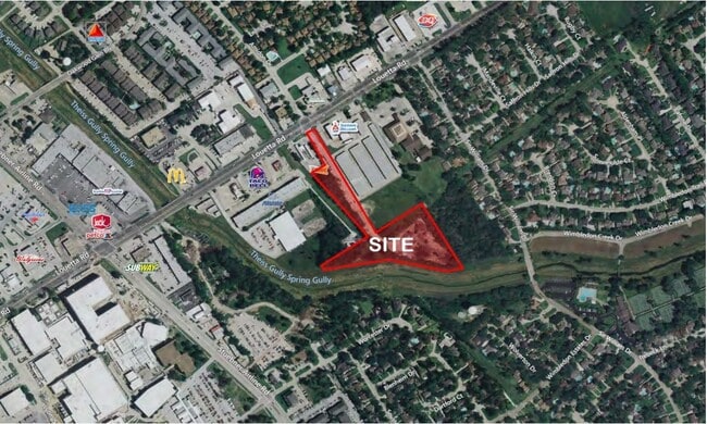
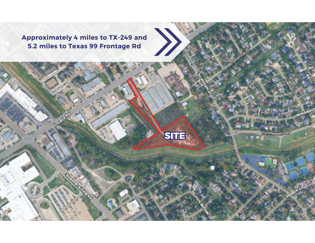
Property Record
1 Louetta Rd, Spring, TX 77379
Property Detail
1 Louetta Rd
Houston-Pasadena-The Woodlands, TX
RES A1 BLK 1 TONYA ONE
1175630010002
HARRIS
Commercialacreage
Texas
B and X Area of moderate flood hazard, usually the area between the limits of the 100-year and 500-year floods.
0.57 AC
2023
FM 1960/Champions
2025
Houston
553804
NEARBY LISTINGS FOR SALE OR LEASE
DEMOGRAPHICS near 1 Louetta Rd
1 mile
3 mile
5 mile
2025 Total Population
12,734
104,948
309,708
2030 Population
13,482
111,585
329,857
Pop Growth 2025-2030
+ 5.87%
+ 6.32%
+ 6.51%
Average Age
38
40
38
2025 Total Households
4,277
37,932
109,169
HH Growth 2025-2030
+ 6.06%
+ 6.53%
+ 6.71%
Median Household Inc
$80,822
$93,382
$84,341
Avg Household Size
2.90
2.70
2.80
2025 Avg HH Vehicles
2.00
2.00
2.00
Median Home Value
$331,101
$339,078
$310,373
Median Year Built
1984
1989
1996
Nearby Places
Map Layers
Map Styles
 Street
 Aerial
Transit
 Traffic
 Biking
Places
Listings with unknown addresses are not visible on the map
- Restaurants
- Banks
- Shops
- Fitness
- Groceries
PUBLIC TRANSPORTATION
AIRPORT
George Bush Intcntl/Houston
Drive
Walk
Distance
George Bush Intcntl/Houston
27 min
18.0 mi
William P Hobby
Drive
Walk
Distance
William P Hobby
55 min
33.6 mi
Freight Ports
Port of Houston
Drive
Walk
Distance
Port of Houston
47 min
29.2 mi
SALE & LEASE HISTORY
LISTING DATE
SALE/LEASE

Sep 24, 2016
For Sale
Aug 24, 2023
For Lease
Aug 24, 2023
For Sale
Nearby Properties
Address
Land Use
TOTAL SIZE
Lot Size
Zoning
Address
Land Use
TOTAL SIZE
Lot Size
Zoning
341,895 SF
17.53 AC
Address
Land Use
TOTAL SIZE
Lot Size
Zoning
507,035 SF
24.90 AC
Address
Land Use
TOTAL SIZE
Lot Size
Zoning
394,700 SF
17.34 AC
Address
Land Use
TOTAL SIZE
Lot Size
Zoning
286,090 SF
13.25 AC
Address
Land Use
TOTAL SIZE
Lot Size
Zoning
486,739 SF
19.92 AC
Address
Land Use
TOTAL SIZE
Lot Size
Zoning
262,163 SF
8.63 AC
Address
Land Use
TOTAL SIZE
Lot Size
Zoning
413,131 SF
12.52 AC
Address
Land Use
TOTAL SIZE
Lot Size
Zoning
256,761 SF
8.78 AC
Address
Land Use
TOTAL SIZE
Lot Size
Zoning
267,082 SF
11.13 AC
Address
Land Use
TOTAL SIZE
Lot Size
Zoning
80,004 SF
4.41 AC
Address
Land Use
TOTAL SIZE
Lot Size
Zoning
348,658 SF
16.72 AC
Address
Land Use
TOTAL SIZE
Lot Size
Zoning
148,450 SF
18.26 AC
Address
Land Use
TOTAL SIZE
Lot Size
Zoning
335,106 SF
13.27 AC
Address
Land Use
TOTAL SIZE
Lot Size
Zoning
304,518 SF
15 AC
Address
Land Use
TOTAL SIZE
Lot Size
Zoning
297,961 SF
18.04 AC
Address
Land Use
TOTAL SIZE
Lot Size
Zoning
173,371 SF
5.17 AC
Address
Land Use
TOTAL SIZE
Lot Size
Zoning
222,479 SF
4.82 AC
Address
Land Use
TOTAL SIZE
Lot Size
Zoning
130,470 SF
9.22 AC
Address
Land Use
TOTAL SIZE
Lot Size
Zoning
237,292 SF
11.91 AC
Address
Land Use
TOTAL SIZE
Lot Size
Zoning
247,670 SF
13.38 AC
Address
Land Use
TOTAL SIZE
Lot Size
Zoning
218,967 SF
14.11 AC
Address
Land Use
TOTAL SIZE
Lot Size
Zoning
145,051 SF
6.10 AC
Address
Land Use
TOTAL SIZE
Lot Size
Zoning
214,862 SF
14.92 AC
Address
Land Use
TOTAL SIZE
Lot Size
Zoning
221,352 SF
17.35 AC
Address
Land Use
TOTAL SIZE
Lot Size
Zoning
205,054 SF
10.05 AC
Address
Land Use
TOTAL SIZE
Lot Size
Zoning
204,633 SF
10.44 AC
Address
Land Use
TOTAL SIZE
Lot Size
Zoning
224,669 SF
15.40 AC
Address
Land Use
TOTAL SIZE
Lot Size
Zoning
286,341 SF
10.35 AC
Address
Land Use
TOTAL SIZE
Lot Size
Zoning
215,133 SF
9.26 AC
Address
Land Use
TOTAL SIZE
Lot Size
Zoning
202,323 SF
9.37 AC
The World's #1 Commercial Real Estate Marketplace
Connect with us
© 2026 CoStar Group
The information above has been obtained from sources believed reliable. While we do not doubt its accuracy we have not verified it and make no guarantee, warranty or representation about it. It is your responsibility to independently confirm its accuracy and completeness. Any projections, opinions, assumptions, or estimates used are for example only and do not represent the current or future performance of the property. The value of this transaction to you depends on tax and other factors which should be evaluated by your tax, financial, and legal advisors. You and your advisors should conduct a careful, independent investigation of the property to determine to your satisfaction the suitability of the property for your needs.