Property Record
1 Main St, Burlington, VT 05401


Property Detail
1 Main St
Burlington-South Burlington, VT
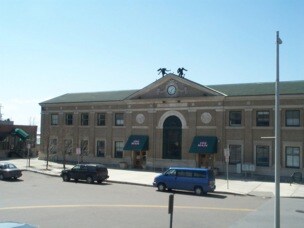
UNION STATION/CORNERSTONE/WING
114-035-16985
Chittenden
Commercialnec
Vermont
DWPT
2.70 AC
2021
Downtown Burlington
2021
Other Market Areas
0010001017
NEARBY LISTINGS FOR SALE OR LEASE
DEMOGRAPHICS near 1 Main St
1 mile
3 mile
5 mile
2025 Total Population
18,797
57,936
89,337
2030 Population
18,823
58,302
90,190
Pop Growth 2025-2030
+ 0.14%
+ 0.63%
+ 0.95%
Average Age
34
36
38
2025 Total Households
8,423
24,296
36,949
HH Growth 2025-2030
+ 0.30%
+ 0.71%
+ 1.07%
Median Household Inc
$60,851
$78,387
$89,232
Avg Household Size
2.00
2.10
2.10
2025 Avg HH Vehicles
1.00
1.00
2.00
Median Home Value
$546,223
$430,484
$428,244
Median Year Built
1948
1966
1975
Nearby Places
Map Layers
Map Styles
 Street
 Aerial
Transit
 Traffic
 Biking
Places
Listings with unknown addresses are not visible on the map
- Restaurants
- Banks
- Shops
- Fitness
- Groceries
PUBLIC TRANSPORTATION
COMMUTER RAIL
Burlington (Ethan Allen Express - Amtrak)
Drive
Walk
Distance
Burlington (Ethan Allen Express - Amtrak)
1 min
0 min
0.0 mi
Essex Junction-Burlington Amtrak Station (Vermonter - Amtrak)
Drive
Walk
Distance
Essex Junction-Burlington Amtrak Station (Vermonter - Amtrak)
18 min
7.8 mi
AIRPORT
Patrick Leahy Burlington International
Drive
Walk
Distance
Patrick Leahy Burlington International
18 min
6.4 mi
Plattsburgh International
Drive
Walk
Distance
Plattsburgh International
70 min
34.5 mi
Freight Ports
Montreal
Drive
Walk
Distance
Montreal
129 min
97.8 mi
SALE & LEASE HISTORY
LISTING DATE
SALE/LEASE

Mar 30, 2021
For Lease
Nearby Properties
Address
Land Use
TOTAL SIZE
Lot Size
Zoning
Address
Land Use
TOTAL SIZE
Lot Size
Zoning
2,542,351 SF
34.82 AC
I
Address
Land Use
TOTAL SIZE
Lot Size
Zoning
Address
Land Use
TOTAL SIZE
Lot Size
Zoning
168,175 SF
I
Address
Land Use
TOTAL SIZE
Lot Size
Zoning
2.96 AC
I
Address
Land Use
TOTAL SIZE
Lot Size
Zoning
12.26 AC
I
Address
Land Use
TOTAL SIZE
Lot Size
Zoning
Address
Land Use
TOTAL SIZE
Lot Size
Zoning
27.70 AC
Address
Land Use
TOTAL SIZE
Lot Size
Zoning
232,277 SF
17.20 AC
I
Address
Land Use
TOTAL SIZE
Lot Size
Zoning
Address
Land Use
TOTAL SIZE
Lot Size
Zoning
167,016 SF
2.30 AC
I
Address
Land Use
TOTAL SIZE
Lot Size
Zoning
32.43 AC
I
Address
Land Use
TOTAL SIZE
Lot Size
Zoning
1.70 AC
FD6
Address
Land Use
TOTAL SIZE
Lot Size
Zoning
19.86 AC
I
Address
Land Use
TOTAL SIZE
Lot Size
Zoning
Address
Land Use
TOTAL SIZE
Lot Size
Zoning
98,123 SF
I
Address
Land Use
TOTAL SIZE
Lot Size
Zoning
20.87 AC
RL
Address
Land Use
TOTAL SIZE
Lot Size
Zoning
Address
Land Use
TOTAL SIZE
Lot Size
Zoning
157,081 SF
I
Address
Land Use
TOTAL SIZE
Lot Size
Zoning
1.16 AC
FD6
Address
Land Use
TOTAL SIZE
Lot Size
Zoning
181,068 SF
I
Address
Land Use
TOTAL SIZE
Lot Size
Zoning
140,910 SF
2.72 AC
I
Address
Land Use
TOTAL SIZE
Lot Size
Zoning
2.06 AC
FD6
Address
Land Use
TOTAL SIZE
Lot Size
Zoning
11.82 AC
ELM
Address
Land Use
TOTAL SIZE
Lot Size
Zoning
Address
Land Use
TOTAL SIZE
Lot Size
Zoning
6.50 AC
I
Address
Land Use
TOTAL SIZE
Lot Size
Zoning
68,321 SF
4.60 AC
I
Address
Land Use
TOTAL SIZE
Lot Size
Zoning
Address
Land Use
TOTAL SIZE
Lot Size
Zoning
119,561 SF
1.86 AC
FD5
Address
Land Use
TOTAL SIZE
Lot Size
Zoning
8,680 SF
45.56 AC
EAE
Address
Land Use
TOTAL SIZE
Lot Size
Zoning
140.43 AC
I
The World's #1 Commercial Real Estate Marketplace
Connect with us
© 2026 CoStar Group
The information above has been obtained from sources believed reliable. While we do not doubt its accuracy we have not verified it and make no guarantee, warranty or representation about it. It is your responsibility to independently confirm its accuracy and completeness. Any projections, opinions, assumptions, or estimates used are for example only and do not represent the current or future performance of the property. The value of this transaction to you depends on tax and other factors which should be evaluated by your tax, financial, and legal advisors. You and your advisors should conduct a careful, independent investigation of the property to determine to your satisfaction the suitability of the property for your needs.