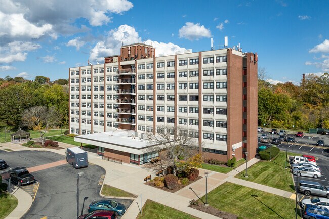
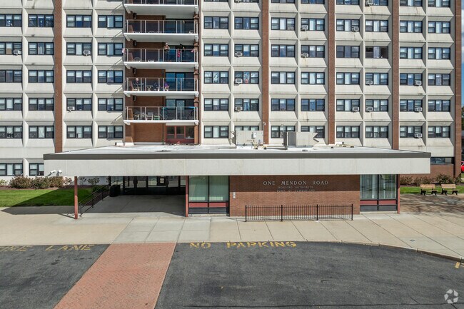
Property Record
1 Mendon Rd, Cumberland, RI 02864

Property Detail
1 Mendon Rd
CUMB-000012-000006-000000
Providence
Governmentalpublicusegeneral
Rhode Island
120
6 AC
AE The base floodplain where base flood elevations are provided. AE Zones are now used on new format FIRMs instead of A1-A30 Zones.
Northeastern Providence County
0
Providence
2025
Providence-Warwick, RI-MA
011200
NEARBY LISTINGS FOR SALE OR LEASE
-
-
View all Cumberland listings for sale on LoopNet.com
DEMOGRAPHICS near 1 Mendon Rd
1 mile
3 mile
5 mile
2025 Total Population
12,910
101,178
226,689
2030 Population
13,229
103,585
233,150
Pop Growth 2025-2030
+ 2.47%
+ 2.38%
+ 2.85%
Average Age
42
39
41
2025 Total Households
5,318
39,697
91,243
HH Growth 2025-2030
+ 2.43%
+ 2.42%
+ 2.89%
Median Household Inc
$79,987
$72,450
$79,119
Avg Household Size
2.40
2.50
2.40
2025 Avg HH Vehicles
2.00
2.00
2.00
Median Home Value
$374,477
$383,060
$389,524
Median Year Built
1958
1956
1959
Nearby Places
Map Layers
Map Styles
 Street
 Aerial
Transit
 Traffic
 Biking
Places
Listings with unknown addresses are not visible on the map
- Restaurants
- Banks
- Shops
- Fitness
- Groceries
PUBLIC TRANSPORTATION
COMMUTER RAIL
Drive
Walk
Distance
6 min
3.4 mi
South Attleboro (Providence/Stoughton Line - Massachusetts Bay Transportation Authority Commuter Rail (Purple Line))
Drive
Walk
Distance
South Attleboro (Providence/Stoughton Line - Massachusetts Bay Transportation Authority Commuter Rail (Purple Line))
9 min
4.8 mi
AIRPORT
Rhode Island Tf Green International
Drive
Walk
Distance
Rhode Island Tf Green International
28 min
15.9 mi
Worcester Regional
Drive
Walk
Distance
Worcester Regional
54 min
39.2 mi
General Edward Lawrence Logan International
Drive
Walk
Distance
General Edward Lawrence Logan International
65 min
47.9 mi
Freight Ports
Port of Davisville, RI
Drive
Walk
Distance
Port of Davisville, RI
44 min
28.3 mi
Nearby Properties
Address
Land Use
TOTAL SIZE
Lot Size
Zoning
Address
Land Use
TOTAL SIZE
Lot Size
Zoning
170,531 SF
3 AC
M-2
Address
Land Use
TOTAL SIZE
Lot Size
Zoning
200.05 AC
RA40
Address
Land Use
TOTAL SIZE
Lot Size
Zoning
41.01 AC
30
Address
Land Use
TOTAL SIZE
Lot Size
Zoning
38.50 AC
RA40
Address
Land Use
TOTAL SIZE
Lot Size
Zoning
54.49 AC
RS20
Address
Land Use
TOTAL SIZE
Lot Size
Zoning
4.60 AC
60
Address
Land Use
TOTAL SIZE
Lot Size
Zoning
14,841 SF
15.70 AC
PHB
Address
Land Use
TOTAL SIZE
Lot Size
Zoning
10,920 SF
11.03 AC
Address
Land Use
TOTAL SIZE
Lot Size
Zoning
341,251 SF
16.22 AC
60
Address
Land Use
TOTAL SIZE
Lot Size
Zoning
147,170 SF
2.23 AC
R-3
Address
Land Use
TOTAL SIZE
Lot Size
Zoning
15,086 SF
2.61 AC
C-2
Address
Land Use
TOTAL SIZE
Lot Size
Zoning
115,258 SF
10.08 AC
100
Address
Land Use
TOTAL SIZE
Lot Size
Zoning
97,858 SF
2.02 AC
R-3
Address
Land Use
TOTAL SIZE
Lot Size
Zoning
98,968 SF
1.66 AC
R-2
Address
Land Use
TOTAL SIZE
Lot Size
Zoning
119,776 SF
17.33 AC
ML05
Address
Land Use
TOTAL SIZE
Lot Size
Zoning
155,731 SF
41.03 AC
PHB
Address
Land Use
TOTAL SIZE
Lot Size
Zoning
2.23 AC
RE
Address
Land Use
TOTAL SIZE
Lot Size
Zoning
69,053 SF
0.87 AC
C-2
Address
Land Use
TOTAL SIZE
Lot Size
Zoning
27,264 SF
6.20 AC
Address
Land Use
TOTAL SIZE
Lot Size
Zoning
100,019 SF
10.37 AC
120
Address
Land Use
TOTAL SIZE
Lot Size
Zoning
105,384 SF
17.07 AC
120
Address
Land Use
TOTAL SIZE
Lot Size
Zoning
39,994 SF
4.03 AC
40
Address
Land Use
TOTAL SIZE
Lot Size
Zoning
116,540 SF
9.70 AC
PHB
Address
Land Use
TOTAL SIZE
Lot Size
Zoning
1.73 AC
R-3
Address
Land Use
TOTAL SIZE
Lot Size
Zoning
48,216 SF
9.01 AC
ML05
Address
Land Use
TOTAL SIZE
Lot Size
Zoning
4.54 AC
M-1
Address
Land Use
TOTAL SIZE
Lot Size
Zoning
45,074 SF
1.28 AC
R-3
Address
Land Use
TOTAL SIZE
Lot Size
Zoning
475,344 SF
25.49 AC
MG05
Address
Land Use
TOTAL SIZE
Lot Size
Zoning
121,186 SF
1.86 AC
R-3
The World's #1 Commercial Real Estate Marketplace
Connect with us
© 2026 CoStar Group
The information above has been obtained from sources believed reliable. While we do not doubt its accuracy we have not verified it and make no guarantee, warranty or representation about it. It is your responsibility to independently confirm its accuracy and completeness. Any projections, opinions, assumptions, or estimates used are for example only and do not represent the current or future performance of the property. The value of this transaction to you depends on tax and other factors which should be evaluated by your tax, financial, and legal advisors. You and your advisors should conduct a careful, independent investigation of the property to determine to your satisfaction the suitability of the property for your needs.