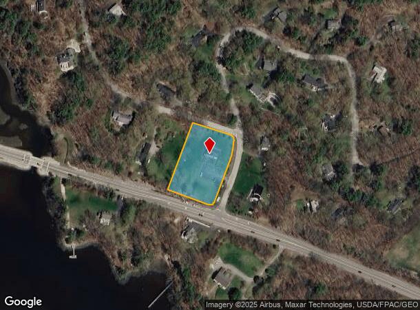
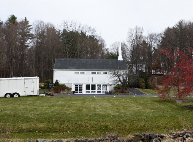
Property Record
1 Morgan Way, Durham, NH 03824

NEARBY LISTINGS FOR SALE OR LEASE
Property Detail
1 Morgan Way
DRHM-000011-000023-000001
Strafford
Taxexempt
New Hampshire
X
1
33017C0320E
1.40 AC
0
Strafford County
2024
Boston
080202
Boston-Cambridge-Newton, MA-NH
2,754 SF
DEMOGRAPHICS near 1 Morgan Way
1 mile
3 mile
5 mile
2024 Total Population
662
18,118
51,365
2029 Population
709
18,976
53,764
Pop Growth 2024-2029
+ 7.10%
+ 4.74%
+ 4.67%
Average Age
44
38
38
2024 Total Households
234
6,106
19,832
HH Growth 2024-2029
+ 7.69%
+ 5.40%
+ 5.18%
Median Household Inc
$136,875
$124,908
$101,083
Avg Household Size
2.60
2.40
2.20
2024 Avg HH Vehicles
2.00
2.00
2.00
Median Home Value
$499,999
$404,981
$409,809
Median Year Built
1977
1980
1976
Nearby Places
Map Layers
Map Styles
 Street
 Aerial
Transit
 Traffic
 Biking
Places
Listings with unknown addresses are not visible on the map
- Restaurants
- Banks
- Shops
- Fitness
- Groceries
PUBLIC TRANSPORTATION
COMMUTER RAIL
Drive
Walk
Distance
8 min
3.3 mi
Drive
Walk
Distance
15 min
6.6 mi
AIRPORT
Portsmouth International at Pease
Drive
Walk
Distance
Portsmouth International at Pease
13 min
6.7 mi
Manchester Boston Regional
Drive
Walk
Distance
Manchester Boston Regional
64 min
43.3 mi
Nearby Properties
Address
Land Use
TOTAL SIZE
Lot Size
Zoning
Address
Land Use
TOTAL SIZE
Lot Size
Zoning
25.04 AC
RA
Address
Land Use
TOTAL SIZE
Lot Size
Zoning
389 AC
MUDOR
Address
Land Use
TOTAL SIZE
Lot Size
Zoning
358 AC
MUDOR
Address
Land Use
TOTAL SIZE
Lot Size
Zoning
355,634 SF
11.29 AC
OR
Address
Land Use
TOTAL SIZE
Lot Size
Zoning
6.30 AC
CB
Address
Land Use
TOTAL SIZE
Lot Size
Zoning
2.61 AC
CB
Address
Land Use
TOTAL SIZE
Lot Size
Zoning
39 AC
RA
Address
Land Use
TOTAL SIZE
Lot Size
Zoning
19.67 AC
RA
Address
Land Use
TOTAL SIZE
Lot Size
Zoning
1.10 AC
CB
Address
Land Use
TOTAL SIZE
Lot Size
Zoning
26.40 AC
IT*
Address
Land Use
TOTAL SIZE
Lot Size
Zoning
60.41 AC
R-40
Address
Land Use
TOTAL SIZE
Lot Size
Zoning
7.92 AC
R-12
Address
Land Use
TOTAL SIZE
Lot Size
Zoning
Address
Land Use
TOTAL SIZE
Lot Size
Zoning
11.47 AC
IT
Address
Land Use
TOTAL SIZE
Lot Size
Zoning
31 AC
MUDOR
Address
Land Use
TOTAL SIZE
Lot Size
Zoning
11 AC
R-20
Address
Land Use
TOTAL SIZE
Lot Size
Zoning
25 AC
ORLI
Address
Land Use
TOTAL SIZE
Lot Size
Zoning
57.28 AC
IT
Address
Land Use
TOTAL SIZE
Lot Size
Zoning
63,886 SF
2.74 AC
PO
Address
Land Use
TOTAL SIZE
Lot Size
Zoning
19 AC
RM-SU
Address
Land Use
TOTAL SIZE
Lot Size
Zoning
Address
Land Use
TOTAL SIZE
Lot Size
Zoning
57.28 AC
IT
Address
Land Use
TOTAL SIZE
Lot Size
Zoning
30.77 AC
MR
Address
Land Use
TOTAL SIZE
Lot Size
Zoning
28.40 AC
DBP
Address
Land Use
TOTAL SIZE
Lot Size
Zoning
30,183 SF
10.66 AC
CB
Address
Land Use
TOTAL SIZE
Lot Size
Zoning
3.31 AC
C*
Address
Land Use
TOTAL SIZE
Lot Size
Zoning
24,308 SF
1.30 AC
PO
Address
Land Use
TOTAL SIZE
Lot Size
Zoning
31,625 SF
0.36 AC
CB
Address
Land Use
TOTAL SIZE
Lot Size
Zoning
16 AC
DBP
Address
Land Use
TOTAL SIZE
Lot Size
Zoning
2,704 SF
0.44 AC
CB
The World's #1 Commercial Real Estate Marketplace
Connect with us
© 2026 CoStar Group
The information above has been obtained from sources believed reliable. While we do not doubt its accuracy we have not verified it and make no guarantee, warranty or representation about it. It is your responsibility to independently confirm its accuracy and completeness. Any projections, opinions, assumptions, or estimates used are for example only and do not represent the current or future performance of the property. The value of this transaction to you depends on tax and other factors which should be evaluated by your tax, financial, and legal advisors. You and your advisors should conduct a careful, independent investigation of the property to determine to your satisfaction the suitability of the property for your needs.