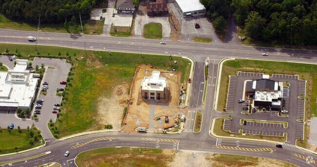
Property Record
1 Mt Laurel Ave, Birmingham, AL 35242
NEARBY LISTINGS FOR SALE OR LEASE
Property Detail
1 Mt Laurel Ave
Birmingham-Hoover, AL
Tattersall Park Resurvey No 9 Tattersall
03-9-32-0-001-006-000
BEG E ROW HWY 119 & N LN SW1/4 E1600(S) SWLY846.2 SW647.2 W TO E ROW PROPOSED TATTERSALL BLVD NLY ALG ROW TO N LINE LOT 1 MB
Commercialacreage
Shelby
AE
Alabama
01117C0091E
10
2024
31.18 AC
2024
Hwy 280/Shelby County
030211
Birmingham
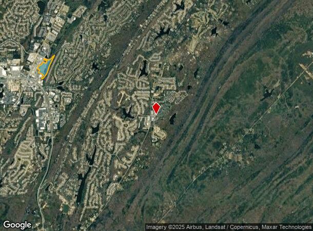
DEMOGRAPHICS near 1 Mt Laurel Ave
1 Mile
3 Mile
5 Mile
2024 Total Population
6,074
38,588
74,138
2029 Population
6,551
41,643
77,746
Pop Growth 2024-2029
+ 7.85%
+ 7.92%
+ 4.87%
Average Age
43
42
41
2024 Total Households
2,545
16,334
31,132
HH Growth 2024-2029
+ 8.02%
+ 7.96%
+ 4.76%
Median Household Inc
$107,628
$102,544
$105,198
Avg Household Size
2.40
2.30
2.30
2024 Avg HH Vehicles
2.00
2.00
2.00
Median Home Value
$448,944
$419,856
$401,854
Median Year Built
1994
1995
1995
Nearby Places
Map Layers
Map Styles
 Street
 Aerial
- Restaurants
- Banks
- Shops
- Fitness
- Groceries
PUBLIC TRANSPORTATION
AIRPORT
Birmingham-Shuttlesworth International
DRIVE
WALK
Distance
Birmingham-Shuttlesworth International
37 min
22.4 mi
Freight Ports
Port of Mobile
DRIVE
WALK
Distance
Port of Mobile
287 min
253.4 mi
Nearby Properties
Address
Land Use
TOTAL SIZE
Lot Size
Zoning
Address
Land Use
TOTAL SIZE
Lot Size
Zoning
37,950 SF
26.50 AC
Address
Land Use
TOTAL SIZE
Lot Size
Zoning
4,335 SF
26.43 AC
Address
Land Use
TOTAL SIZE
Lot Size
Zoning
64,375 SF
8.99 AC
Address
Land Use
TOTAL SIZE
Lot Size
Zoning
11,058 SF
24.33 AC
Address
Land Use
TOTAL SIZE
Lot Size
Zoning
111,045 SF
25.72 AC
Address
Land Use
TOTAL SIZE
Lot Size
Zoning
144,210 SF
9.37 AC
Address
Land Use
TOTAL SIZE
Lot Size
Zoning
4,259 SF
24.94 AC
Address
Land Use
TOTAL SIZE
Lot Size
Zoning
60,656 SF
20.32 AC
Address
Land Use
TOTAL SIZE
Lot Size
Zoning
220,128 SF
24.49 AC
Address
Land Use
TOTAL SIZE
Lot Size
Zoning
16,243 SF
10.74 AC
Address
Land Use
TOTAL SIZE
Lot Size
Zoning
2,220 SF
12.20 AC
Address
Land Use
TOTAL SIZE
Lot Size
Zoning
27,504 SF
14.05 AC
Address
Land Use
TOTAL SIZE
Lot Size
Zoning
19,954 SF
19.48 AC
Address
Land Use
TOTAL SIZE
Lot Size
Zoning
66,174 SF
28 AC
Address
Land Use
TOTAL SIZE
Lot Size
Zoning
1,436 SF
19.64 AC
Address
Land Use
TOTAL SIZE
Lot Size
Zoning
55,068 SF
23.03 AC
Address
Land Use
TOTAL SIZE
Lot Size
Zoning
99,535 SF
9.61 AC
Address
Land Use
TOTAL SIZE
Lot Size
Zoning
102,800 SF
12.38 AC
Address
Land Use
TOTAL SIZE
Lot Size
Zoning
52,068 SF
7.29 AC
Address
Land Use
TOTAL SIZE
Lot Size
Zoning
103,320 SF
18.47 AC
Address
Land Use
TOTAL SIZE
Lot Size
Zoning
102,387 SF
8.92 AC
Address
Land Use
TOTAL SIZE
Lot Size
Zoning
86,499 SF
14.55 AC
Address
Land Use
TOTAL SIZE
Lot Size
Zoning
11,058 SF
6.37 AC
Address
Land Use
TOTAL SIZE
Lot Size
Zoning
61,114 SF
2.54 AC
Address
Land Use
TOTAL SIZE
Lot Size
Zoning
97,899 SF
1.71 AC
Address
Land Use
TOTAL SIZE
Lot Size
Zoning
21,572 SF
4 AC
The World's #1 Commercial Real Estate Marketplace
Connect with us
© 2026 CoStar Group
The information above has been obtained from sources believed reliable. While we do not doubt its accuracy we have not verified it and make no guarantee, warranty or representation about it. It is your responsibility to independently confirm its accuracy and completeness. Any projections, opinions, assumptions, or estimates used are for example only and do not represent the current or future performance of the property. The value of this transaction to you depends on tax and other factors which should be evaluated by your tax, financial, and legal advisors. You and your advisors should conduct a careful, independent investigation of the property to determine to your satisfaction the suitability of the property for your needs.