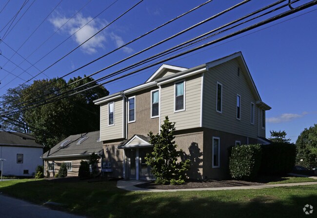
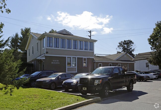
Property Record
1 N Bacton Hill Rd, Malvern, PA 19355


NEARBY LISTINGS FOR SALE OR LEASE
Property Detail
1 N Bacton Hill Rd
Philadelphia-Camden-Wilmington, PA-NJ-DE-MD
Watson & Mark Swanenburg
42-003-0082.0000
1.4 AC & OFF BLDG LOT 8
Officebuilding
Chester
X
Pennsylvania
42029C0155G
8
2024
1.40 AC
2025
Exton/Whitelands
302104
Philadelphia
20,394 SF
DEMOGRAPHICS near 1 N Bacton Hill Rd
1 Mile
3 Mile
5 Mile
2024 Total Population
3,589
36,472
98,073
2029 Population
3,770
38,345
103,394
Pop Growth 2024-2029
+ 5.04%
+ 5.14%
+ 5.43%
Average Age
37
42
42
2024 Total Households
1,179
13,423
37,230
HH Growth 2024-2029
+ 5.17%
+ 5.19%
+ 5.57%
Median Household Inc
$136,784
$131,262
$127,683
Avg Household Size
2.90
2.60
2.50
2024 Avg HH Vehicles
2.00
2.00
2.00
Median Home Value
$492,080
$475,388
$485,076
Median Year Built
2001
1986
1984
Nearby Places
Map Layers
Map Styles
 Street
 Aerial
- Restaurants
- Banks
- Shops
- Fitness
- Groceries
PUBLIC TRANSPORTATION
AIRPORT
Philadelphia International
DRIVE
WALK
Distance
Philadelphia International
49 min
27.7 mi
SALE & LEASE HISTORY
LISTING DATE
SALE/LEASE

Oct 10, 2016
For Lease
Nearby Properties
Address
Land Use
TOTAL SIZE
Lot Size
Zoning
Address
Land Use
TOTAL SIZE
Lot Size
Zoning
734,062 SF
150.80 AC
R1
Address
Land Use
TOTAL SIZE
Lot Size
Zoning
461,014 SF
70.50 AC
R1
Address
Land Use
TOTAL SIZE
Lot Size
Zoning
273,175 SF
20.46 AC
PO1
Address
Land Use
TOTAL SIZE
Lot Size
Zoning
29.92 AC
I1
Address
Land Use
TOTAL SIZE
Lot Size
Zoning
297,424 SF
5.11 AC
C4
Address
Land Use
TOTAL SIZE
Lot Size
Zoning
412,888 SF
44.75 AC
LI
Address
Land Use
TOTAL SIZE
Lot Size
Zoning
338,507 SF
2.08 AC
R2
Address
Land Use
TOTAL SIZE
Lot Size
Zoning
370,879 SF
21.60 AC
R1
Address
Land Use
TOTAL SIZE
Lot Size
Zoning
129,289 SF
4 AC
R1
Address
Land Use
TOTAL SIZE
Lot Size
Zoning
477,007 SF
55 AC
I1
Address
Land Use
TOTAL SIZE
Lot Size
Zoning
214,675 SF
22.50 AC
PO2
Address
Land Use
TOTAL SIZE
Lot Size
Zoning
267,843 SF
18.35 AC
R1
Address
Land Use
TOTAL SIZE
Lot Size
Zoning
474,486 SF
30 AC
R1
Address
Land Use
TOTAL SIZE
Lot Size
Zoning
272,675 SF
28.80 AC
TCM
Address
Land Use
TOTAL SIZE
Lot Size
Zoning
129,207 SF
13.24 AC
R2
Address
Land Use
TOTAL SIZE
Lot Size
Zoning
264,792 SF
23.50 AC
C3
Address
Land Use
TOTAL SIZE
Lot Size
Zoning
196,076 SF
14.04 AC
LI
Address
Land Use
TOTAL SIZE
Lot Size
Zoning
144,024 SF
10 AC
RIC
Address
Land Use
TOTAL SIZE
Lot Size
Zoning
291,349 SF
17.90 AC
LI
Address
Land Use
TOTAL SIZE
Lot Size
Zoning
200,275 SF
45.83 AC
LI
Address
Land Use
TOTAL SIZE
Lot Size
Zoning
184,309 SF
24.70 AC
C1
Address
Land Use
TOTAL SIZE
Lot Size
Zoning
140,834 SF
11.91 AC
TCM
Address
Land Use
TOTAL SIZE
Lot Size
Zoning
105,802 SF
10.90 AC
LI
Address
Land Use
TOTAL SIZE
Lot Size
Zoning
300,548 SF
83.60 AC
R1
Address
Land Use
TOTAL SIZE
Lot Size
Zoning
259,520 SF
15.70 AC
MHP
Address
Land Use
TOTAL SIZE
Lot Size
Zoning
68,563 SF
33.70 AC
I1
Address
Land Use
TOTAL SIZE
Lot Size
Zoning
160,586 SF
55.60 AC
R2
Address
Land Use
TOTAL SIZE
Lot Size
Zoning
100,896 SF
12.97 AC
LI
Address
Land Use
TOTAL SIZE
Lot Size
Zoning
217,100 SF
20.60 AC
R2
Address
Land Use
TOTAL SIZE
Lot Size
Zoning
192,780 SF
21.90 AC
PO1
The World's #1 Commercial Real Estate Marketplace
Connect with us
© 2025 CoStar Group
The information above has been obtained from sources believed reliable. While we do not doubt its accuracy we have not verified it and make no guarantee, warranty or representation about it. It is your responsibility to independently confirm its accuracy and completeness. Any projections, opinions, assumptions, or estimates used are for example only and do not represent the current or future performance of the property. The value of this transaction to you depends on tax and other factors which should be evaluated by your tax, financial, and legal advisors. You and your advisors should conduct a careful, independent investigation of the property to determine to your satisfaction the suitability of the property for your needs.