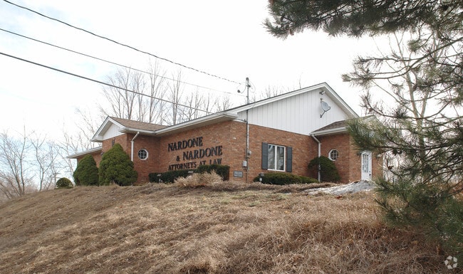
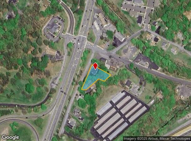
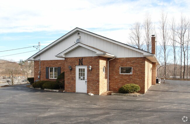
Property Record
1 N Roberts Rd, Highland, NY 12528

NEARBY LISTINGS FOR SALE OR LEASE
Property Detail
1 N Roberts Rd
Storesoffices
Ulster
X
New York
36027C0354E
28.000
2025
0.20 AC
2024
Other Market Areas
953600
Kingston, NY
2,318 SF
3200-096.001-0001-028.000-0000
DEMOGRAPHICS near 1 N Roberts Rd
1 Mile
3 Mile
5 Mile
2024 Total Population
4,415
42,765
81,222
2029 Population
4,416
42,677
81,189
Pop Growth 2024-2029
+ 0.02%
(0.21%)
(0.04%)
Average Age
44
39
40
2024 Total Households
1,778
16,116
30,900
HH Growth 2024-2029
0.00%
(0.12%)
+ 0.05%
Median Household Inc
$91,683
$56,543
$66,364
Avg Household Size
2.30
2.30
2.30
2024 Avg HH Vehicles
2.00
1.00
2.00
Median Home Value
$368,390
$269,326
$272,341
Median Year Built
1985
1957
1965
Nearby Places
- Restaurants
- Banks
- Shops
- Fitness
- Groceries
PUBLIC TRANSPORTATION
COMMUTER RAIL
Poughkeepsie Station (Hudson Line - Metro-North Commuter Railroad Company (Metro-North))
DRIVE
WALK
Distance
Poughkeepsie Station (Hudson Line - Metro-North Commuter Railroad Company (Metro-North))
9 min
3.1 mi
AIRPORT
New York Stewart International
DRIVE
WALK
Distance
New York Stewart International
31 min
21.6 mi
Nearby Properties
Address
Land Use
TOTAL SIZE
Lot Size
Zoning
Address
Land Use
TOTAL SIZE
Lot Size
Zoning
640,854 SF
21.22 AC
H-M
Address
Land Use
TOTAL SIZE
Lot Size
Zoning
314,927 SF
24.59 AC
IN
Address
Land Use
TOTAL SIZE
Lot Size
Zoning
4.99 AC
R2A
Address
Land Use
TOTAL SIZE
Lot Size
Zoning
488,904 SF
12.90 AC
R-3
Address
Land Use
TOTAL SIZE
Lot Size
Zoning
246,913 SF
43.93 AC
IN
Address
Land Use
TOTAL SIZE
Lot Size
Zoning
181,295 SF
20.48 AC
IN
Address
Land Use
TOTAL SIZE
Lot Size
Zoning
3 AC
R-D
Address
Land Use
TOTAL SIZE
Lot Size
Zoning
2.11 AC
IN
Address
Land Use
TOTAL SIZE
Lot Size
Zoning
4.49 AC
IH
Address
Land Use
TOTAL SIZE
Lot Size
Zoning
39.21 AC
R-1
Address
Land Use
TOTAL SIZE
Lot Size
Zoning
108,096 SF
2.50 AC
C-2
Address
Land Use
TOTAL SIZE
Lot Size
Zoning
317,644 SF
35.25 AC
CIA
Address
Land Use
TOTAL SIZE
Lot Size
Zoning
105,762 SF
2.41 AC
H-M
Address
Land Use
TOTAL SIZE
Lot Size
Zoning
5.29 AC
I-2
Address
Land Use
TOTAL SIZE
Lot Size
Zoning
4 AC
R-1
Address
Land Use
TOTAL SIZE
Lot Size
Zoning
296,400 SF
0.66 AC
C-2
Address
Land Use
TOTAL SIZE
Lot Size
Zoning
218,118 SF
13.15 AC
FC
Address
Land Use
TOTAL SIZE
Lot Size
Zoning
102,798 SF
16.71 AC
IN
Address
Land Use
TOTAL SIZE
Lot Size
Zoning
2.53 AC
R-D
Address
Land Use
TOTAL SIZE
Lot Size
Zoning
23,044 SF
12.60 AC
R-5
Address
Land Use
TOTAL SIZE
Lot Size
Zoning
103,108 SF
24.31 AC
HRDD
Address
Land Use
TOTAL SIZE
Lot Size
Zoning
82,739 SF
6.16 AC
IN
Address
Land Use
TOTAL SIZE
Lot Size
Zoning
59,499 SF
0.97 AC
IN
Address
Land Use
TOTAL SIZE
Lot Size
Zoning
55,299 SF
1.45 AC
C-1
Address
Land Use
TOTAL SIZE
Lot Size
Zoning
82,000 SF
1.27 AC
IN
Address
Land Use
TOTAL SIZE
Lot Size
Zoning
179,206 SF
8.19 AC
R-4
Address
Land Use
TOTAL SIZE
Lot Size
Zoning
297,663 SF
4.45 AC
H-M
Address
Land Use
TOTAL SIZE
Lot Size
Zoning
115,817 SF
5.93 AC
R5
Address
Land Use
TOTAL SIZE
Lot Size
Zoning
146,420 SF
1.16 AC
IN
Address
Land Use
TOTAL SIZE
Lot Size
Zoning
123,218 SF
15.07 AC
FC
The World's #1 Commercial Real Estate Marketplace
Connect with us
© 2025 CoStar Group
The information above has been obtained from sources believed reliable. While we do not doubt its accuracy we have not verified it and make no guarantee, warranty or representation about it. It is your responsibility to independently confirm its accuracy and completeness. Any projections, opinions, assumptions, or estimates used are for example only and do not represent the current or future performance of the property. The value of this transaction to you depends on tax and other factors which should be evaluated by your tax, financial, and legal advisors. You and your advisors should conduct a careful, independent investigation of the property to determine to your satisfaction the suitability of the property for your needs.