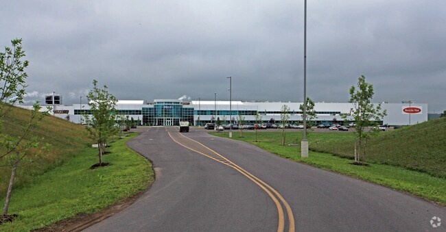
Property Record
1 Nutritious Pl, Amsterdam, NY 12010

NEARBY LISTINGS FOR SALE OR LEASE
Property Detail
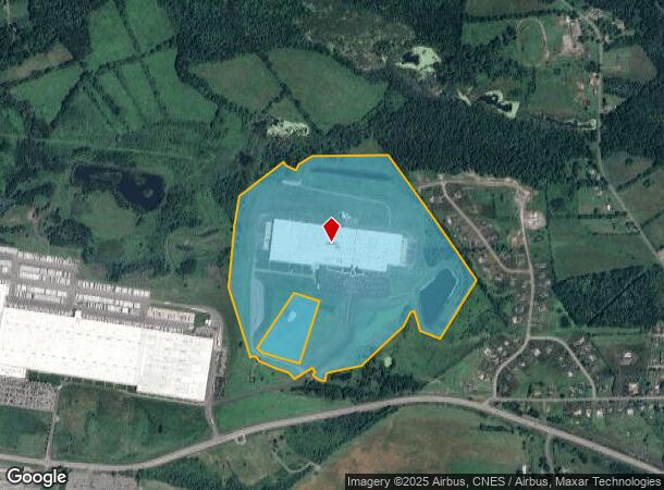
1 Nutritious Pl
272600-054-000-0001-034-011-0000
Montgomery
Commercialnec
New York
X
34.011
36057C0203E
95.30 AC
2025
Montgomery County
2024
Albany/Schenectady/Troy
072800
Amsterdam, NY
568,407 SF
DEMOGRAPHICS near 1 Nutritious Pl
1 Mile
3 Mile
5 Mile
2024 Total Population
533
19,036
26,738
2029 Population
527
18,997
26,676
Pop Growth 2024-2029
(1.13%)
(0.20%)
(0.23%)
Average Age
45
40
41
2024 Total Households
205
7,901
11,146
HH Growth 2024-2029
(0.98%)
(0.18%)
(0.22%)
Median Household Inc
$78,182
$45,548
$50,263
Avg Household Size
2.40
2.30
2.30
2024 Avg HH Vehicles
2.00
1.00
2.00
Median Home Value
$148,333
$112,411
$131,533
Median Year Built
1947
1947
1948
Nearby Places
Map Layers
Map Styles
 Street
 Aerial
- Restaurants
- Banks
- Shops
- Fitness
- Groceries
PUBLIC TRANSPORTATION
COMMUTER RAIL
Amsterdam (Toronto - New York - VIA Rail)
DRIVE
WALK
Distance
Amsterdam (Toronto - New York - VIA Rail)
12 min
5.1 mi
Amsterdam Amtrak Station (Empire Service - Amtrak, Maple Leaf - Amtrak)
DRIVE
WALK
Distance
Amsterdam Amtrak Station (Empire Service - Amtrak, Maple Leaf - Amtrak)
12 min
5.1 mi
AIRPORT
Albany International
DRIVE
WALK
Distance
Albany International
49 min
30.7 mi
Freight Ports
Albany, NY Port
DRIVE
WALK
Distance
Albany, NY Port
51 min
37.4 mi
Nearby Properties
Address
Land Use
TOTAL SIZE
Lot Size
Zoning
Address
Land Use
TOTAL SIZE
Lot Size
Zoning
8,924 SF
241.40 AC
Address
Land Use
TOTAL SIZE
Lot Size
Zoning
756,760 SF
102.40 AC
Address
Land Use
TOTAL SIZE
Lot Size
Zoning
226,614 SF
4.80 AC
05 - COMME
Address
Land Use
TOTAL SIZE
Lot Size
Zoning
197,790 SF
13.90 AC
07 - MIXED
Address
Land Use
TOTAL SIZE
Lot Size
Zoning
126,707 SF
39.10 AC
Address
Land Use
TOTAL SIZE
Lot Size
Zoning
6.90 AC
Address
Land Use
TOTAL SIZE
Lot Size
Zoning
27,576 SF
42.80 AC
07 - MIXED
Address
Land Use
TOTAL SIZE
Lot Size
Zoning
26.20 AC
Address
Land Use
TOTAL SIZE
Lot Size
Zoning
69,900 SF
24 AC
Address
Land Use
TOTAL SIZE
Lot Size
Zoning
66,137 SF
45.40 AC
05 - COMME
Address
Land Use
TOTAL SIZE
Lot Size
Zoning
97,304 SF
41.90 AC
Address
Land Use
TOTAL SIZE
Lot Size
Zoning
80,111 SF
4.50 AC
05 - COMME
Address
Land Use
TOTAL SIZE
Lot Size
Zoning
54,169 SF
35 AC
07 - MIXED
Address
Land Use
TOTAL SIZE
Lot Size
Zoning
69,166 SF
22.90 AC
05 - COMME
Address
Land Use
TOTAL SIZE
Lot Size
Zoning
Address
Land Use
TOTAL SIZE
Lot Size
Zoning
86,164 SF
1.20 AC
05 - COMME
Address
Land Use
TOTAL SIZE
Lot Size
Zoning
37,618 SF
1.20 AC
05 - COMME
Address
Land Use
TOTAL SIZE
Lot Size
Zoning
51,667 SF
82 AC
07 - MIXED
Address
Land Use
TOTAL SIZE
Lot Size
Zoning
226,614 SF
1 AC
07 - MIXED
Address
Land Use
TOTAL SIZE
Lot Size
Zoning
Address
Land Use
TOTAL SIZE
Lot Size
Zoning
38,350 SF
6.50 AC
06 - INDUS
Address
Land Use
TOTAL SIZE
Lot Size
Zoning
98,388 SF
11.10 AC
06 - INDUS
Address
Land Use
TOTAL SIZE
Lot Size
Zoning
29,588 SF
2.40 AC
07 - MIXED
Address
Land Use
TOTAL SIZE
Lot Size
Zoning
4,160 SF
1.80 AC
07 - MIXED
Address
Land Use
TOTAL SIZE
Lot Size
Zoning
Address
Land Use
TOTAL SIZE
Lot Size
Zoning
53,949 SF
13.10 AC
Address
Land Use
TOTAL SIZE
Lot Size
Zoning
59,556 SF
1 AC
07 - MIXED
Address
Land Use
TOTAL SIZE
Lot Size
Zoning
70 AC
02
Address
Land Use
TOTAL SIZE
Lot Size
Zoning
23,724 SF
6.80 AC
05 - COMME
The World's #1 Commercial Real Estate Marketplace
Connect with us
© 2026 CoStar Group
The information above has been obtained from sources believed reliable. While we do not doubt its accuracy we have not verified it and make no guarantee, warranty or representation about it. It is your responsibility to independently confirm its accuracy and completeness. Any projections, opinions, assumptions, or estimates used are for example only and do not represent the current or future performance of the property. The value of this transaction to you depends on tax and other factors which should be evaluated by your tax, financial, and legal advisors. You and your advisors should conduct a careful, independent investigation of the property to determine to your satisfaction the suitability of the property for your needs.