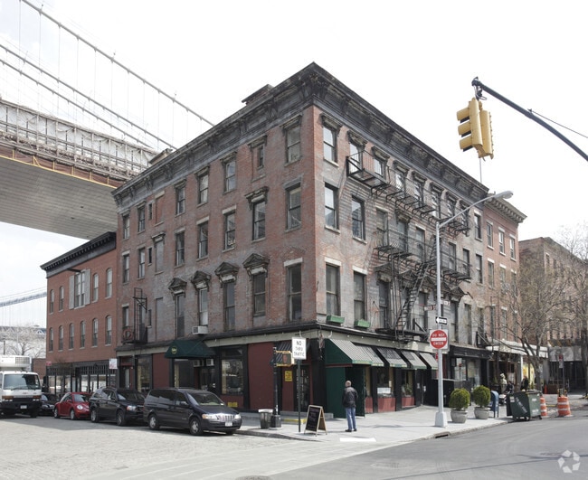
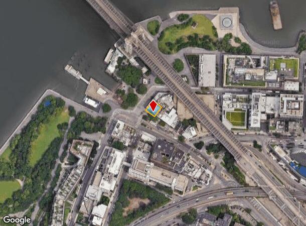
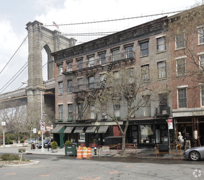
Property Record
1 Old Fulton St, Brooklyn, NY 11201
NEARBY LISTINGS FOR SALE OR LEASE
Property Detail
1 Old Fulton St
00035-0012
Kings
Transientlodging
New York
AE
12
3604970203F
0.09 AC
2024
Brooklyn Heights
2025
Long Island (New York)
002100
New York-Jersey City-White Plains, NY-NJ
13,689 SF
DEMOGRAPHICS near 1 Old Fulton St
1 Mile
3 Mile
5 Mile
2024 Total Population
142,125
1,116,079
2,696,940
2029 Population
134,694
1,058,838
2,546,815
Pop Growth 2024-2029
(5.23%)
(5.13%)
(5.57%)
Average Age
40
38
38
2024 Total Households
65,935
509,405
1,156,347
HH Growth 2024-2029
(5.46%)
(5.54%)
(5.87%)
Median Household Inc
$103,987
$107,304
$90,033
Avg Household Size
2.00
2.10
2.20
2024 Avg HH Vehicles
.00
.00
.00
Median Home Value
$943,102
$1,013,002
$915,809
Median Year Built
1956
1952
1951
Nearby Places
Map Layers
Map Styles
 Street
 Aerial
- Restaurants
- Banks
- Shops
- Fitness
- Groceries
PUBLIC TRANSPORTATION
TRANSIT/SUBWAY
High Street (A - New York MTA Subway (The Subway), C - New York MTA Subway (The Subway))
DRIVE
WALK
Distance
High Street (A - New York MTA Subway (The Subway), C - New York MTA Subway (The Subway))
1 min
7 min
0.4 mi
York Street (F - New York MTA Subway (The Subway))
DRIVE
WALK
Distance
York Street (F - New York MTA Subway (The Subway))
2 min
9 min
0.4 mi
Clark Street (2 - New York MTA Subway (The Subway), 3 - New York MTA Subway (The Subway))
DRIVE
WALK
Distance
Clark Street (2 - New York MTA Subway (The Subway), 3 - New York MTA Subway (The Subway))
2 min
9 min
0.5 mi
Borough Hall-Court Street (2 - New York MTA Subway (The Subway), 3 - New York MTA Subway (The Subway), 4 - New York MTA Subway (The Subway), 5 - New York MTA Subway (The Subway), M - New York MTA Subway (The Subway), N - New York MTA Subway (The Subway), R - New York MTA Subway (The Subway))
DRIVE
WALK
Distance
Borough Hall-Court Street (2 - New York MTA Subway (The Subway), 3 - New York MTA Subway (The Subway), 4 - New York MTA Subway (The Subway), 5 - New York MTA Subway (The Subway), M - New York MTA Subway (The Subway), N - New York MTA Subway (The Subway), R - New York MTA Subway (The Subway))
3 min
17 min
0.9 mi
Wall Street (2,3 Line) (2 - New York MTA Subway (The Subway), 3 - New York MTA Subway (The Subway))
DRIVE
WALK
Distance
Wall Street (2,3 Line) (2 - New York MTA Subway (The Subway), 3 - New York MTA Subway (The Subway))
8 min
14 min
1.0 mi
COMMUTER RAIL
DRIVE
WALK
Distance
7 min
2.2 mi
Christopher St (Hoboken-33rd Street - Port Authority Trans-Hudson (PATH), Journal Square-33rd Street - Port Authority Trans-Hudson (PATH))
DRIVE
WALK
Distance
Christopher St (Hoboken-33rd Street - Port Authority Trans-Hudson (PATH), Journal Square-33rd Street - Port Authority Trans-Hudson (PATH))
12 min
3.3 mi
AIRPORT
LaGuardia
DRIVE
WALK
Distance
LaGuardia
19 min
10.1 mi
Newark Liberty International
DRIVE
WALK
Distance
Newark Liberty International
25 min
14.4 mi
John F Kennedy International
DRIVE
WALK
Distance
John F Kennedy International
28 min
18.3 mi
Freight Ports
NY - Red Hook Container Terminal
DRIVE
WALK
Distance
NY - Red Hook Container Terminal
4 min
1.7 mi
Nearby Properties
Address
Land Use
TOTAL SIZE
Lot Size
Zoning
Address
Land Use
TOTAL SIZE
Lot Size
Zoning
8,462,176 SF
61.41 AC
R7-2
Address
Land Use
TOTAL SIZE
Lot Size
Zoning
2,161,994 SF
3.79 AC
M1-5
Address
Land Use
TOTAL SIZE
Lot Size
Zoning
2,354,289 SF
3.96 AC
C6-4
Address
Land Use
TOTAL SIZE
Lot Size
Zoning
2,812,739 SF
2.10 AC
C5-3
Address
Land Use
TOTAL SIZE
Lot Size
Zoning
2.38 AC
Address
Land Use
TOTAL SIZE
Lot Size
Zoning
1.75 AC
Address
Land Use
TOTAL SIZE
Lot Size
Zoning
2,157,862 SF
2.23 AC
BPC
Address
Land Use
TOTAL SIZE
Lot Size
Zoning
1,009,855 SF
4.90 AC
C6-3
Address
Land Use
TOTAL SIZE
Lot Size
Zoning
2,255,659 SF
4.58 AC
BPC
Address
Land Use
TOTAL SIZE
Lot Size
Zoning
2,124,441 SF
17.29 AC
R8
Address
Land Use
TOTAL SIZE
Lot Size
Zoning
Address
Land Use
TOTAL SIZE
Lot Size
Zoning
1,009,855 SF
3.25 AC
C6-3
Address
Land Use
TOTAL SIZE
Lot Size
Zoning
6.42 AC
Address
Land Use
TOTAL SIZE
Lot Size
Zoning
2,233,692 SF
1.90 AC
BPC
Address
Land Use
TOTAL SIZE
Lot Size
Zoning
1,233,394 SF
1.78 AC
C5-3
Address
Land Use
TOTAL SIZE
Lot Size
Zoning
2.21 AC
Address
Land Use
TOTAL SIZE
Lot Size
Zoning
1,104,505 SF
2.32 AC
C4-7
Address
Land Use
TOTAL SIZE
Lot Size
Zoning
1,560,607 SF
2.69 AC
C6-6
Address
Land Use
TOTAL SIZE
Lot Size
Zoning
1,636,000 SF
1.09 AC
C6-4
Address
Land Use
TOTAL SIZE
Lot Size
Zoning
1,909,502 SF
2.37 AC
BPC
Address
Land Use
TOTAL SIZE
Lot Size
Zoning
940,000 SF
1.44 AC
C6-2
Address
Land Use
TOTAL SIZE
Lot Size
Zoning
1,100,533 SF
3.79 AC
M1-5
Address
Land Use
TOTAL SIZE
Lot Size
Zoning
1,780,030 SF
5.07 AC
BPC
Address
Land Use
TOTAL SIZE
Lot Size
Zoning
7,058,736 SF
147.61 AC
M3-1
Address
Land Use
TOTAL SIZE
Lot Size
Zoning
869,038 SF
1.53 AC
M1-1
Address
Land Use
TOTAL SIZE
Lot Size
Zoning
1.04 AC
Address
Land Use
TOTAL SIZE
Lot Size
Zoning
1,260,362 SF
4.32 AC
C1-7
Address
Land Use
TOTAL SIZE
Lot Size
Zoning
1.87 AC
I-2
Address
Land Use
TOTAL SIZE
Lot Size
Zoning
1.84 AC
Address
Land Use
TOTAL SIZE
Lot Size
Zoning
512 SF
1.30 AC
R1
The World's #1 Commercial Real Estate Marketplace
Connect with us
© 2025 CoStar Group
The information above has been obtained from sources believed reliable. While we do not doubt its accuracy we have not verified it and make no guarantee, warranty or representation about it. It is your responsibility to independently confirm its accuracy and completeness. Any projections, opinions, assumptions, or estimates used are for example only and do not represent the current or future performance of the property. The value of this transaction to you depends on tax and other factors which should be evaluated by your tax, financial, and legal advisors. You and your advisors should conduct a careful, independent investigation of the property to determine to your satisfaction the suitability of the property for your needs.