Property Record
1 Plaza Pl, Bronx, NY 10465
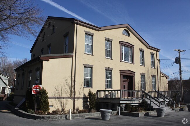

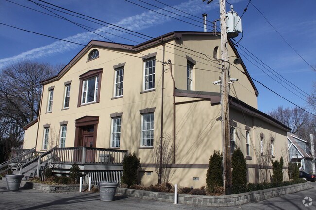

Property Detail
1 Plaza Pl
02583-0062
Bronx
Miscellaneous
New York
M3-1
62
VE and V1-30 Coastal areas with a 1% or greater chance of flooding and an additional hazard associated with storm waves. These areas have a 26% chance of flooding over the life of a 30-year mortgage.
9.47 AC
2025
Bronx
2026
Westchester/So Connecticut
011800
New York-Jersey City-White Plains, NY-NJ
15,000 SF
NEARBY LISTINGS FOR SALE OR LEASE
DEMOGRAPHICS near 1 Plaza Pl
1 mile
3 mile
5 mile
2025 Total Population
17,474
219,529
961,498
2030 Population
16,230
208,481
935,412
Pop Growth 2025-2030
(7.12%)
(5.03%)
(2.71%)
Average Age
41
42
41
2025 Total Households
5,999
78,481
336,804
HH Growth 2025-2030
(8.45%)
(5.44%)
(3.12%)
Median Household Inc
$80,473
$73,422
$60,666
Avg Household Size
2.60
2.70
2.70
2025 Avg HH Vehicles
1.00
1.00
1.00
Median Home Value
$600,913
$712,333
$695,971
Median Year Built
1958
1957
1957
Nearby Places
Map Layers
Map Styles
 Street
 Aerial
Layers
 Traffic
 Biking
Places
Listings with unknown addresses are not visible on the map
- Restaurants
- Banks
- Shops
- Fitness
- Groceries
PUBLIC TRANSPORTATION
COMMUTER RAIL
Murray Hill Station (Port Washington Branch - Long Island Rail Road)
Drive
Walk
Distance
Murray Hill Station (Port Washington Branch - Long Island Rail Road)
12 min
6.4 mi
Broadway Station (Port Washington Branch - Long Island Rail Road)
Drive
Walk
Distance
Broadway Station (Port Washington Branch - Long Island Rail Road)
11 min
6.7 mi
AIRPORT
LaGuardia
Drive
Walk
Distance
LaGuardia
21 min
9.7 mi
John F Kennedy International
Drive
Walk
Distance
John F Kennedy International
25 min
16.6 mi
Westchester County
Drive
Walk
Distance
Westchester County
37 min
23.7 mi
Freight Ports
NY - Red Hook Container Terminal
Drive
Walk
Distance
NY - Red Hook Container Terminal
33 min
21.4 mi
Nearby Properties
Address
Land Use
TOTAL SIZE
Lot Size
Zoning
Address
Land Use
TOTAL SIZE
Lot Size
Zoning
5,000 SF
363.58 AC
PARK
Address
Land Use
TOTAL SIZE
Lot Size
Zoning
1,012,000 SF
7.79 AC
R6
Address
Land Use
TOTAL SIZE
Lot Size
Zoning
703,265 SF
83.45 AC
R4
Address
Land Use
TOTAL SIZE
Lot Size
Zoning
421,996 SF
136.05 AC
R3-1
Address
Land Use
TOTAL SIZE
Lot Size
Zoning
4,050 SF
113.40 AC
PARK
Address
Land Use
TOTAL SIZE
Lot Size
Zoning
489,326 SF
19.18 AC
C8-1
Address
Land Use
TOTAL SIZE
Lot Size
Zoning
14,681 SF
97 AC
PARK
Address
Land Use
TOTAL SIZE
Lot Size
Zoning
510 SF
68.73 AC
PARK
Address
Land Use
TOTAL SIZE
Lot Size
Zoning
198,298 SF
13.93 AC
C4-1
Address
Land Use
TOTAL SIZE
Lot Size
Zoning
450,000 SF
5.59 AC
R6
Address
Land Use
TOTAL SIZE
Lot Size
Zoning
726,051 SF
33.66 AC
R5
Address
Land Use
TOTAL SIZE
Lot Size
Zoning
1,172,800 SF
19.66 AC
R4
Address
Land Use
TOTAL SIZE
Lot Size
Zoning
454,631 SF
24.61 AC
M1-1
Address
Land Use
TOTAL SIZE
Lot Size
Zoning
443,492 SF
27.75 AC
M1-1
Address
Land Use
TOTAL SIZE
Lot Size
Zoning
15.83 AC
M2-1
Address
Land Use
TOTAL SIZE
Lot Size
Zoning
164,110 SF
8.07 AC
M1-2
Address
Land Use
TOTAL SIZE
Lot Size
Zoning
239,223 SF
2.66 AC
R4
Address
Land Use
TOTAL SIZE
Lot Size
Zoning
330,240 SF
13.62 AC
C4-1
Address
Land Use
TOTAL SIZE
Lot Size
Zoning
105,000 SF
0.85 AC
R5
Address
Land Use
TOTAL SIZE
Lot Size
Zoning
1,021,752 SF
6.93 AC
R6
Address
Land Use
TOTAL SIZE
Lot Size
Zoning
163,200 SF
3.33 AC
R5
Address
Land Use
TOTAL SIZE
Lot Size
Zoning
127,291 SF
8.07 AC
M1-2
Address
Land Use
TOTAL SIZE
Lot Size
Zoning
638,539 SF
10.96 AC
R5
Address
Land Use
TOTAL SIZE
Lot Size
Zoning
158,282 SF
2.38 AC
R4A
Address
Land Use
TOTAL SIZE
Lot Size
Zoning
576,012 SF
12.02 AC
R5
Address
Land Use
TOTAL SIZE
Lot Size
Zoning
162,416 SF
3.25 AC
R6
Address
Land Use
TOTAL SIZE
Lot Size
Zoning
540 SF
64.97 AC
PARK
Address
Land Use
TOTAL SIZE
Lot Size
Zoning
576,011 SF
12.02 AC
R5
Address
Land Use
TOTAL SIZE
Lot Size
Zoning
137,699 SF
8.95 AC
M1-1
Address
Land Use
TOTAL SIZE
Lot Size
Zoning
107,290 SF
8.66 AC
C4-1
The World's #1 Commercial Real Estate Marketplace
Connect with us
© 2026 CoStar Group
The information above has been obtained from sources believed reliable. While we do not doubt its accuracy we have not verified it and make no guarantee, warranty or representation about it. It is your responsibility to independently confirm its accuracy and completeness. Any projections, opinions, assumptions, or estimates used are for example only and do not represent the current or future performance of the property. The value of this transaction to you depends on tax and other factors which should be evaluated by your tax, financial, and legal advisors. You and your advisors should conduct a careful, independent investigation of the property to determine to your satisfaction the suitability of the property for your needs.