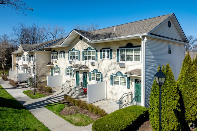
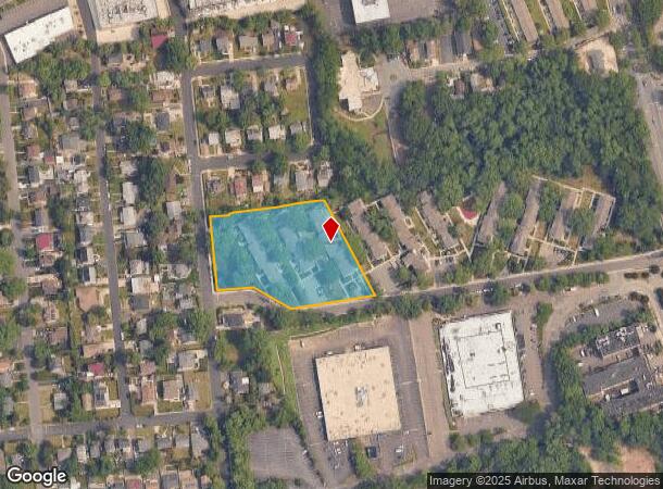
Property Record
1 Pond Hill Rd, Great Neck, NY 11020
NEARBY LISTINGS FOR SALE OR LEASE
Property Detail
1 Pond Hill Rd
2289-02-347-00-0049-0
TOWN #2 SCH DIST 006
Apartment
Nassau
X
New York
36059C0112G
49
2025
2.16 AC
2025
Manhasset
301800
Long Island (New York)
50,199 SF
Nassau County-Suffolk County, NY
DEMOGRAPHICS near 1 Pond Hill Rd
1 Mile
3 Mile
5 Mile
2024 Total Population
13,320
140,335
467,166
2029 Population
13,201
136,799
448,732
Pop Growth 2024-2029
(0.89%)
(2.52%)
(3.95%)
Average Age
44
45
44
2024 Total Households
5,102
49,941
164,857
HH Growth 2024-2029
(0.88%)
(2.85%)
(4.25%)
Median Household Inc
$120,463
$127,541
$112,879
Avg Household Size
2.50
2.70
2.70
2024 Avg HH Vehicles
2.00
2.00
2.00
Median Home Value
$910,480
$878,856
$782,589
Median Year Built
1953
1955
1954
Nearby Places
- Restaurants
- Banks
- Shops
- Fitness
- Groceries
PUBLIC TRANSPORTATION
COMMUTER RAIL
Great Neck Station (Port Washington Branch - Long Island Rail Road)
DRIVE
WALK
Distance
Great Neck Station (Port Washington Branch - Long Island Rail Road)
3 min
1.4 mi
Manhasset Station (Port Washington Branch - Long Island Rail Road)
DRIVE
WALK
Distance
Manhasset Station (Port Washington Branch - Long Island Rail Road)
3 min
1.5 mi
AIRPORT
LaGuardia
DRIVE
WALK
Distance
LaGuardia
21 min
12.4 mi
John F Kennedy International
DRIVE
WALK
Distance
John F Kennedy International
25 min
15.7 mi
Westchester County
DRIVE
WALK
Distance
Westchester County
50 min
31.7 mi
Freight Ports
NY - Red Hook Container Terminal
DRIVE
WALK
Distance
NY - Red Hook Container Terminal
32 min
20.5 mi
Nearby Properties
Address
Land Use
TOTAL SIZE
Lot Size
Zoning
Address
Land Use
TOTAL SIZE
Lot Size
Zoning
2,697,663 SF
3.46 AC
C5-3
Address
Land Use
TOTAL SIZE
Lot Size
Zoning
1,666,696 SF
1.87 AC
C52.5
Address
Land Use
TOTAL SIZE
Lot Size
Zoning
7,975 SF
133 AC
PARK
Address
Land Use
TOTAL SIZE
Lot Size
Zoning
1,667,567 SF
30 AC
R3-2
Address
Land Use
TOTAL SIZE
Lot Size
Zoning
202,459 SF
82.16 AC
R3-2
Address
Land Use
TOTAL SIZE
Lot Size
Zoning
1,800 SF
54.60 AC
PARK
Address
Land Use
TOTAL SIZE
Lot Size
Zoning
201,770 SF
7.09 AC
R3-2
Address
Land Use
TOTAL SIZE
Lot Size
Zoning
268,500 SF
27.50 AC
R4
Address
Land Use
TOTAL SIZE
Lot Size
Zoning
32,000 SF
50 AC
PARK
Address
Land Use
TOTAL SIZE
Lot Size
Zoning
344,292 SF
12.56 AC
R4
Address
Land Use
TOTAL SIZE
Lot Size
Zoning
95.36 AC
PARK
Address
Land Use
TOTAL SIZE
Lot Size
Zoning
111,122 SF
8.94 AC
R3-2
Address
Land Use
TOTAL SIZE
Lot Size
Zoning
123,832 SF
5.29 AC
R3-2
Address
Land Use
TOTAL SIZE
Lot Size
Zoning
231,865 SF
9.99 AC
C4-1
Address
Land Use
TOTAL SIZE
Lot Size
Zoning
356,093 SF
3 AC
R3-2
Address
Land Use
TOTAL SIZE
Lot Size
Zoning
171,000 SF
2.76 AC
R2A
Address
Land Use
TOTAL SIZE
Lot Size
Zoning
11.30 AC
PARK
Address
Land Use
TOTAL SIZE
Lot Size
Zoning
161,500 SF
3.44 AC
R3-2
Address
Land Use
TOTAL SIZE
Lot Size
Zoning
400 SF
25.80 AC
PARK
Address
Land Use
TOTAL SIZE
Lot Size
Zoning
224,106 SF
6.72 AC
M1-1
Address
Land Use
TOTAL SIZE
Lot Size
Zoning
43,190 SF
6.64 AC
R3-2
Address
Land Use
TOTAL SIZE
Lot Size
Zoning
114,000 SF
4.36 AC
R3-2
Address
Land Use
TOTAL SIZE
Lot Size
Zoning
243,883 SF
3.51 AC
R6A
Address
Land Use
TOTAL SIZE
Lot Size
Zoning
7.82 AC
PARK
Address
Land Use
TOTAL SIZE
Lot Size
Zoning
38,014 SF
1.29 AC
M1-1
Address
Land Use
TOTAL SIZE
Lot Size
Zoning
97,081 SF
2.08 AC
R4
Address
Land Use
TOTAL SIZE
Lot Size
Zoning
441,908 SF
13.41 AC
R3-2
Address
Land Use
TOTAL SIZE
Lot Size
Zoning
75,600 SF
2.35 AC
R3-2
Address
Land Use
TOTAL SIZE
Lot Size
Zoning
45,440 SF
3.15 AC
R3-2
Address
Land Use
TOTAL SIZE
Lot Size
Zoning
70,734 SF
2.94 AC
R2A
The World's #1 Commercial Real Estate Marketplace
Connect with us
© 2025 CoStar Group
The information above has been obtained from sources believed reliable. While we do not doubt its accuracy we have not verified it and make no guarantee, warranty or representation about it. It is your responsibility to independently confirm its accuracy and completeness. Any projections, opinions, assumptions, or estimates used are for example only and do not represent the current or future performance of the property. The value of this transaction to you depends on tax and other factors which should be evaluated by your tax, financial, and legal advisors. You and your advisors should conduct a careful, independent investigation of the property to determine to your satisfaction the suitability of the property for your needs.