Property Record
1 Ponto Rd, Carlsbad, CA 92011

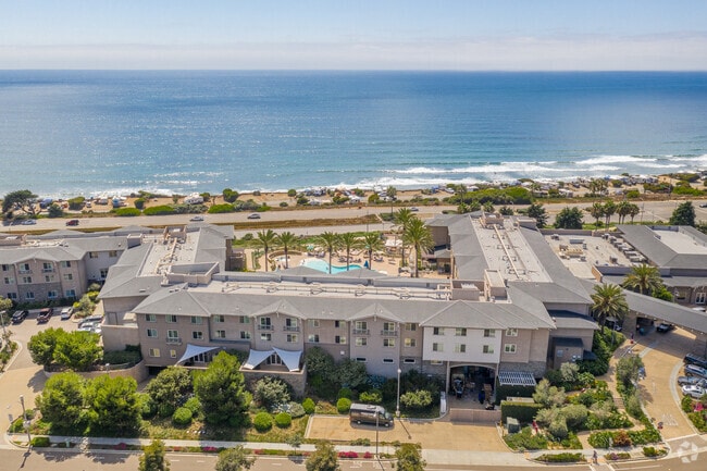
Property Detail
1 Ponto Rd
San Diego-Chula Vista-Carlsbad, CA
PAR 2 PAR 1 OF PM20900 IN TR PM18332
214-160-37
SAN DIEGO
Hotel
California
C-T
4
B and X Area of moderate flood hazard, usually the area between the limits of the 100-year and 500-year floods.
5.45 AC
2024
Carlsbad/Oceanside
2025
San Diego
017811
NEARBY LISTINGS FOR SALE OR LEASE
-
-
View all Carlsbad listings for sale on LoopNet.com
DEMOGRAPHICS near 1 Ponto Rd
1 mile
3 mile
5 mile
2025 Total Population
8,147
39,724
134,057
2030 Population
8,201
40,125
135,170
Pop Growth 2025-2030
+ 0.66%
+ 1.01%
+ 0.83%
Average Age
45
44
43
2025 Total Households
3,370
15,982
52,968
HH Growth 2025-2030
+ 0.50%
+ 0.94%
+ 0.82%
Median Household Inc
$156,340
$163,210
$150,287
Avg Household Size
2.40
2.40
2.50
2025 Avg HH Vehicles
2.00
2.00
2.00
Median Home Value
$1,079,647
$1,106,028
$1,098,110
Median Year Built
1991
1990
1986
Nearby Places
Map Layers
Map Styles
 Street
 Aerial
Layers
 Traffic
 Biking
Places
Listings with unknown addresses are not visible on the map
- Restaurants
- Banks
- Shops
- Fitness
- Groceries
PUBLIC TRANSPORTATION
COMMUTER RAIL
Carlsbad Poinsettia (Coaster - San Diego North County Transit District (Coaster/Sprinter/Breeze))
Drive
Walk
Distance
Carlsbad Poinsettia (Coaster - San Diego North County Transit District (Coaster/Sprinter/Breeze))
3 min
17 min
0.9 mi
Encinitas (Coaster - San Diego North County Transit District (Coaster/Sprinter/Breeze))
Drive
Walk
Distance
Encinitas (Coaster - San Diego North County Transit District (Coaster/Sprinter/Breeze))
7 min
4.1 mi
AIRPORT
San Diego International
Drive
Walk
Distance
San Diego International
36 min
28.4 mi
Freight Ports
Port of San Diego
Drive
Walk
Distance
Port of San Diego
41 min
32.7 mi
Nearby Properties
Address
Land Use
TOTAL SIZE
Lot Size
Zoning
Address
Land Use
TOTAL SIZE
Lot Size
Zoning
132.11 AC
C-T-Q
Address
Land Use
TOTAL SIZE
Lot Size
Zoning
26.65 AC
C-2-Q
Address
Land Use
TOTAL SIZE
Lot Size
Zoning
12.62 AC
P-C
Address
Land Use
TOTAL SIZE
Lot Size
Zoning
4.32 AC
N-LVSC
Address
Land Use
TOTAL SIZE
Lot Size
Zoning
12.71 AC
P-M
Address
Land Use
TOTAL SIZE
Lot Size
Zoning
16.79 AC
R-3-Q
Address
Land Use
TOTAL SIZE
Lot Size
Zoning
13.07 AC
P-M
Address
Land Use
TOTAL SIZE
Lot Size
Zoning
18.34 AC
P-C
Address
Land Use
TOTAL SIZE
Lot Size
Zoning
9.69 AC
C-T-Q
Address
Land Use
TOTAL SIZE
Lot Size
Zoning
20.86 AC
P-M-Q
Address
Land Use
TOTAL SIZE
Lot Size
Zoning
14.73 AC
C-L
Address
Land Use
TOTAL SIZE
Lot Size
Zoning
60.48 AC
OS
Address
Land Use
TOTAL SIZE
Lot Size
Zoning
11.10 AC
RD-M-Q
Address
Land Use
TOTAL SIZE
Lot Size
Zoning
3.17 AC
C-T
Address
Land Use
TOTAL SIZE
Lot Size
Zoning
7.42 AC
P-M
Address
Land Use
TOTAL SIZE
Lot Size
Zoning
7.38 AC
P-M-Q
Address
Land Use
TOTAL SIZE
Lot Size
Zoning
8.64 AC
R-3-Q
Address
Land Use
TOTAL SIZE
Lot Size
Zoning
55,656 SF
13.04 AC
R-1-Q
Address
Land Use
TOTAL SIZE
Lot Size
Zoning
9.76 AC
M
Address
Land Use
TOTAL SIZE
Lot Size
Zoning
88,188 SF
1.95 AC
N-R3
Address
Land Use
TOTAL SIZE
Lot Size
Zoning
65,359 SF
3.71 AC
C-2-Q
Address
Land Use
TOTAL SIZE
Lot Size
Zoning
9.15 AC
RD-M-Q
Address
Land Use
TOTAL SIZE
Lot Size
Zoning
89,000 SF
8.61 AC
O
Address
Land Use
TOTAL SIZE
Lot Size
Zoning
81,712 SF
4.70 AC
P-M-Q
Address
Land Use
TOTAL SIZE
Lot Size
Zoning
50,039 SF
0.75 AC
O
Address
Land Use
TOTAL SIZE
Lot Size
Zoning
91,887 SF
1.54 AC
C
Address
Land Use
TOTAL SIZE
Lot Size
Zoning
76,444 SF
4.59 AC
P-C
Address
Land Use
TOTAL SIZE
Lot Size
Zoning
84,496 SF
5.09 AC
P-M-Q
Address
Land Use
TOTAL SIZE
Lot Size
Zoning
75,000 SF
3.79 AC
P-M-Q
The World's #1 Commercial Real Estate Marketplace
Connect with us
© 2026 CoStar Group
The information above has been obtained from sources believed reliable. While we do not doubt its accuracy we have not verified it and make no guarantee, warranty or representation about it. It is your responsibility to independently confirm its accuracy and completeness. Any projections, opinions, assumptions, or estimates used are for example only and do not represent the current or future performance of the property. The value of this transaction to you depends on tax and other factors which should be evaluated by your tax, financial, and legal advisors. You and your advisors should conduct a careful, independent investigation of the property to determine to your satisfaction the suitability of the property for your needs.