Property Record
1 Post Rd, Brookfield, MA 01506
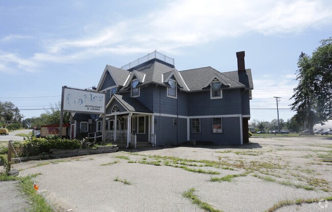

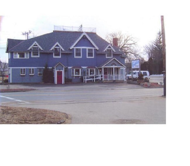
Property Detail
1 Post Rd
BROO-000006C-000001-000420
Worcester
Commercialofficeresidentialmixeduse
Massachusetts
BA
420
2025
0.80 AC
2025
Outlying Worcester
760100
Boston
4,872 SF
Worcester, MA
NEARBY LISTINGS FOR SALE OR LEASE
DEMOGRAPHICS near 1 Post Rd
1 mile
3 mile
5 mile
2024 Total Population
1,056
6,597
17,952
2029 Population
1,069
6,759
18,470
Pop Growth 2024-2029
+ 1.23%
+ 2.46%
+ 2.89%
Average Age
44
46
44
2024 Total Households
445
2,706
7,281
HH Growth 2024-2029
+ 1.35%
+ 2.62%
+ 2.98%
Median Household Inc
$65,300
$75,852
$83,012
Avg Household Size
2.40
2.40
2.40
2024 Avg HH Vehicles
2.00
2.00
2.00
Median Home Value
$343,023
$371,885
$385,894
Median Year Built
1947
1971
1971
Nearby Places
Map Layers
Map Styles
 Street
 Aerial
Transit
 Traffic
 Biking
Places
Listings with unknown addresses are not visible on the map
- Restaurants
- Banks
- Shops
- Fitness
- Groceries
PUBLIC TRANSPORTATION
AIRPORT
Worcester Regional
Drive
Walk
Distance
Worcester Regional
34 min
16.6 mi
Freight Ports
Port of Davisville, RI
Drive
Walk
Distance
Port of Davisville, RI
105 min
75.4 mi
Nearby Properties
Address
Land Use
TOTAL SIZE
Lot Size
Zoning
Address
Land Use
TOTAL SIZE
Lot Size
Zoning
76,000 SF
20.83 AC
RR
Address
Land Use
TOTAL SIZE
Lot Size
Zoning
104,040 SF
17.14 AC
V
Address
Land Use
TOTAL SIZE
Lot Size
Zoning
20,700 SF
1.37 AC
BA
Address
Land Use
TOTAL SIZE
Lot Size
Zoning
5,044 SF
15.93 AC
IN
Address
Land Use
TOTAL SIZE
Lot Size
Zoning
23,918 SF
4.97 AC
CD
Address
Land Use
TOTAL SIZE
Lot Size
Zoning
34,368 SF
12.50 AC
RR
Address
Land Use
TOTAL SIZE
Lot Size
Zoning
18,744 SF
5.80 AC
GD
Address
Land Use
TOTAL SIZE
Lot Size
Zoning
1,989 SF
4.06 AC
GD
Address
Land Use
TOTAL SIZE
Lot Size
Zoning
46,980 SF
15.07 AC
GD
Address
Land Use
TOTAL SIZE
Lot Size
Zoning
42,853 SF
0.64 AC
GD
Address
Land Use
TOTAL SIZE
Lot Size
Zoning
522.88 AC
66
Address
Land Use
TOTAL SIZE
Lot Size
Zoning
499 AC
RR
Address
Land Use
TOTAL SIZE
Lot Size
Zoning
700 SF
7 AC
CD
Address
Land Use
TOTAL SIZE
Lot Size
Zoning
64,568 SF
25.09 AC
IN
Address
Land Use
TOTAL SIZE
Lot Size
Zoning
17,378 SF
0.37 AC
GD
Address
Land Use
TOTAL SIZE
Lot Size
Zoning
2,340 SF
75.98 AC
RR
Address
Land Use
TOTAL SIZE
Lot Size
Zoning
10,986 SF
0.72 AC
V
Address
Land Use
TOTAL SIZE
Lot Size
Zoning
3,161 SF
1 AC
GD
Address
Land Use
TOTAL SIZE
Lot Size
Zoning
16,082 SF
4.20 AC
R
Address
Land Use
TOTAL SIZE
Lot Size
Zoning
57,094 SF
4.68 AC
GD
Address
Land Use
TOTAL SIZE
Lot Size
Zoning
9,836 SF
0.73 AC
GD
Address
Land Use
TOTAL SIZE
Lot Size
Zoning
353.60 AC
RR
Address
Land Use
TOTAL SIZE
Lot Size
Zoning
351.25 AC
RR
Address
Land Use
TOTAL SIZE
Lot Size
Zoning
11,727 SF
0.44 AC
V
Address
Land Use
TOTAL SIZE
Lot Size
Zoning
76.76 AC
C
Address
Land Use
TOTAL SIZE
Lot Size
Zoning
12,000 SF
13.23 AC
C
Address
Land Use
TOTAL SIZE
Lot Size
Zoning
0.21 AC
GD
Address
Land Use
TOTAL SIZE
Lot Size
Zoning
1,424 SF
4.38 AC
R
Address
Land Use
TOTAL SIZE
Lot Size
Zoning
4,196 SF
3.20 AC
RR
Address
Land Use
TOTAL SIZE
Lot Size
Zoning
276.77 AC
RR
The World's #1 Commercial Real Estate Marketplace
Connect with us
© 2026 CoStar Group
The information above has been obtained from sources believed reliable. While we do not doubt its accuracy we have not verified it and make no guarantee, warranty or representation about it. It is your responsibility to independently confirm its accuracy and completeness. Any projections, opinions, assumptions, or estimates used are for example only and do not represent the current or future performance of the property. The value of this transaction to you depends on tax and other factors which should be evaluated by your tax, financial, and legal advisors. You and your advisors should conduct a careful, independent investigation of the property to determine to your satisfaction the suitability of the property for your needs.