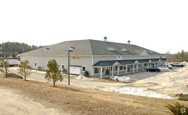
Property Record
1 Rebel Rd, Hudson, NH 03051
NEARBY LISTINGS FOR SALE OR LEASE
-
-
View all Hudson listings for sale on LoopNet.com
Property Detail
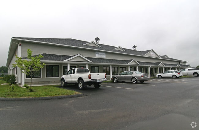
1 Rebel Rd
Industrialcondominium
Hillsborough
X
New Hampshire
33011C0508D
2
2024
Hillsborough
2024
Boston
012102
Manchester-Nashua, NH
4,181 SF
HDSO-000101-000030-000001
DEMOGRAPHICS near 1 Rebel Rd
1 Mile
3 Mile
5 Mile
2024 Total Population
1,615
19,547
71,230
2029 Population
1,668
20,185
73,343
Pop Growth 2024-2029
+ 3.28%
+ 3.26%
+ 2.97%
Average Age
42
42
42
2024 Total Households
575
7,062
27,154
HH Growth 2024-2029
+ 3.30%
+ 3.23%
+ 2.92%
Median Household Inc
$130,030
$131,563
$113,778
Avg Household Size
2.80
2.70
2.60
2024 Avg HH Vehicles
3.00
2.00
2.00
Median Home Value
$408,470
$407,990
$393,561
Median Year Built
1984
1983
1981
Nearby Places
Map Layers
Map Styles
 Street
 Aerial
- Restaurants
- Banks
- Shops
- Fitness
- Groceries
PUBLIC TRANSPORTATION
AIRPORT
Manchester Boston Regional
DRIVE
WALK
Distance
Manchester Boston Regional
24 min
9.7 mi
General Edward Lawrence Logan International
DRIVE
WALK
Distance
General Edward Lawrence Logan International
63 min
47.8 mi
Freight Ports
Port of Boston
DRIVE
WALK
Distance
Port of Boston
64 min
47.5 mi
Nearby Properties
Address
Land Use
TOTAL SIZE
Lot Size
Zoning
Address
Land Use
TOTAL SIZE
Lot Size
Zoning
188,520 SF
111.12 AC
GD
Address
Land Use
TOTAL SIZE
Lot Size
Zoning
80,863 SF
18 AC
R1
Address
Land Use
TOTAL SIZE
Lot Size
Zoning
38 AC
RES
Address
Land Use
TOTAL SIZE
Lot Size
Zoning
11.28 AC
C-I
Address
Land Use
TOTAL SIZE
Lot Size
Zoning
15,000 SF
C-III
Address
Land Use
TOTAL SIZE
Lot Size
Zoning
17.55 AC
RES
Address
Land Use
TOTAL SIZE
Lot Size
Zoning
45,330 SF
1 AC
R3
Address
Land Use
TOTAL SIZE
Lot Size
Zoning
69,900 SF
18.10 AC
BD
Address
Land Use
TOTAL SIZE
Lot Size
Zoning
44,280 SF
1 AC
R3
Address
Land Use
TOTAL SIZE
Lot Size
Zoning
2,400 SF
15.50 AC
G1
Address
Land Use
TOTAL SIZE
Lot Size
Zoning
31,091 SF
3.42 AC
BD
Address
Land Use
TOTAL SIZE
Lot Size
Zoning
684 SF
178.86 AC
G1
Address
Land Use
TOTAL SIZE
Lot Size
Zoning
8,596 SF
9.97 AC
GD
Address
Land Use
TOTAL SIZE
Lot Size
Zoning
13,560 SF
27.43 AC
R2
Address
Land Use
TOTAL SIZE
Lot Size
Zoning
11.94 AC
I1/2
Address
Land Use
TOTAL SIZE
Lot Size
Zoning
9,800 SF
10.09 AC
B
Address
Land Use
TOTAL SIZE
Lot Size
Zoning
256.45 AC
TRANSI
Address
Land Use
TOTAL SIZE
Lot Size
Zoning
12,300 SF
9.93 AC
AR-1/C
Address
Land Use
TOTAL SIZE
Lot Size
Zoning
67.75 AC
I1/2
Address
Land Use
TOTAL SIZE
Lot Size
Zoning
24,225 SF
7 AC
AR-I
Address
Land Use
TOTAL SIZE
Lot Size
Zoning
9,960 SF
3.11 AC
C-I
Address
Land Use
TOTAL SIZE
Lot Size
Zoning
600 SF
21.74 AC
ID
Address
Land Use
TOTAL SIZE
Lot Size
Zoning
9,600 SF
15.14 AC
C-II
Address
Land Use
TOTAL SIZE
Lot Size
Zoning
26.38 AC
TRANSI
Address
Land Use
TOTAL SIZE
Lot Size
Zoning
15,253 SF
5.09 AC
G1
Address
Land Use
TOTAL SIZE
Lot Size
Zoning
6.80 AC
H COMH
Address
Land Use
TOTAL SIZE
Lot Size
Zoning
80.37 AC
H COMH
Address
Land Use
TOTAL SIZE
Lot Size
Zoning
165.22 AC
G1
Address
Land Use
TOTAL SIZE
Lot Size
Zoning
38,230 SF
4.93 AC
G1
Address
Land Use
TOTAL SIZE
Lot Size
Zoning
31,620 SF
4.79 AC
H COMH
The World's #1 Commercial Real Estate Marketplace
Connect with us
© 2025 CoStar Group
The information above has been obtained from sources believed reliable. While we do not doubt its accuracy we have not verified it and make no guarantee, warranty or representation about it. It is your responsibility to independently confirm its accuracy and completeness. Any projections, opinions, assumptions, or estimates used are for example only and do not represent the current or future performance of the property. The value of this transaction to you depends on tax and other factors which should be evaluated by your tax, financial, and legal advisors. You and your advisors should conduct a careful, independent investigation of the property to determine to your satisfaction the suitability of the property for your needs.