Property Record
1 Reisner Way, Clinton, MA 01510


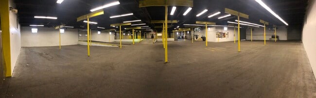
Current Lease Availabilities
Property Detail
1 Reisner Way
CLIN-000040-003525
WORCESTER
Industrialgeneral
Massachusetts
B and X Area of moderate flood hazard, usually the area between the limits of the 100-year and 500-year floods.
8.95 AC
2024
Outlying Worcester
2025
Boston
716300
Worcester, MA
NEARBY LISTINGS FOR SALE OR LEASE
DEMOGRAPHICS near 1 Reisner Way
1 mile
3 mile
5 mile
2025 Total Population
8,543
24,379
39,572
2030 Population
8,670
25,038
40,799
Pop Growth 2025-2030
+ 1.49%
+ 2.70%
+ 3.10%
Average Age
42
42
42
2025 Total Households
3,781
9,893
15,474
HH Growth 2025-2030
+ 1.59%
+ 2.73%
+ 3.15%
Median Household Inc
$91,005
$103,927
$111,150
Avg Household Size
2.20
2.40
2.50
2025 Avg HH Vehicles
2.00
2.00
2.00
Median Home Value
$392,294
$439,592
$494,122
Median Year Built
1949
1961
1969
Nearby Places
Map Layers
Map Styles
 Street
 Aerial
Layers
 Traffic
 Biking
Places
Listings with unknown addresses are not visible on the map
- Restaurants
- Banks
- Shops
- Fitness
- Groceries
PUBLIC TRANSPORTATION
AIRPORT
Worcester Regional
Drive
Walk
Distance
Worcester Regional
36 min
18.8 mi
Freight Ports
Port of Boston
Drive
Walk
Distance
Port of Boston
64 min
47.1 mi
Nearby Properties
Address
Land Use
TOTAL SIZE
Lot Size
Zoning
Address
Land Use
TOTAL SIZE
Lot Size
Zoning
26.80 AC
Address
Land Use
TOTAL SIZE
Lot Size
Zoning
344,000 SF
20.63 AC
Address
Land Use
TOTAL SIZE
Lot Size
Zoning
168,653 SF
6.50 AC
Address
Land Use
TOTAL SIZE
Lot Size
Zoning
455,636 SF
54.47 AC
Address
Land Use
TOTAL SIZE
Lot Size
Zoning
85,557 SF
9.27 AC
Address
Land Use
TOTAL SIZE
Lot Size
Zoning
64,497 SF
3.27 AC
Address
Land Use
TOTAL SIZE
Lot Size
Zoning
8.46 AC
Address
Land Use
TOTAL SIZE
Lot Size
Zoning
128,324 SF
1.03 AC
Address
Land Use
TOTAL SIZE
Lot Size
Zoning
174,412 SF
Address
Land Use
TOTAL SIZE
Lot Size
Zoning
12.69 AC
Address
Land Use
TOTAL SIZE
Lot Size
Zoning
2.37 AC
Address
Land Use
TOTAL SIZE
Lot Size
Zoning
147,092 SF
36.90 AC
Address
Land Use
TOTAL SIZE
Lot Size
Zoning
16,504 SF
0.45 AC
Address
Land Use
TOTAL SIZE
Lot Size
Zoning
5,050 SF
11.92 AC
Address
Land Use
TOTAL SIZE
Lot Size
Zoning
2.07 AC
Address
Land Use
TOTAL SIZE
Lot Size
Zoning
4,536 SF
48.38 AC
Address
Land Use
TOTAL SIZE
Lot Size
Zoning
158,900 SF
80 AC
Address
Land Use
TOTAL SIZE
Lot Size
Zoning
48,240 SF
0.59 AC
Address
Land Use
TOTAL SIZE
Lot Size
Zoning
116,116 SF
53.90 AC
Address
Land Use
TOTAL SIZE
Lot Size
Zoning
133,068 SF
9 AC
Address
Land Use
TOTAL SIZE
Lot Size
Zoning
1.61 AC
Address
Land Use
TOTAL SIZE
Lot Size
Zoning
884 SF
59.40 AC
R1
Address
Land Use
TOTAL SIZE
Lot Size
Zoning
33,050 SF
7.80 AC
Address
Land Use
TOTAL SIZE
Lot Size
Zoning
70,516 SF
23 AC
Address
Land Use
TOTAL SIZE
Lot Size
Zoning
12.66 AC
Address
Land Use
TOTAL SIZE
Lot Size
Zoning
201,446 SF
47.61 AC
R1
Address
Land Use
TOTAL SIZE
Lot Size
Zoning
0.01 AC
Address
Land Use
TOTAL SIZE
Lot Size
Zoning
7,344 SF
Address
Land Use
TOTAL SIZE
Lot Size
Zoning
26,939 SF
0.75 AC
Address
Land Use
TOTAL SIZE
Lot Size
Zoning
1.81 AC
The World's #1 Commercial Real Estate Marketplace
Connect with us
© 2026 CoStar Group
The information above has been obtained from sources believed reliable. While we do not doubt its accuracy we have not verified it and make no guarantee, warranty or representation about it. It is your responsibility to independently confirm its accuracy and completeness. Any projections, opinions, assumptions, or estimates used are for example only and do not represent the current or future performance of the property. The value of this transaction to you depends on tax and other factors which should be evaluated by your tax, financial, and legal advisors. You and your advisors should conduct a careful, independent investigation of the property to determine to your satisfaction the suitability of the property for your needs.