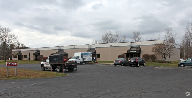
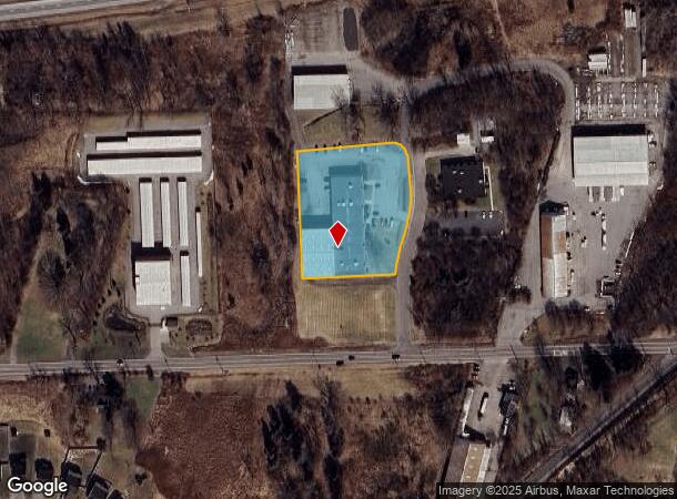
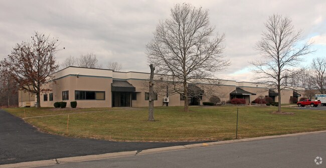
Property Record
1 Riverton Way, West Henrietta, NY 14586
NEARBY LISTINGS FOR SALE OR LEASE
Property Detail
1 Riverton Way
263200-188-020-0001-049-000
T LOT 24 6TH R 29600 1973 PREVIOUSLY:MARJAX
Officebuilding
Monroe
X
New York
36055C0337G
49.000
2025
2.12 AC
2024
South Central
013206
Rochester
29,600 SF
Rochester, NY
DEMOGRAPHICS near 1 Riverton Way
1 Mile
3 Mile
5 Mile
2024 Total Population
2,898
20,795
48,664
2029 Population
2,921
20,616
48,183
Pop Growth 2024-2029
+ 0.79%
(0.86%)
(0.99%)
Average Age
37
37
38
2024 Total Households
1,132
7,315
17,380
HH Growth 2024-2029
+ 0.88%
(0.92%)
(1.05%)
Median Household Inc
$71,138
$85,519
$74,636
Avg Household Size
2.50
2.60
2.40
2024 Avg HH Vehicles
2.00
2.00
2.00
Median Home Value
$202,667
$195,225
$178,907
Median Year Built
1996
1990
1978
Nearby Places
Map Layers
Map Styles
 Street
 Aerial
- Restaurants
- Banks
- Shops
- Fitness
- Groceries
PUBLIC TRANSPORTATION
AIRPORT
Frederick Douglass/Greater Rochester International
DRIVE
WALK
Distance
Frederick Douglass/Greater Rochester International
11 min
6.1 mi
Nearby Properties
Address
Land Use
TOTAL SIZE
Lot Size
Zoning
Address
Land Use
TOTAL SIZE
Lot Size
Zoning
2,440 SF
141.36 AC
06 - INDUS
Address
Land Use
TOTAL SIZE
Lot Size
Zoning
1,200 SF
34.17 AC
02 - SINGL
Address
Land Use
TOTAL SIZE
Lot Size
Zoning
1,772 SF
56.80 AC
02 - SINGL
Address
Land Use
TOTAL SIZE
Lot Size
Zoning
45,216 SF
12.42 AC
02 - SINGL
Address
Land Use
TOTAL SIZE
Lot Size
Zoning
364,000 SF
66.25 AC
06 - INDUS
Address
Land Use
TOTAL SIZE
Lot Size
Zoning
46,644 SF
26.60 AC
02 - SINGL
Address
Land Use
TOTAL SIZE
Lot Size
Zoning
11,108 SF
57.55 AC
06 - INDUS
Address
Land Use
TOTAL SIZE
Lot Size
Zoning
361,112 SF
54.84 AC
02 - SINGL
Address
Land Use
TOTAL SIZE
Lot Size
Zoning
156,248 SF
62.72 AC
06 - INDUS
Address
Land Use
TOTAL SIZE
Lot Size
Zoning
65.37 AC
02 - SINGL
Address
Land Use
TOTAL SIZE
Lot Size
Zoning
404,630 SF
21.44 AC
06 - INDUS
Address
Land Use
TOTAL SIZE
Lot Size
Zoning
160,692 SF
12.05 AC
06 - INDUS
Address
Land Use
TOTAL SIZE
Lot Size
Zoning
600 SF
446.14 AC
07 - MIXED
Address
Land Use
TOTAL SIZE
Lot Size
Zoning
138,633 SF
16.80 AC
05 - COMME
Address
Land Use
TOTAL SIZE
Lot Size
Zoning
181,876 SF
11.64 AC
07 - MIXED
Address
Land Use
TOTAL SIZE
Lot Size
Zoning
68,569 SF
42 AC
02 - SINGL
Address
Land Use
TOTAL SIZE
Lot Size
Zoning
187,805 SF
19.93 AC
03
Address
Land Use
TOTAL SIZE
Lot Size
Zoning
253,262 SF
20.48 AC
06 - INDUS
Address
Land Use
TOTAL SIZE
Lot Size
Zoning
10,884 SF
17.63 AC
03 - MULTI
Address
Land Use
TOTAL SIZE
Lot Size
Zoning
10,865 SF
10.48 AC
02 - SINGL
Address
Land Use
TOTAL SIZE
Lot Size
Zoning
86,225 SF
11.67 AC
06 - INDUS
Address
Land Use
TOTAL SIZE
Lot Size
Zoning
60,495 SF
12.12 AC
02 - SINGL
Address
Land Use
TOTAL SIZE
Lot Size
Zoning
111,762 SF
10.80 AC
06 - INDUS
Address
Land Use
TOTAL SIZE
Lot Size
Zoning
9,932 SF
9.91 AC
02 - SINGL
Address
Land Use
TOTAL SIZE
Lot Size
Zoning
350,300 SF
34.12 AC
07 - MIXED
Address
Land Use
TOTAL SIZE
Lot Size
Zoning
137,716 SF
13.23 AC
06 - INDUS
Address
Land Use
TOTAL SIZE
Lot Size
Zoning
52,019 SF
6.44 AC
06 - INDUS
Address
Land Use
TOTAL SIZE
Lot Size
Zoning
101,250 SF
13.57 AC
06 - INDUS
Address
Land Use
TOTAL SIZE
Lot Size
Zoning
100,000 SF
11.58 AC
07 - MIXED
Address
Land Use
TOTAL SIZE
Lot Size
Zoning
10,000 SF
81.90 AC
05 - COMME
The World's #1 Commercial Real Estate Marketplace
Connect with us
© 2026 CoStar Group
The information above has been obtained from sources believed reliable. While we do not doubt its accuracy we have not verified it and make no guarantee, warranty or representation about it. It is your responsibility to independently confirm its accuracy and completeness. Any projections, opinions, assumptions, or estimates used are for example only and do not represent the current or future performance of the property. The value of this transaction to you depends on tax and other factors which should be evaluated by your tax, financial, and legal advisors. You and your advisors should conduct a careful, independent investigation of the property to determine to your satisfaction the suitability of the property for your needs.