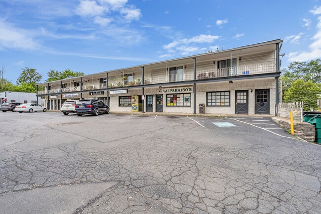
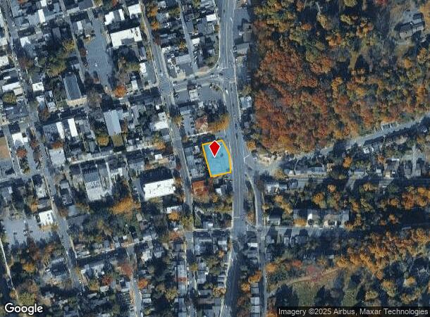
Property Record
1 Route 165, Lambertville, NJ 08530
NEARBY LISTINGS FOR SALE OR LEASE
-
-
View all Lambertville listings for sale on LoopNet.com
Property Detail
1 Route 165
17-01046-0000-00010
Hunterdon
Retailwithmorethanonenonretailuse
New Jersey
X
10
42017C0327J
0.30 AC
2024
Hunterdon County
2025
Northern New Jersey
011900
Newark, NJ-PA
11,316 SF
DEMOGRAPHICS near 1 Route 165
1 Mile
3 Mile
5 Mile
2024 Total Population
6,314
13,180
21,774
2029 Population
6,391
13,215
21,711
Pop Growth 2024-2029
+ 1.22%
+ 0.27%
(0.29%)
Average Age
48
48
47
2024 Total Households
3,165
6,000
9,285
HH Growth 2024-2029
+ 1.30%
+ 0.40%
(0.16%)
Median Household Inc
$103,842
$126,596
$139,545
Avg Household Size
2.00
2.20
2.30
2024 Avg HH Vehicles
2.00
2.00
2.00
Median Home Value
$491,614
$622,190
$670,207
Median Year Built
1959
1972
1973
Nearby Places
Map Layers
Map Styles
 Street
 Aerial
- Restaurants
- Banks
- Shops
- Fitness
- Groceries
PUBLIC TRANSPORTATION
AIRPORT
Trenton Mercer
DRIVE
WALK
Distance
Trenton Mercer
21 min
12.1 mi
Freight Ports
Port of Philadelphia
DRIVE
WALK
Distance
Port of Philadelphia
53 min
30.6 mi
SALE & LEASE HISTORY
LISTING DATE
SALE/LEASE

Oct 19, 2021
For Sale
Nearby Properties
Address
Land Use
TOTAL SIZE
Lot Size
Zoning
Address
Land Use
TOTAL SIZE
Lot Size
Zoning
11.51 AC
PRD
Address
Land Use
TOTAL SIZE
Lot Size
Zoning
4 AC
PRD
Address
Land Use
TOTAL SIZE
Lot Size
Zoning
Address
Land Use
TOTAL SIZE
Lot Size
Zoning
24,768 SF
1.47 AC
FP
Address
Land Use
TOTAL SIZE
Lot Size
Zoning
8,456 SF
2.36 AC
R-2
Address
Land Use
TOTAL SIZE
Lot Size
Zoning
7,765 SF
0.13 AC
CBD
Address
Land Use
TOTAL SIZE
Lot Size
Zoning
0.36 AC
CBD
Address
Land Use
TOTAL SIZE
Lot Size
Zoning
1,620 SF
0.23 AC
Address
Land Use
TOTAL SIZE
Lot Size
Zoning
4,924 SF
0.57 AC
CBD
Address
Land Use
TOTAL SIZE
Lot Size
Zoning
30,048 SF
22.12 AC
SRPD
Address
Land Use
TOTAL SIZE
Lot Size
Zoning
14,429 SF
2.20 AC
COM
Address
Land Use
TOTAL SIZE
Lot Size
Zoning
4,434 SF
1.47 AC
HC
Address
Land Use
TOTAL SIZE
Lot Size
Zoning
127.42 AC
MRC
Address
Land Use
TOTAL SIZE
Lot Size
Zoning
39,390 SF
1.80 AC
R-2
Address
Land Use
TOTAL SIZE
Lot Size
Zoning
540 SF
9.40 AC
LI
Address
Land Use
TOTAL SIZE
Lot Size
Zoning
100 AC
I-2
Address
Land Use
TOTAL SIZE
Lot Size
Zoning
4,200 SF
14.98 AC
HC
Address
Land Use
TOTAL SIZE
Lot Size
Zoning
4,423 SF
0.40 AC
R-2
Address
Land Use
TOTAL SIZE
Lot Size
Zoning
132.95 AC
MRC
Address
Land Use
TOTAL SIZE
Lot Size
Zoning
2,618 SF
83.19 AC
MRC
Address
Land Use
TOTAL SIZE
Lot Size
Zoning
105.42 AC
RR-5
Address
Land Use
TOTAL SIZE
Lot Size
Zoning
3,474 SF
4.09 AC
HC
Address
Land Use
TOTAL SIZE
Lot Size
Zoning
14,331 SF
3.88 AC
HC
Address
Land Use
TOTAL SIZE
Lot Size
Zoning
24,742 SF
0.11 AC
CBD
Address
Land Use
TOTAL SIZE
Lot Size
Zoning
5,600 SF
10.99 AC
HC
Address
Land Use
TOTAL SIZE
Lot Size
Zoning
9,100 SF
5.40 AC
HC
Address
Land Use
TOTAL SIZE
Lot Size
Zoning
11,452 SF
3.95 AC
PRD
Address
Land Use
TOTAL SIZE
Lot Size
Zoning
20,505 SF
0.14 AC
CBD
Address
Land Use
TOTAL SIZE
Lot Size
Zoning
8,396 SF
2 AC
RR-5
Address
Land Use
TOTAL SIZE
Lot Size
Zoning
0.42 AC
CBD
The World's #1 Commercial Real Estate Marketplace
Connect with us
© 2025 CoStar Group
The information above has been obtained from sources believed reliable. While we do not doubt its accuracy we have not verified it and make no guarantee, warranty or representation about it. It is your responsibility to independently confirm its accuracy and completeness. Any projections, opinions, assumptions, or estimates used are for example only and do not represent the current or future performance of the property. The value of this transaction to you depends on tax and other factors which should be evaluated by your tax, financial, and legal advisors. You and your advisors should conduct a careful, independent investigation of the property to determine to your satisfaction the suitability of the property for your needs.