Property Record
1 Row Montauk Hwy, East Moriches, NY 11940
NEARBY LISTINGS FOR SALE OR LEASE
-
-
View all East Moriches listings for sale on LoopNet.com
Property Detail
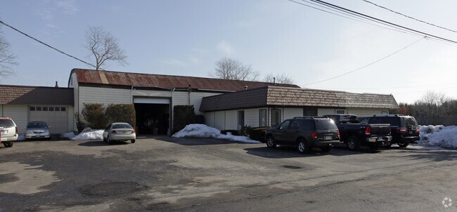
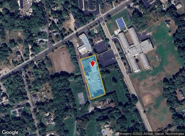
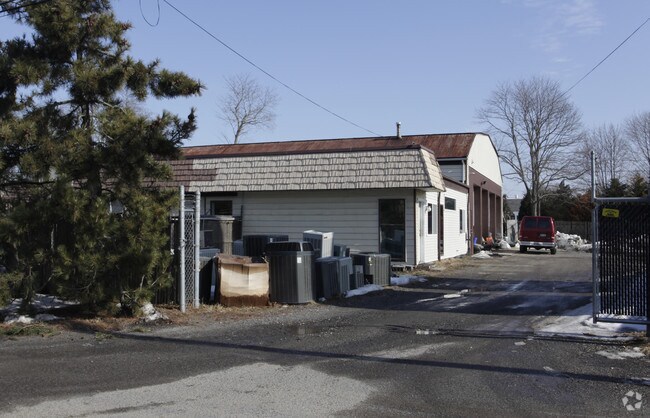
1 Row Montauk Hwy
Nassau County-Suffolk County, NY
East Moriches
0200-860-00-04-00-009-000
N TGW CORP E KANAS & ANO S BRANDT W
Commercialnec
Suffolk
X
New York
36103C0742H
9
2024
1.50 AC
2024
Eastern Suffolk
159406
Long Island (New York)
DEMOGRAPHICS near 1 Row Montauk Hwy
1 Mile
3 Mile
5 Mile
2024 Total Population
3,170
21,346
62,610
2029 Population
3,155
21,254
62,328
Pop Growth 2024-2029
(0.47%)
(0.43%)
(0.45%)
Average Age
44
43
41
2024 Total Households
1,135
7,555
21,488
HH Growth 2024-2029
(0.62%)
(0.60%)
(0.55%)
Median Household Inc
$120,048
$117,795
$106,366
Avg Household Size
2.60
2.70
2.80
2024 Avg HH Vehicles
2.00
2.00
2.00
Median Home Value
$671,428
$592,047
$457,394
Median Year Built
1975
1980
1980
Nearby Places
- Restaurants
- Banks
- Shops
- Fitness
- Groceries
PUBLIC TRANSPORTATION
COMMUTER RAIL
Speonk Station (Montauk Branch - Long Island Rail Road)
DRIVE
WALK
Distance
Speonk Station (Montauk Branch - Long Island Rail Road)
7 min
4.5 mi
Mastic-Shirley Station (Montauk Branch - Long Island Rail Road)
DRIVE
WALK
Distance
Mastic-Shirley Station (Montauk Branch - Long Island Rail Road)
12 min
6.0 mi
AIRPORT
Long Island MacArthur
DRIVE
WALK
Distance
Long Island MacArthur
33 min
19.6 mi
Freight Ports
Port of New Haven
DRIVE
WALK
Distance
Port of New Haven
148 min
60.2 mi
Nearby Properties
Address
Land Use
TOTAL SIZE
Lot Size
Zoning
Address
Land Use
TOTAL SIZE
Lot Size
Zoning
87,569 SF
19 AC
R120
Address
Land Use
TOTAL SIZE
Lot Size
Zoning
16.50 AC
VILLA
Address
Land Use
TOTAL SIZE
Lot Size
Zoning
8,636 SF
1.55 AC
R40
Address
Land Use
TOTAL SIZE
Lot Size
Zoning
9,069 SF
4.19 AC
R60
Address
Land Use
TOTAL SIZE
Lot Size
Zoning
5,122 SF
0.55 AC
VILLA
Address
Land Use
TOTAL SIZE
Lot Size
Zoning
8,098 SF
3 AC
R40
Address
Land Use
TOTAL SIZE
Lot Size
Zoning
6,975 SF
0.92 AC
R40
Address
Land Use
TOTAL SIZE
Lot Size
Zoning
1,984 SF
6.19 AC
R60
Address
Land Use
TOTAL SIZE
Lot Size
Zoning
5,897 SF
1.48 AC
R40
Address
Land Use
TOTAL SIZE
Lot Size
Zoning
16,654 SF
1.64 AC
R40
Address
Land Use
TOTAL SIZE
Lot Size
Zoning
8,282 SF
4.41 AC
R40
Address
Land Use
TOTAL SIZE
Lot Size
Zoning
150 SF
4.70 AC
RWB
Address
Land Use
TOTAL SIZE
Lot Size
Zoning
7,298 SF
1.40 AC
R80
Address
Land Use
TOTAL SIZE
Lot Size
Zoning
1.60 AC
R60
Address
Land Use
TOTAL SIZE
Lot Size
Zoning
9,256 SF
0.90 AC
R40
Address
Land Use
TOTAL SIZE
Lot Size
Zoning
1.30 AC
R60
Address
Land Use
TOTAL SIZE
Lot Size
Zoning
3,273 SF
1.10 AC
R20
Address
Land Use
TOTAL SIZE
Lot Size
Zoning
4,648 SF
0.92 AC
R40
Address
Land Use
TOTAL SIZE
Lot Size
Zoning
1 AC
VILLA
Address
Land Use
TOTAL SIZE
Lot Size
Zoning
1.20 AC
VILLA
Address
Land Use
TOTAL SIZE
Lot Size
Zoning
6,784 SF
0.78 AC
VILLA
Address
Land Use
TOTAL SIZE
Lot Size
Zoning
0.51 AC
VILLA
Address
Land Use
TOTAL SIZE
Lot Size
Zoning
2.53 AC
R60
Address
Land Use
TOTAL SIZE
Lot Size
Zoning
0.54 AC
VILLA
Address
Land Use
TOTAL SIZE
Lot Size
Zoning
0.76 AC
Address
Land Use
TOTAL SIZE
Lot Size
Zoning
8,656 SF
2.60 AC
R40
Address
Land Use
TOTAL SIZE
Lot Size
Zoning
9,312 SF
1.47 AC
R40
Address
Land Use
TOTAL SIZE
Lot Size
Zoning
7,753 SF
3.10 AC
R20
Address
Land Use
TOTAL SIZE
Lot Size
Zoning
3,779 SF
1.30 AC
R40
Address
Land Use
TOTAL SIZE
Lot Size
Zoning
6,234 SF
0.51 AC
R40
The World's #1 Commercial Real Estate Marketplace
Connect with us
© 2025 CoStar Group
The information above has been obtained from sources believed reliable. While we do not doubt its accuracy we have not verified it and make no guarantee, warranty or representation about it. It is your responsibility to independently confirm its accuracy and completeness. Any projections, opinions, assumptions, or estimates used are for example only and do not represent the current or future performance of the property. The value of this transaction to you depends on tax and other factors which should be evaluated by your tax, financial, and legal advisors. You and your advisors should conduct a careful, independent investigation of the property to determine to your satisfaction the suitability of the property for your needs.