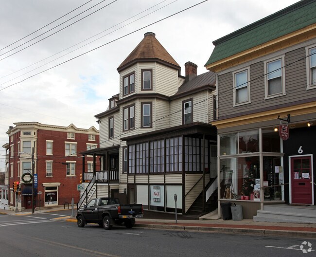
Property Record
1 S Maple Ave, Brunswick, MD 21716
Property Detail
1 S Maple Ave
25-478835
NEW PARCEL D 4,852 SQ FT BRUNSWICK
Commercialacreage
FREDERICK
B2 CB
Maryland
B and X Area of moderate flood hazard, usually the area between the limits of the 100-year and 500-year floods.
76
2024
0.11 AC
2025
Frederick
775400
Washington, DC
6,844 SF
Washington-Arlington-Alexandria, DC-VA-MD-WV
NEARBY LISTINGS FOR SALE OR LEASE
DEMOGRAPHICS near 1 S Maple Ave
1 mile
3 mile
5 mile
2025 Total Population
6,629
15,609
21,551
2030 Population
7,200
16,793
23,016
Pop Growth 2025-2030
+ 8.61%
+ 7.59%
+ 6.80%
Average Age
39
39
40
2025 Total Households
2,499
5,529
7,675
HH Growth 2025-2030
+ 8.68%
+ 7.74%
+ 6.92%
Median Household Inc
$97,573
$121,918
$123,378
Avg Household Size
2.60
2.80
2.80
2025 Avg HH Vehicles
2.00
2.00
2.00
Median Home Value
$325,266
$468,778
$492,850
Median Year Built
1975
1988
1986
Nearby Places
Map Layers
Map Styles
 Street
 Aerial
Layers
 Traffic
 Biking
Places
Listings with unknown addresses are not visible on the map
- Restaurants
- Banks
- Shops
- Fitness
- Groceries
PUBLIC TRANSPORTATION
TRANSIT/SUBWAY
Brunswick (Brunswick Line - Maryland Area Regional Commuter Trains (The MARC))
Drive
Walk
Distance
Brunswick (Brunswick Line - Maryland Area Regional Commuter Trains (The MARC))
1 min
1 min
0.1 mi
COMMUTER RAIL
Brunswick (Brunswick Line - Maryland Area Regional Commuter Trains (The MARC))
Drive
Walk
Distance
Brunswick (Brunswick Line - Maryland Area Regional Commuter Trains (The MARC))
1 min
1 min
0.1 mi
Harpers Ferry (Brunswick Line - Maryland Area Regional Commuter Trains (The MARC))
Drive
Walk
Distance
Harpers Ferry (Brunswick Line - Maryland Area Regional Commuter Trains (The MARC))
16 min
8.2 mi
AIRPORT
Hagerstown Regional/Richard A Henson Field
Drive
Walk
Distance
Hagerstown Regional/Richard A Henson Field
53 min
31.9 mi
Washington Dulles International
Drive
Walk
Distance
Washington Dulles International
56 min
35.1 mi
Nearby Properties
Address
Land Use
TOTAL SIZE
Lot Size
Zoning
Address
Land Use
TOTAL SIZE
Lot Size
Zoning
114,613 SF
24.63 AC
R1
Address
Land Use
TOTAL SIZE
Lot Size
Zoning
166,015 SF
18.41 AC
RS
Address
Land Use
TOTAL SIZE
Lot Size
Zoning
119,547 SF
50.30 AC
RS
Address
Land Use
TOTAL SIZE
Lot Size
Zoning
79,546 SF
10.86 AC
GC
Address
Land Use
TOTAL SIZE
Lot Size
Zoning
77,968 SF
8.11 AC
B2 CB
Address
Land Use
TOTAL SIZE
Lot Size
Zoning
18,531 SF
6.08 AC
LV:R1
Address
Land Use
TOTAL SIZE
Lot Size
Zoning
29,301 SF
5.87 AC
OR
Address
Land Use
TOTAL SIZE
Lot Size
Zoning
56,012 SF
2.43 AC
GC
Address
Land Use
TOTAL SIZE
Lot Size
Zoning
17,381 SF
1.60 AC
LV:TC
Address
Land Use
TOTAL SIZE
Lot Size
Zoning
23,582 SF
1.58 AC
B3
Address
Land Use
TOTAL SIZE
Lot Size
Zoning
40,000 SF
11.49 AC
I2
Address
Land Use
TOTAL SIZE
Lot Size
Zoning
13,840 SF
1.38 AC
LV:TC
Address
Land Use
TOTAL SIZE
Lot Size
Zoning
448 SF
4.27 AC
R1
Address
Land Use
TOTAL SIZE
Lot Size
Zoning
34,868 SF
2.23 AC
LV:C1
Address
Land Use
TOTAL SIZE
Lot Size
Zoning
15,376 SF
1.50 AC
R1
Address
Land Use
TOTAL SIZE
Lot Size
Zoning
34,387 SF
2.88 AC
I1
Address
Land Use
TOTAL SIZE
Lot Size
Zoning
33,501 SF
3.94 AC
R2
Address
Land Use
TOTAL SIZE
Lot Size
Zoning
23,038 SF
9 AC
OS
Address
Land Use
TOTAL SIZE
Lot Size
Zoning
6,942 SF
214.12 AC
A
Address
Land Use
TOTAL SIZE
Lot Size
Zoning
4,928 SF
2.05 AC
GC
Address
Land Use
TOTAL SIZE
Lot Size
Zoning
71,374 SF
0.58 AC
B2 CB
Address
Land Use
TOTAL SIZE
Lot Size
Zoning
23,994 SF
1.67 AC
R2
Address
Land Use
TOTAL SIZE
Lot Size
Zoning
6,000 SF
0.66 AC
LV:TC
Address
Land Use
TOTAL SIZE
Lot Size
Zoning
8,265 SF
1.16 AC
OR
Address
Land Use
TOTAL SIZE
Lot Size
Zoning
5,730 SF
1.25 AC
LV:C2
Address
Land Use
TOTAL SIZE
Lot Size
Zoning
4,502 SF
0.66 AC
LV:R3
Address
Land Use
TOTAL SIZE
Lot Size
Zoning
3,428 SF
8.02 AC
GC
Address
Land Use
TOTAL SIZE
Lot Size
Zoning
2,940 SF
0.90 AC
LV:C2
Address
Land Use
TOTAL SIZE
Lot Size
Zoning
11,980 SF
19.27 AC
OS
The World's #1 Commercial Real Estate Marketplace
Connect with us
© 2026 CoStar Group
The information above has been obtained from sources believed reliable. While we do not doubt its accuracy we have not verified it and make no guarantee, warranty or representation about it. It is your responsibility to independently confirm its accuracy and completeness. Any projections, opinions, assumptions, or estimates used are for example only and do not represent the current or future performance of the property. The value of this transaction to you depends on tax and other factors which should be evaluated by your tax, financial, and legal advisors. You and your advisors should conduct a careful, independent investigation of the property to determine to your satisfaction the suitability of the property for your needs.