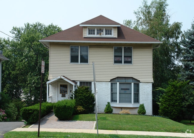
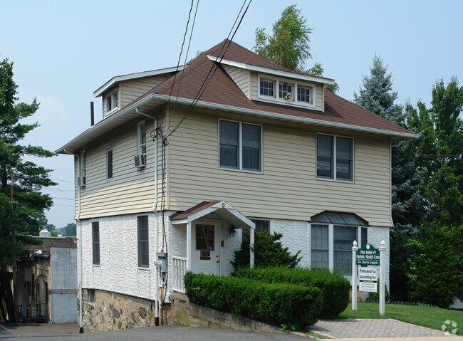
Property Record
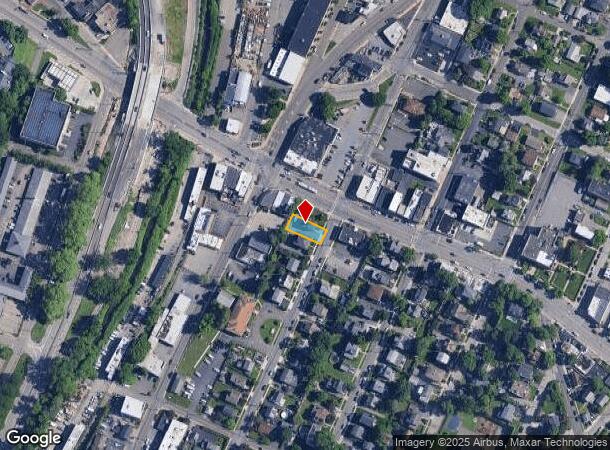
1 S Stone Ave, Elmsford, NY 10523

NEARBY LISTINGS FOR SALE OR LEASE
Property Detail
1 S Stone Ave
2605-005-040-00065-000-0009
Westchester
Commercialofficeresidentialmixeduse
New York
X
9.000
36119C0262F
0.12 AC
2025
West I-287 Corridor
2024
Westchester/So Connecticut
011200
New York-Jersey City-White Plains, NY-NJ
2,574 SF
DEMOGRAPHICS near 1 S Stone Ave
1 Mile
3 Mile
5 Mile
2024 Total Population
10,579
86,993
195,577
2029 Population
10,320
85,608
192,407
Pop Growth 2024-2029
(2.45%)
(1.59%)
(1.62%)
Average Age
41
42
42
2024 Total Households
3,648
33,223
73,831
HH Growth 2024-2029
(2.66%)
(1.64%)
(1.66%)
Median Household Inc
$127,252
$128,547
$132,163
Avg Household Size
2.80
2.50
2.50
2024 Avg HH Vehicles
2.00
2.00
2.00
Median Home Value
$599,833
$616,487
$682,355
Median Year Built
1966
1962
1959
Nearby Places
- Restaurants
- Banks
- Shops
- Fitness
- Groceries
PUBLIC TRANSPORTATION
COMMUTER RAIL
White Plains Station (Harlem Line - Metro-North Commuter Railroad Company (Metro-North))
DRIVE
WALK
Distance
White Plains Station (Harlem Line - Metro-North Commuter Railroad Company (Metro-North))
7 min
3.2 mi
North White Plains Station (Harlem Line - Metro-North Commuter Railroad Company (Metro-North))
DRIVE
WALK
Distance
North White Plains Station (Harlem Line - Metro-North Commuter Railroad Company (Metro-North))
6 min
3.8 mi
AIRPORT
Westchester County
DRIVE
WALK
Distance
Westchester County
17 min
11.4 mi
LaGuardia
DRIVE
WALK
Distance
LaGuardia
40 min
25.1 mi
John F Kennedy International
DRIVE
WALK
Distance
John F Kennedy International
52 min
34.4 mi
Freight Ports
NY - Red Hook Container Terminal
DRIVE
WALK
Distance
NY - Red Hook Container Terminal
53 min
33.3 mi
SALE & LEASE HISTORY
LISTING DATE
SALE/LEASE

Sep 24, 2016
For Sale
Nearby Properties
Address
Land Use
TOTAL SIZE
Lot Size
Zoning
Address
Land Use
TOTAL SIZE
Lot Size
Zoning
358.83 AC
Address
Land Use
TOTAL SIZE
Lot Size
Zoning
85.40 AC
Address
Land Use
TOTAL SIZE
Lot Size
Zoning
4.45 AC
B
Address
Land Use
TOTAL SIZE
Lot Size
Zoning
2,760 SF
60.76 AC
Address
Land Use
TOTAL SIZE
Lot Size
Zoning
63.40 AC
R-40
Address
Land Use
TOTAL SIZE
Lot Size
Zoning
63.48 AC
R-30
Address
Land Use
TOTAL SIZE
Lot Size
Zoning
22.92 AC
Address
Land Use
TOTAL SIZE
Lot Size
Zoning
75.87 AC
R-20
Address
Land Use
TOTAL SIZE
Lot Size
Zoning
Address
Land Use
TOTAL SIZE
Lot Size
Zoning
24.28 AC
Address
Land Use
TOTAL SIZE
Lot Size
Zoning
17.61 AC
Address
Land Use
TOTAL SIZE
Lot Size
Zoning
36.59 AC
Address
Land Use
TOTAL SIZE
Lot Size
Zoning
17.17 AC
Address
Land Use
TOTAL SIZE
Lot Size
Zoning
14.86 AC
OB
Address
Land Use
TOTAL SIZE
Lot Size
Zoning
24.66 AC
Address
Land Use
TOTAL SIZE
Lot Size
Zoning
16.22 AC
UR
Address
Land Use
TOTAL SIZE
Lot Size
Zoning
29.35 AC
Address
Land Use
TOTAL SIZE
Lot Size
Zoning
7.78 AC
Address
Land Use
TOTAL SIZE
Lot Size
Zoning
19.25 AC
Address
Land Use
TOTAL SIZE
Lot Size
Zoning
28.51 AC
Address
Land Use
TOTAL SIZE
Lot Size
Zoning
37.99 AC
Address
Land Use
TOTAL SIZE
Lot Size
Zoning
253,167 SF
9.11 AC
OB
Address
Land Use
TOTAL SIZE
Lot Size
Zoning
60.01 AC
Address
Land Use
TOTAL SIZE
Lot Size
Zoning
8.42 AC
Address
Land Use
TOTAL SIZE
Lot Size
Zoning
Address
Land Use
TOTAL SIZE
Lot Size
Zoning
22.44 AC
R-20
Address
Land Use
TOTAL SIZE
Lot Size
Zoning
26.50 AC
Address
Land Use
TOTAL SIZE
Lot Size
Zoning
205,000 SF
7.85 AC
Address
Land Use
TOTAL SIZE
Lot Size
Zoning
9.67 AC
Address
Land Use
TOTAL SIZE
Lot Size
Zoning
11.61 AC
The World's #1 Commercial Real Estate Marketplace
Connect with us
© 2025 CoStar Group
The information above has been obtained from sources believed reliable. While we do not doubt its accuracy we have not verified it and make no guarantee, warranty or representation about it. It is your responsibility to independently confirm its accuracy and completeness. Any projections, opinions, assumptions, or estimates used are for example only and do not represent the current or future performance of the property. The value of this transaction to you depends on tax and other factors which should be evaluated by your tax, financial, and legal advisors. You and your advisors should conduct a careful, independent investigation of the property to determine to your satisfaction the suitability of the property for your needs.