Property Record
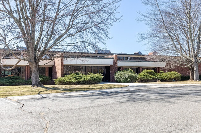
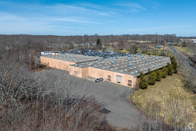
1 Seemar Rd, Watertown, CT 06795

Property Detail
1 Seemar Rd
WATE-000082-000089-000008A
Naugatuck Vly
Industrialgeneral
Connecticut
IR200
8a
2025
19 AC
2025
SE Litchfield County
360200
Hartford
125,770 SF
Torrington, CT
NEARBY LISTINGS FOR SALE OR LEASE
DEMOGRAPHICS near 1 Seemar Rd
1 mile
3 mile
5 mile
2025 Total Population
2,065
29,884
90,590
2030 Population
2,175
30,676
92,899
Pop Growth 2025-2030
+ 5.33%
+ 2.65%
+ 2.55%
Average Age
46
42
41
2025 Total Households
881
11,872
35,286
HH Growth 2025-2030
+ 5.22%
+ 2.64%
+ 2.62%
Median Household Inc
$85,360
$82,925
$69,617
Avg Household Size
2.30
2.40
2.50
2025 Avg HH Vehicles
2.00
2.00
2.00
Median Home Value
$402,941
$283,525
$277,762
Median Year Built
1980
1968
1962
Nearby Places
Map Layers
Map Styles
 Street
 Aerial
Transit
 Traffic
 Biking
Places
Listings with unknown addresses are not visible on the map
- Restaurants
- Banks
- Shops
- Fitness
- Groceries
PUBLIC TRANSPORTATION
COMMUTER RAIL
Waterbury Station (New Haven Line - Metro-North Commuter Railroad Company (Metro-North))
Drive
Walk
Distance
Waterbury Station (New Haven Line - Metro-North Commuter Railroad Company (Metro-North))
13 min
6.3 mi
AIRPORT
Tweed/New Haven
Drive
Walk
Distance
Tweed/New Haven
54 min
33.5 mi
Freight Ports
Port of New Haven
Drive
Walk
Distance
Port of New Haven
49 min
30.6 mi
SALE & LEASE HISTORY
LISTING DATE
SALE/LEASE

May 23, 2022
For Lease
Nearby Properties
Address
Land Use
TOTAL SIZE
Lot Size
Zoning
Address
Land Use
TOTAL SIZE
Lot Size
Zoning
276,286 SF
19.50 AC
IG80
Address
Land Use
TOTAL SIZE
Lot Size
Zoning
75 AC
R20
Address
Land Use
TOTAL SIZE
Lot Size
Zoning
155,861 SF
13.70 AC
R125
Address
Land Use
TOTAL SIZE
Lot Size
Zoning
201,817 SF
34.84 AC
R125
Address
Land Use
TOTAL SIZE
Lot Size
Zoning
140,700 SF
25.55 AC
R30
Address
Land Use
TOTAL SIZE
Lot Size
Zoning
65,974 SF
20.70 AC
RA15
Address
Land Use
TOTAL SIZE
Lot Size
Zoning
30.46 AC
RM
Address
Land Use
TOTAL SIZE
Lot Size
Zoning
72,336 SF
15.39 AC
R30
Address
Land Use
TOTAL SIZE
Lot Size
Zoning
24.60 AC
RM
Address
Land Use
TOTAL SIZE
Lot Size
Zoning
54,820 SF
1.03 AC
CA
Address
Land Use
TOTAL SIZE
Lot Size
Zoning
209.81 AC
R125
Address
Land Use
TOTAL SIZE
Lot Size
Zoning
326,357 SF
53.34 AC
IR200
Address
Land Use
TOTAL SIZE
Lot Size
Zoning
84,480 SF
11.06 AC
BSC
Address
Land Use
TOTAL SIZE
Lot Size
Zoning
15 AC
M1
Address
Land Use
TOTAL SIZE
Lot Size
Zoning
12.45 AC
RM
Address
Land Use
TOTAL SIZE
Lot Size
Zoning
60,703 SF
6.60 AC
R125
Address
Land Use
TOTAL SIZE
Lot Size
Zoning
47.80 AC
RS
Address
Land Use
TOTAL SIZE
Lot Size
Zoning
216,200 SF
12.43 AC
IG
Address
Land Use
TOTAL SIZE
Lot Size
Zoning
178,860 SF
52.98 AC
IR200
Address
Land Use
TOTAL SIZE
Lot Size
Zoning
1,154 SF
435 AC
R90
Address
Land Use
TOTAL SIZE
Lot Size
Zoning
14.98 AC
IR200
Address
Land Use
TOTAL SIZE
Lot Size
Zoning
3.86 AC
RM
Address
Land Use
TOTAL SIZE
Lot Size
Zoning
44,730 SF
4.25 AC
RM
Address
Land Use
TOTAL SIZE
Lot Size
Zoning
182,765 SF
9.08 AC
IG20F
Address
Land Use
TOTAL SIZE
Lot Size
Zoning
7.36 AC
RM
Address
Land Use
TOTAL SIZE
Lot Size
Zoning
128,480 SF
19.91 AC
IR200
Address
Land Use
TOTAL SIZE
Lot Size
Zoning
132,377 SF
11.91 AC
IG20
Address
Land Use
TOTAL SIZE
Lot Size
Zoning
19,508 SF
2.10 AC
BC
Address
Land Use
TOTAL SIZE
Lot Size
Zoning
96,721 SF
7.08 AC
IR200
The World's #1 Commercial Real Estate Marketplace
Connect with us
© 2026 CoStar Group
The information above has been obtained from sources believed reliable. While we do not doubt its accuracy we have not verified it and make no guarantee, warranty or representation about it. It is your responsibility to independently confirm its accuracy and completeness. Any projections, opinions, assumptions, or estimates used are for example only and do not represent the current or future performance of the property. The value of this transaction to you depends on tax and other factors which should be evaluated by your tax, financial, and legal advisors. You and your advisors should conduct a careful, independent investigation of the property to determine to your satisfaction the suitability of the property for your needs.